Donation drive starting early this year This January will mark ten full years where I began my forecasting pursuits. It has been an incredible journey that has taken me places and introduced me to people beyond any expectations. For many years I funded this on my own when I began Western Maine Weather. I wanted to use the same data sources that the TV and other professional meteorologists used. If I had a fighting chance to keep up with them, I had to have the same resources. After going through the School of Meteorological Hard Knocks and Busted Forecasts, I was able to learn a great deal. While I had some tutelage from TV folks, I learned hands on more than anything else. Pine Tree Weather began in 2016 as a blog on the Bangor Daily News, then moved to this website after the Great October Gale of 2017 and has been updated regularly ever since. In 2019 I made the first call for donations to pay my bills, and the support came quickly. In 2020, I asked for financial support again, and it took a bit longer to meet my goal. As a result, I am starting this process early this year, asking for your support now, ahead of the busy winter season that will be here soon enough.  Given the support of many of you in 2019, I took the initiative to apply to The Pennsylvania State University World Campus weather forecast certification program. This is how I spent my COVID isolation time, updating here and on Facebook while undergoing four straight rigorous semesters to learn more about the art of weather forecasting, which I completed formally in May. I have spent well over $20,000 out of my own pocket between weather data and education to get where I am today, and to deliver a product to you that is relatable and understandable beyond any weather app, a TV weather hit, or a weather story from a newspaper. It is a labor of love, but it comes at great cost in time and money. In the summer 2020, I began working with two students who needed to sharpen their forecast skills and build resume experience. The two from 2020 turned into six students for 2021. I have learned that I enjoy one-on-one teaching and sharing what I have learned with future meteorologists who will make much more money at this than I will … in a year. I will continue to do this ad free and without subscription so long as I have support from you to do so. I ask you one simple question, has Pine Tree Weather helped you along the way? If the answer is yes, then I ask for your financial support. Whether it is $5 or $500 in a lump sum through VENMO or a check or $5 a month on Patreon, it all adds up. For more information on donating, please check out the DONATE page, message me on Facebook or Twitter to ask questions if necessary. Thank you for those who have contributed in the past and continue to contribute. Without you, this entity would have gone away. I appreciate your trust, and your support. A look at the jet stream forecast through the week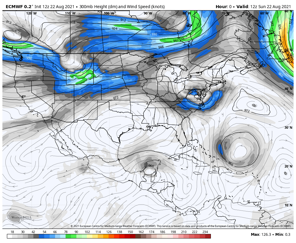 Early in the forecast one can see the upper-level wind from Henri spin itself out over New England. After that washes out, a strong ridge works into the region with warm temperatures and humidity into Thursday. At that point, and cold front knocks the ridge down over the region allowing cooler, drier air to funnel in, but there may be a smoky hue to the sky for the upcoming weekend as wildfires out west continue to burn. Another ridge appears to move into the region as we start the following week, with humidity levels on the increase once again. Henri spins itself out of gas through Tuesday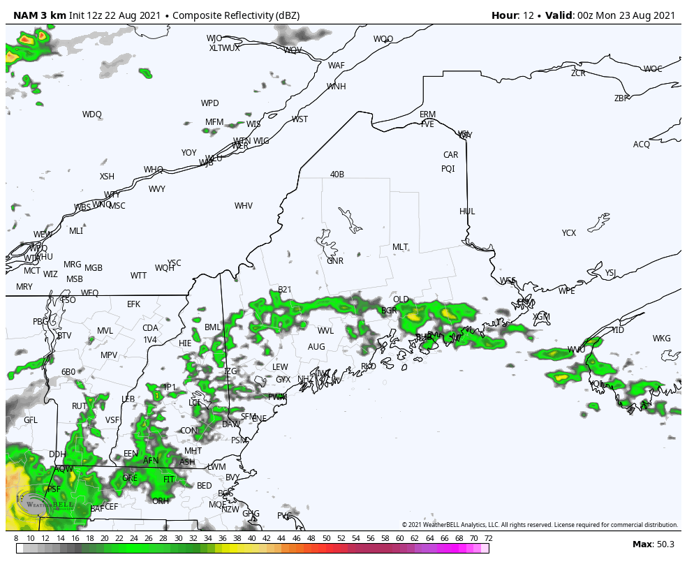 No real changes to the forecast mentioned here on Saturday. Scattered showers with a low chance for a thunderstorm is possible over the region through the day on Monday. 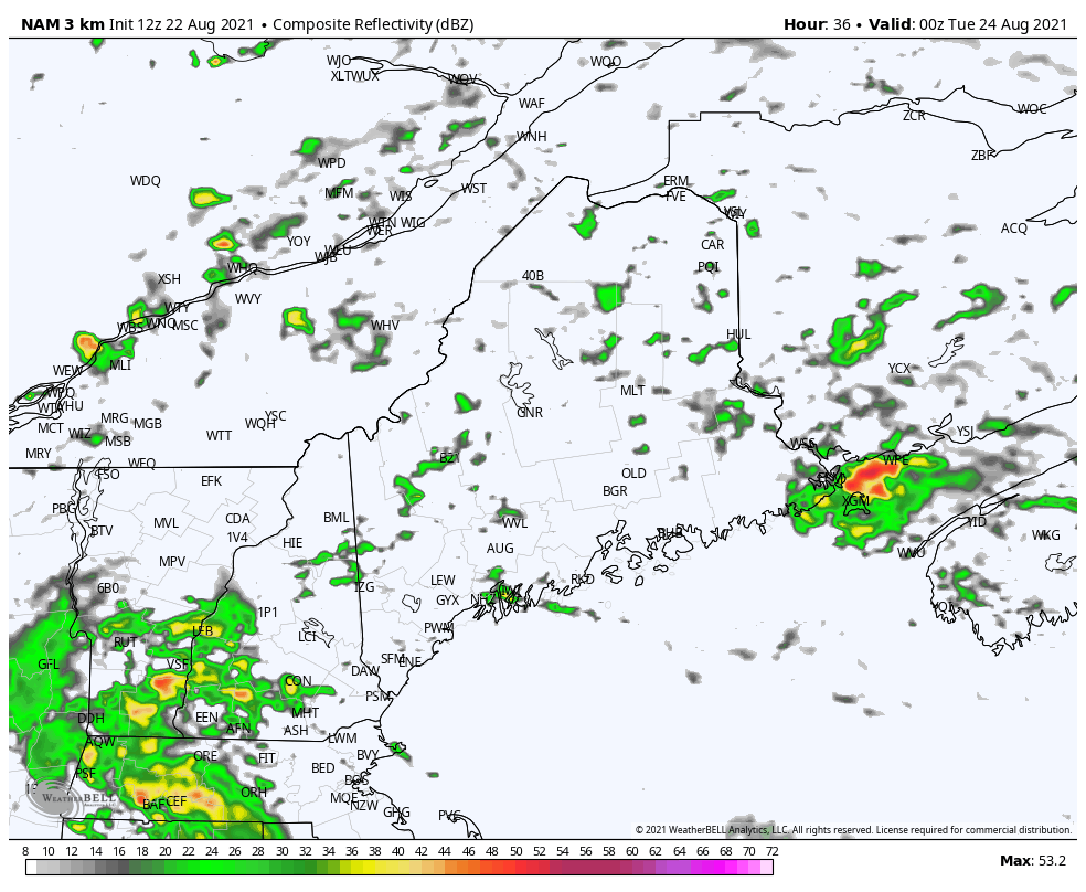 As what is left of Henri begins to move east Monday night, the best chance for moderate to heavy rain occurs early Tuesday for the shoreline areas. Widely scattered showers are possible through the day as the air column clears out. 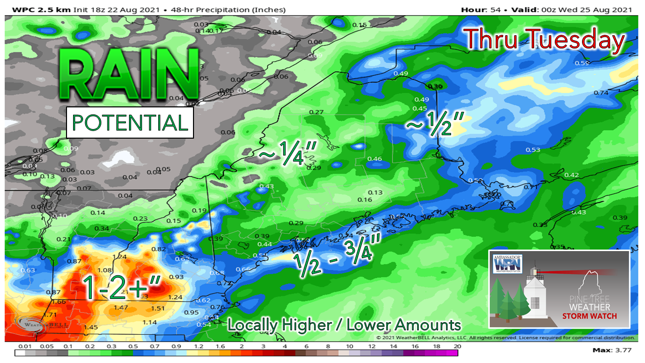 Total rainfall from Sunday night to Tuesday appears minimal overall, with no real concern for interior flooding. Shoreline areas deal with minor coastal flooding around midnight Monday with the astronomical high tide, and perhaps once again with the high tide around 1 AM Tuesday, but the surf will be lowering through the day Monday. A break in the humidity late week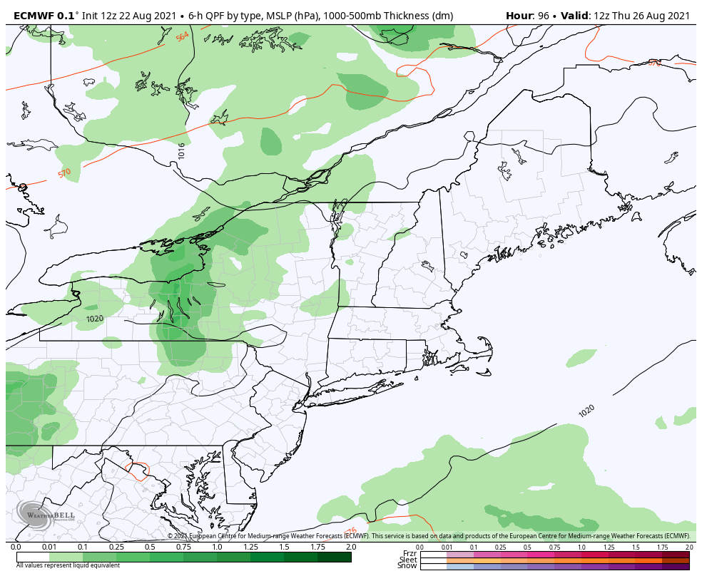 Wednesday is still on track to be a mainly sunny affair with sticky humidity and heat indices into the 90s over a good portion of the region. An arrival of a cold front Thursday brings the chance for showers and storms. The question at this point is how widespread they may be. 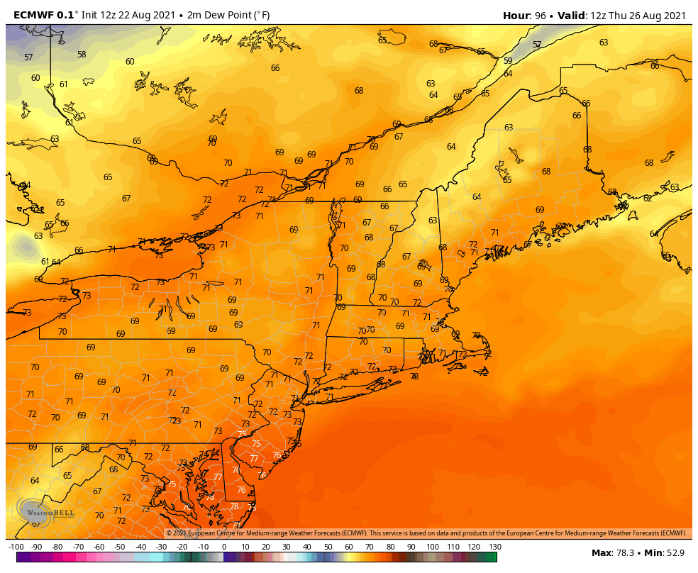 Behind the cold front comes the humidity drop Thursday night into Friday. Saturday looks to be another comfortable day before the dew points creep back up on Sunday as the ridge to the west slides back in. Spot a rip current!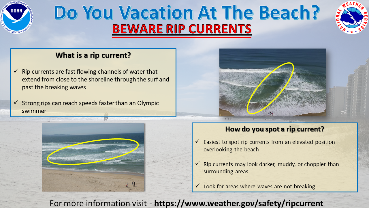 We all love the beach in the summer. The sun, the sand, and the surf. But just because we're having fun, doesn't mean we can forget about safety. Rip currents account for 80% of beach rescues and can be dangerous or deadly if you don't know what to do. It's simple stuff, but we can't take it for granted. Know before you go. Check local beach forecasts before you head to the beach, and always swim near lifeguards. Look for any warning signs or flags. If you're unsure about conditions, ask a lifeguard. And know how to swim before you venture in. If you do happen to be caught in a rip current, stay calm. It won't pull you under - it'll just pull you away from shore. If you try to fight the rip current and swim against it, you'll just get worn out. Instead - float! If you can, wave and yell to get the attention of lifeguards and people on shore to let them know you need help. If you're a good swimmer, swim parallel to shore until you've cleared the pull of the rip current. Swim with the waves, allowing them to push you to shore. If you can, wave and yell to get the attention of lifeguards and people on shore to let them know you need help. If you're on shore and see someone in trouble in a rip current do not go in after them. Instead - call for help! If a lifeguard is not available, throw in something that floats or extend a reaching object, but don't try to be a hero and make the rescue yourself. Even trained lifeguards only attempt a rescue using a flotation device. Rip currents can be dangerous, but if you know your options, survey your situation, and stay calm, you can stay safe and continue to have fun in the surf, sand, and sun. Temperature outlook through FridayRemnants of Henri keep the temperatures down to start the week, but run above average overall through Thursday, then cool down to wrap up the work week. 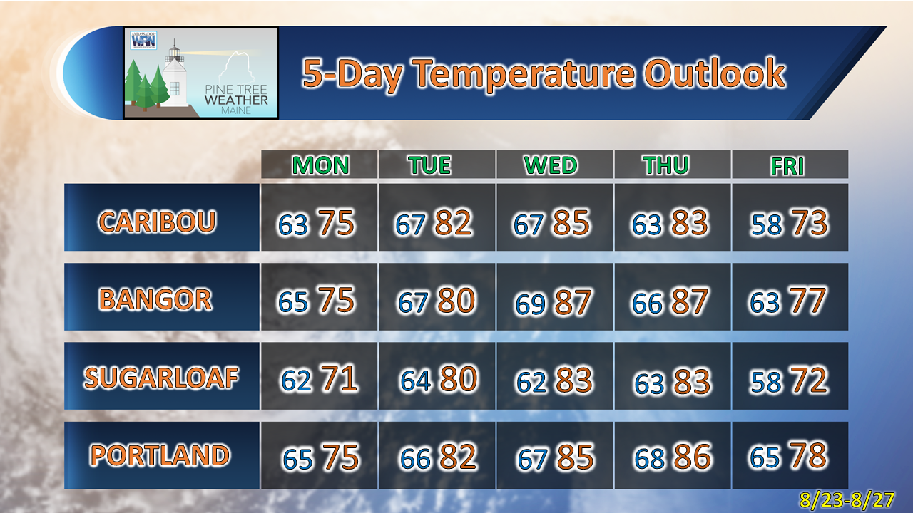 Be prepared to receive alerts and stay updated!
For more information in between posts, please follow Pine Tree Weather on Facebook and Twitter.
Thank you for supporting this community-based weather information source which operates by reader supported financial contributions. Stay updated, stay on alert, and stay safe! - Mike |

Mike Haggett
|