|
Ahead of the forecast I just want to acknowledge the efforts of the summer staff here at PTW. I am incredibly grateful for the work they are putting into the morning Facebook updates, as well as the evening website updates here. Maine is a tough area to forecast as many on the team are realizing. There is a bit of a learning curve going on here to see where guidance is good and where it fails in the day-to-day outlooks given the situation atmospherically. It's always a challenge to look at a different area outside of your own backyard, which is why I rarely ever forecast much than a general idea outside of the region I know. Since I have recently graduated from Penn State, my role this summer has evolved more into mentoring and teaching, which is challenging me in ways I have yet to experience given the number of students involved. There is some great forecasting talent in this group, as has been seen already, which I am incredibly pleased with. While my role has changed, you will see me drop in here from time to time, and you can always find me on Twitter. Rain comes at the expense of the holiday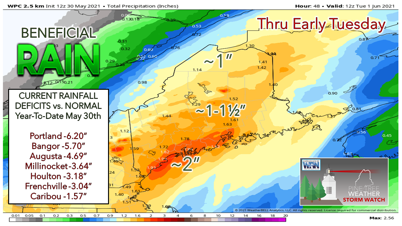 Beggars can't be choosy at this point, and while the timing is terrible for the holiday weekend, there is no question we absolutely need this rain. I can say from my standpoint in Kennebunk that the southern region is close to being parched. The rain received earlier in the weekend helped get the pollen and dust under control, and with more rain coming, it appears to make a solid dent in the current deficits. Heavy rain at times along with a rumble of thunder through Monday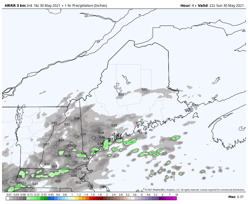 One hour precipitation idea from the 18z (2 PM Sunday) HRRR model shows rain picking up with intensity and spreading north and east from 6 PM Sunday to 8 AM Monday. Rain amounts could exceed ½-1" per hour sporadically and could include some rumbles of thunder in the early morning hours around daylight Monday. Areas of fog appears likely in spots as dew point values rise, which could reduce visibility into Monday. 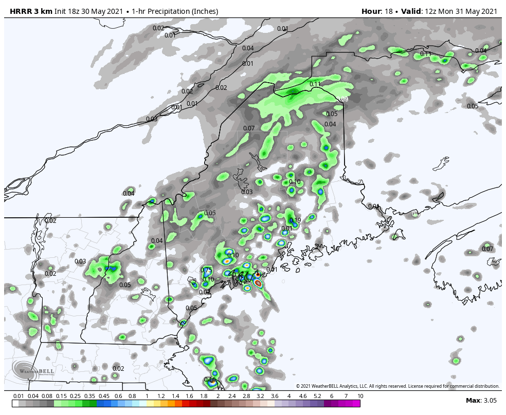 From 8 AM Monday to 2 AM Tuesday, southwestern areas see a bit of a dry slot work in during the morning hours as the main precipitation shield moves northeast. As the surface low moves into the Canadian Maritimes, an upper-low passes through the region, which will touch off scattered showers with chances for thunder through the remainder of the day. Rain ends from southwest to northeast Monday night, clearing The County in the wee hours of Tuesday. Waves are up until midweek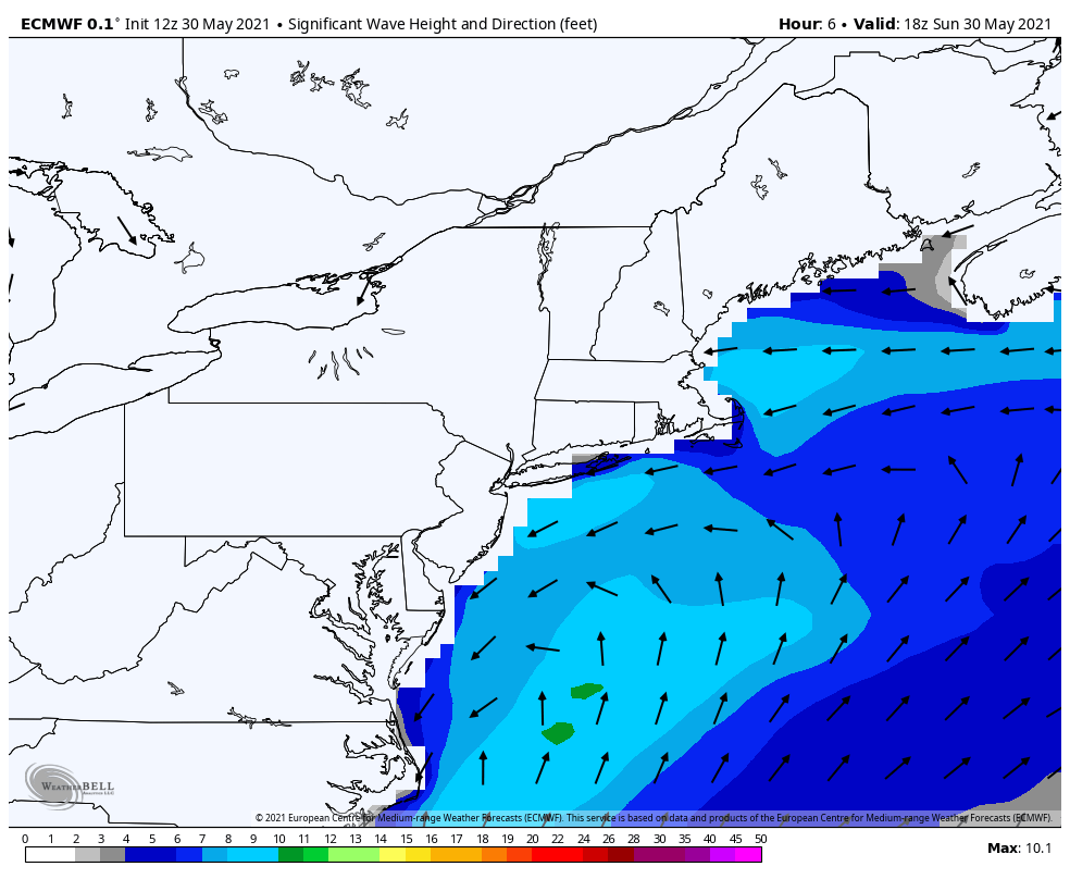 For the mariners and seaside seekers, be advised that the ocean will be churning because of the passing storm through the first half of the week. The waves in the 6-9' range subside into the 4-6' range on Monday then drop to 2-3' range by Tuesday into Wednesday. ► Check out the Marine page here at Pine Tree Weather all summer with current information from several offshore locations as well as links to the latest marine forecasts issued by the National Weather Service. Showers & storms return later in the week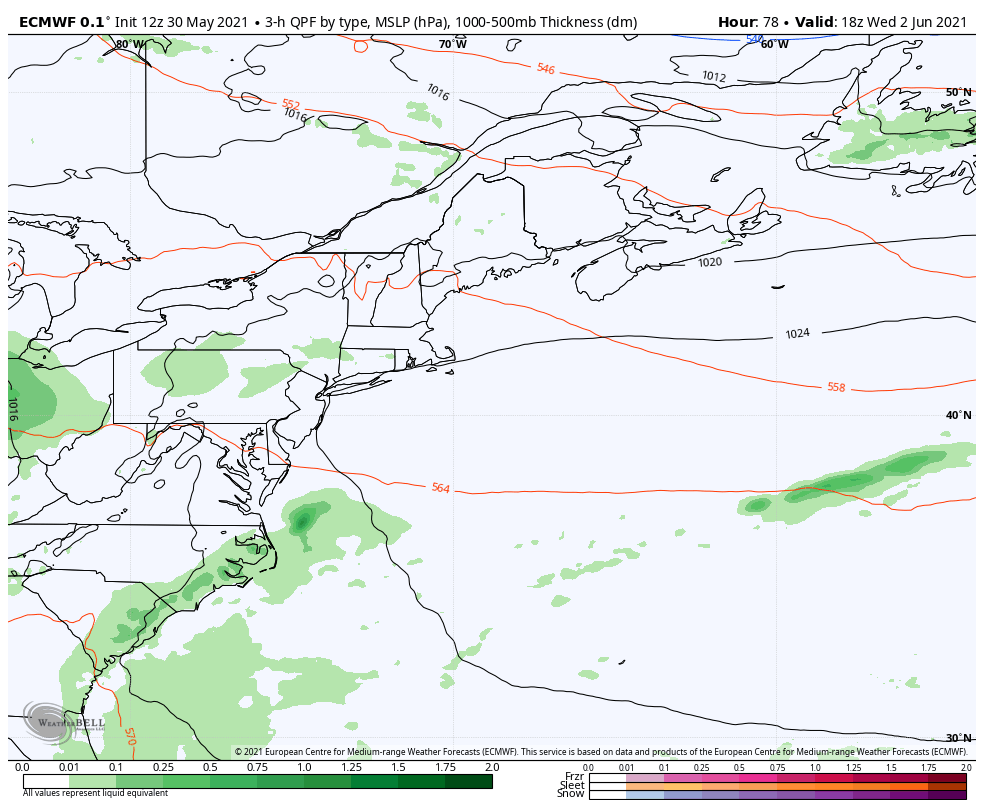 As we head into the second half of the work week, a warm front moves in from the southwest. With the Bermuda High in place, that pumps in more humid air into the region. A trough is on track to dip into the Midwest. With the Bermuda High holding in place, which sets up disturbances to ride along ridge along the east coast. Consequently, showers and storms appear to be in the forecast Thursday and Friday, and possibly into next weekend. Stay tuned for updates on this as the week unfolds. ► Are you planning outdoor activity this summer? Stay on top severe weather potential by checking in with the severe weather page here at Pine Tree Weather with the latest outlooks from the Storm Prediction Center up to three days out, updated every six hours. Temperatures through SaturdayThe average highs and lows anointed into the forecasts to show variances from normal. Northern areas start off close to seasonal average, whereas the rest of the state starts off cool. By the weekend, all areas appear 10°+/- above the norms for highs and lows. 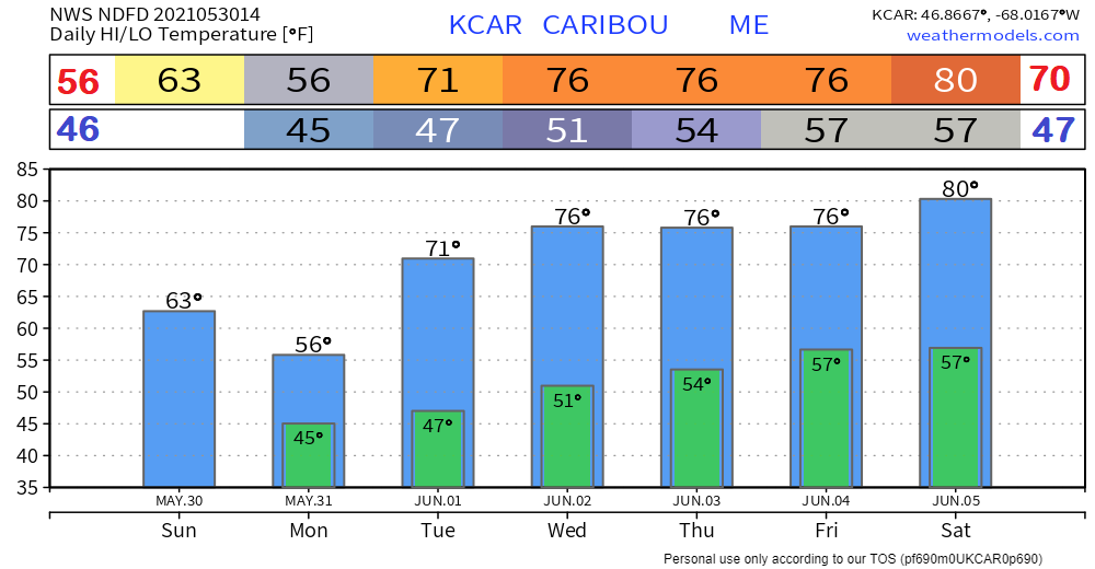 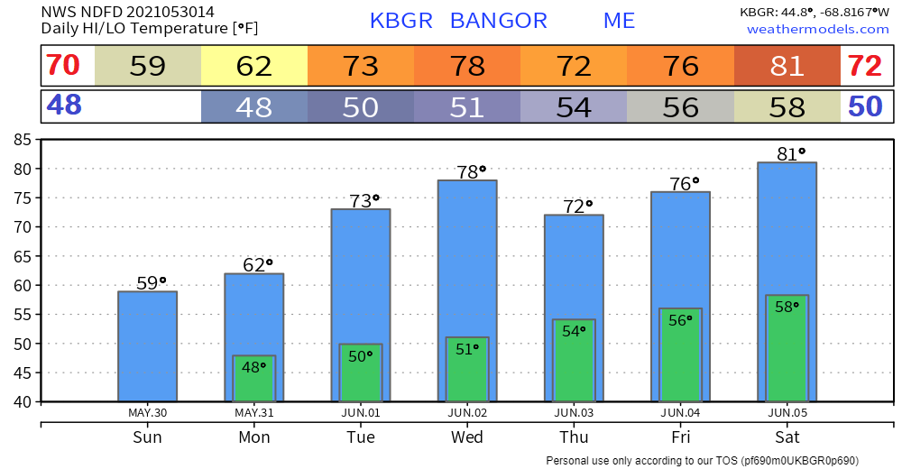 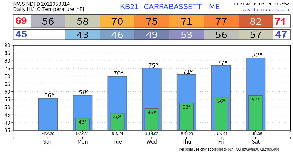 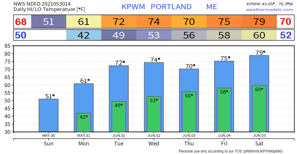 Join the weather community as a storm spotter!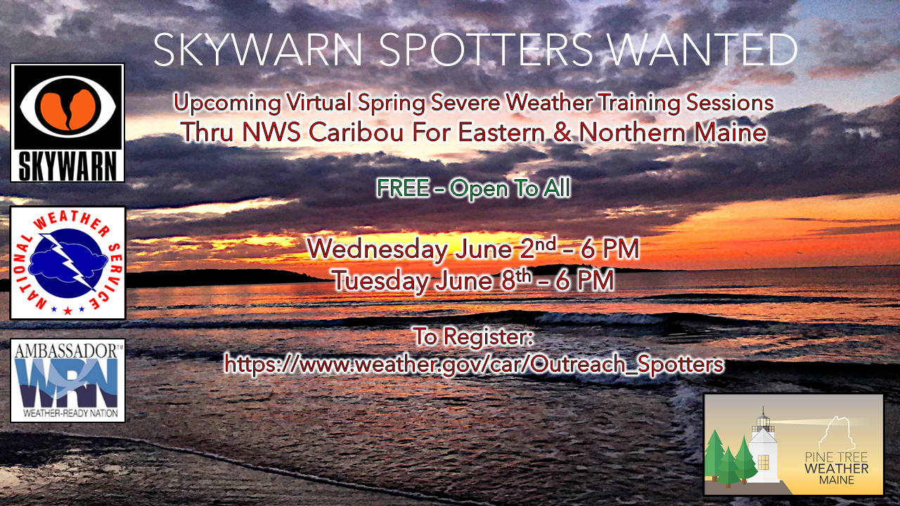 Here's a wonderful way to become active in the weather community and help the broadcast media and forecasters like myself with storm reports. This information is vital during and after an event for forecasting and alerting purposes. I can't tell you how many times I have seen the importance of these reports in the past 9+ years I have been involved. Pine Tree Weather followers have stepped up in the past and participated, and with the readership base continuing to grow, I know there are more out there. This is the spring/summer session which discusses severe weather, what to look for, and how to report it. These sessions run for about 90 minutes. They are fact filled, educational and interesting. You can get the whole family involved from the comfort and safety of home. Once completed, you will get your spotter ID, and will be ready for the season ahead. For those who trained for the winter session, this will complete your full year training. It's important to have both sessions done. The link to register is here ►https://www.weather.gov/car/Outreach_Spotters Be prepared to receive alerts and stay updated!
|

Mike Haggett
|