
Final snowfall idea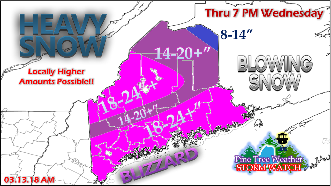 Hopefully you are where you need to be and not planning on going too far, unless you are in Northern Maine where this won't have affects there until evening. This is shaping up to be a classic. I have adjusted the snow amounts. Yes, it's more. Plenty of cold air, plenty of moisture, the right atmospheric dynamics presents this potential. This snow is going to blow around. This is yet another storm that won't be measured in inches, but by feet of drifts. Before I get tweets and Facebook comments saying "We only got 8 inches!" go check your neighbors yard. Some open fields will show little effect, while areas that snow can build up around will appear buried. If this was straight rain, we're looking at 1.5 - 2.0"+. Snow fall amounts may be locally higher in mesoscale banding. This also may rob some snow totals from other areas. That is the way these storms work. I thought about pulling the trigger on this snow map Monday afternoon, but I wanted to make sure all the pieces of the storm fell into place. I am confident enough now to reveal it. So when can clean up and recovery begin? As I mentioned yesterday, this is a two day event for most areas. Snow tapers off from southwest to northeast Wednesday into Wednesday evening. The storm will weaken, but it won't be going far due to blocking. Snow showers from it are likely to return on Thursday which could bring a dusting to an inch or two of additional accumulation. Blizzard conditions for the coastal plain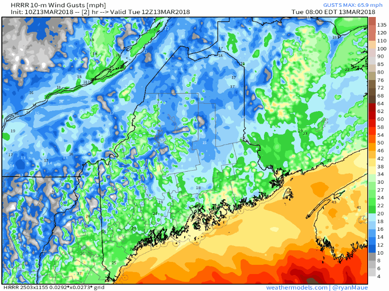 HRRR short term model here looking at wind gusts certainly shows a gusty affair. Blizzard warnings have been issued for coastal areas for the entire shoreline from Eastport to Kittery. You may not live in that zone, but that isn't to say whiteout conditions won't occur. The shear volume of heavy snow in the 1-3" range with even a light wind is enough to cause problems. Add in 20-40 mph gusts and that will be enough to cause travel problems. Power outages are likely to be an issue with the heavy snow and wind. Wind appears to settle a bit over western and southern areas by late evening, but speeds in the 15-25 mph range are likely to continue statewide through Wednesday. Snow will continue to blow and drift even after it gets moved. Final thoughtsI keep saying with every storm there is always the element of surprise, and this one is no different. The unexpected occurs. This could get out of hand, like any other big storm. It's not going to surprise me to see some isolated areas receive 30-40" of snow out of this, with the Katahdin region and the ski hills the likely recipients. Interior York County, MidCoast and DownEast areas could be in the 24-30" range. Snow to water ratios are going to vary.
This winter started off with a bang with the late October Gale. This winter is going to end with a bang as well. This storm may not be the final parting shot. We have plenty of March still to go, and for us that have lived here a long time, April has been known to bring solid events as well. To those weary of winter, hang in there. For snow lovers, have a blast. Stay in touch with NWS Gray and NWS Caribou for the latest for your region. Coverage continues on Twitter all day. Godspeed. - Mike |

Mike Haggett
|


