
Entering the teeth of the storm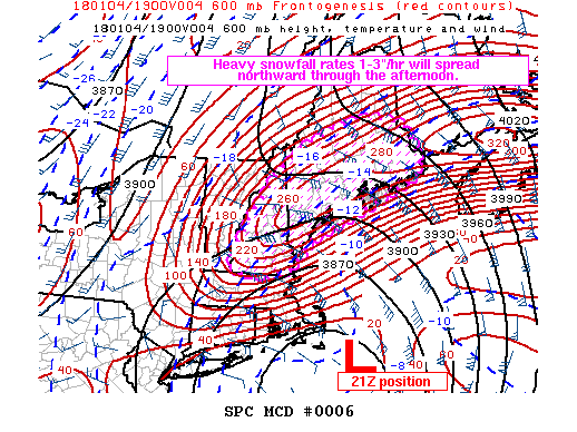 FROM THE STORM PREDICTION CENTER: Mesoscale Discussion 0006 NWS Storm Prediction Center Norman OK 1034 AM CST Thu Jan 04 2018 Areas affected...NH into southern and central ME Concerning...Heavy snow Valid 041634Z - 042130Z SUMMARY...Heavy snowfall rates (of at least 1"/hour) are spreading northward across New Hampshire and through southern into central Maine through the afternoon and early evening. Higher rates of 2-3"/hour expected into PWM (Portland) between 19-22Z (3 PM - 5 PM) and MLT (Millinocket) between 21-00Z (4 PM - 7 PM) . In addition to heavy snowfall rates, the intensifying storm system will result in strengthening winds to produce blizzard conditions across coastal regions of New England. DISCUSSION...Heavy snowfall rates will continue to spread to the west and north across NH into the early afternoon associated with a snow band extending from western CT to southern NH/southwest ME per mosaic radar. A second frontogenetic (very heavy snow) band is expected to develop by early afternoon from northeast MA to coastal and southern ME. The forcing for ascent attendant to the second frontogenetic (very heavy snow) band is expected to enhance snowfall rates into the 2-3" per hour range by 19Z across southern ME and then by 21Z into central ME as this band shifts poleward. Forecast soundings suggest the increase in upward vertical motion should occur within the dentritic-growth zone, enhancing snowfall rates, while steepening midlevel lapse rates could support upright convection/thundersnow potential. The heavy snowfall rates are associated with a strong, dynamic winter storm affecting New England through today into this evening. Further deepening of the surface low is expected (1 MB/hour) through 21Z, as it tracks to the north-northeast, reaching the Atlantic waters southeast of Cape Cod (approximately 41N/69W). ..Peters/Karstens.. 01/04/2018 MY DISCUSSION: I tried to "humanize" this discussion from SPC to give you and idea of what to expect. The "increase in upward vertical motion should occur within the dentritic-growth zone, enhancing snowfall rates, while steepening midlevel lapse rates could support upright convection/thundersnow potential" validates the 700 mb vertical velocity graphic I displayed in my earlier update. What all this scientific gibberish says it is going to dump large volumes of snow, and I expect that the 2-3" estimate may be a bit conservative. This storm appears to land in Nova Scotia around 948 mb which makes this storm more powerful than the Late October Gale, The Perfect Storm, and any of the recent blizzards the region has experienced. Updated Timeline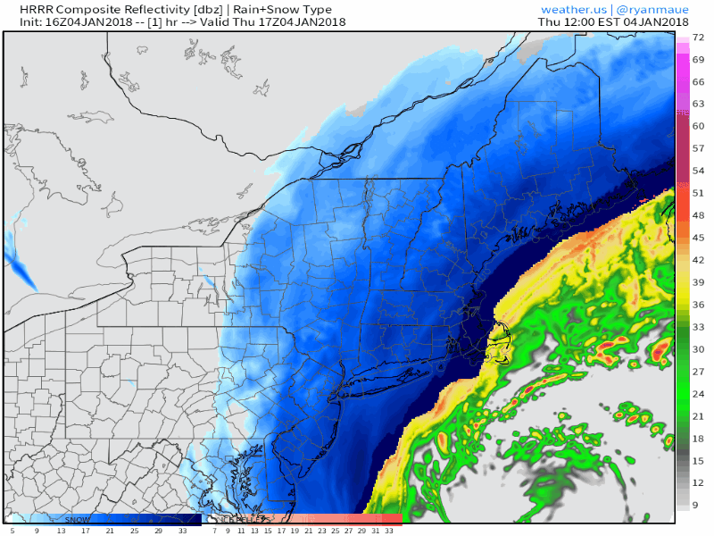 Presented here is the 16z (11 AM) HRRR model idea on how this will play out through 4 AM Friday. The coastal front that I discussed is likely to cut down on snow totals for DownEast areas and central Washington County. Heavy snow begins to taper over southwest areas by around 10-midnight, Bangor by 3-5 AM, with snow continuing in The County until Friday morning. Be aware that snow showers will continue into Friday statewide as the next arctic front moves in. Wind still a concern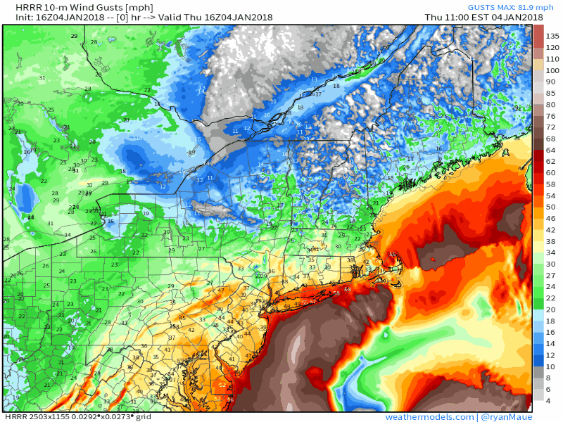 This is also from the 16z (11 AM) HRRR model run. Many areas will hit 30+ mph. I think this underestimates the wind speeds for the shorelines and southern and eastern interior areas. Even after the storm passes, the wind will continue to blow snow around into Friday night. Power outages remain a concern. Snow totals on track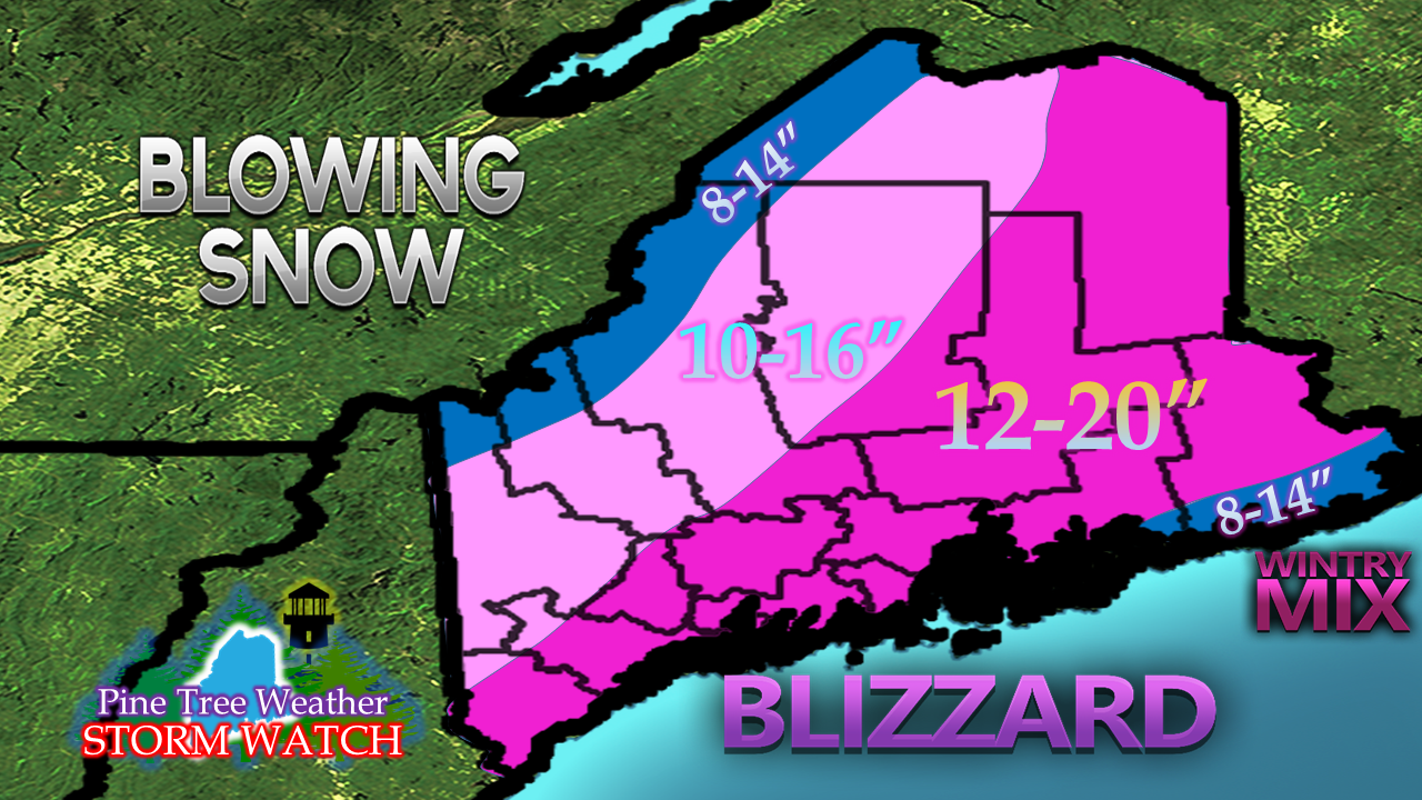 I see no reason to change my snowfall idea posted earlier. The snow is coming in at a high ratio, and with the heavy snow bands still to come, this will be close. Again, this storm won't be remembered by measurement in inches but by feet of drifts. . Where I may bust is in interior Washington County if the coastal front works in deeper. 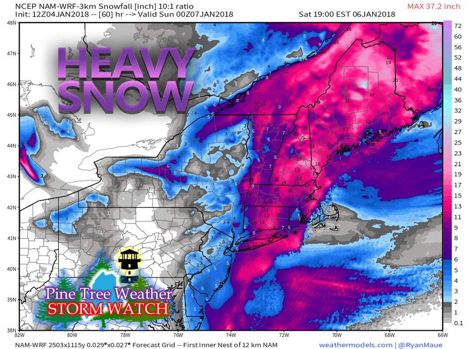 The 12z (7 AM) NAM-WRF model idea, if it verifies, may indicate that my earlier call was underdone. We shall see. Outlook through the weekend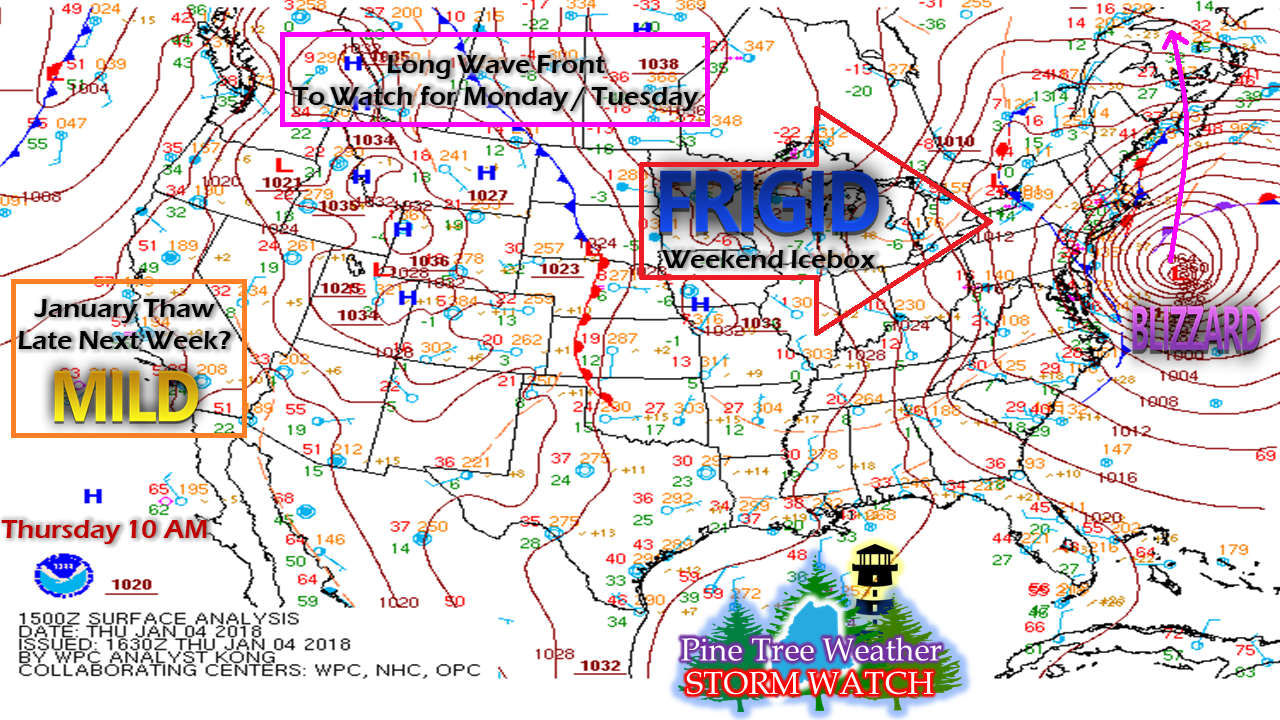 This is surface analysis from the Weather Prediction Center as of 10 AM Thursday. After the blizzard passes by, the coldest air yet arrives for the weekend. A long wave front arrives to start the week. Monday appears to have light snow region wide. Tuesday is a bit of a question mark. Guidance is playing around with the idea of a possible storm to develop along the front as it crosses into the Atlantic, which may impact the region. Models are also hinting at a possible warm up for the region late in the week. The strong ridge over the west coast that has funneled cold air into the area for the past few weeks shows signs of a possible collapse, which would allow the cold air to retreat north, and give the region a chance to thaw out. Time will tell... stay tuned.
The 5-Day Outlook has been updated. You can click on the tab on the menu to get you there. For all the newcomers, thank you for joining Pine Tree Weather. You may not like the weather, but the goal is that you will like the way it is presented to you, without the hype or any bias. I work hard to be honest, accountable, and work with integrity. As I approach my seventh year of forecasting, I would like to thank everyone who has joined me and believed in me as I continue to develop. Hang in there... stay on alert for surprises! - Mike |

Mike Haggett
|


