Pine Tree Weather
  • DISCUSSIONS
  • DONATE
  • MAPS
  • NWS BRIEFINGS
  • SATRAD
  • MARINE
  • SNOW / ICE OUTLOOK
  • RAIN OUTLOOK
  • CPC OUTLOOK
  • Kennebunk
  • OBSERVING WEATHER
  • Who We Are
  • My Photography
  • DISCUSSIONS
  • DONATE
  • MAPS
  • NWS BRIEFINGS
  • SATRAD
  • MARINE
  • SNOW / ICE OUTLOOK
  • RAIN OUTLOOK
  • CPC OUTLOOK
  • Kennebunk
  • OBSERVING WEATHER
  • Who We Are
  • My Photography

Breezy and cooler Tuesday; wintry mix to rain for Thursday

12/14/2021

Comments

 
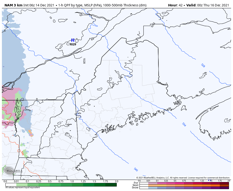
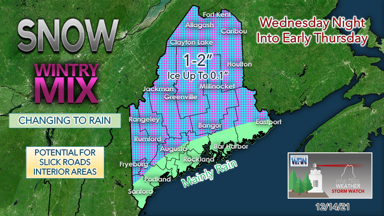
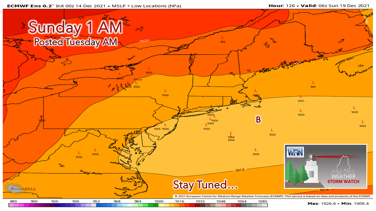
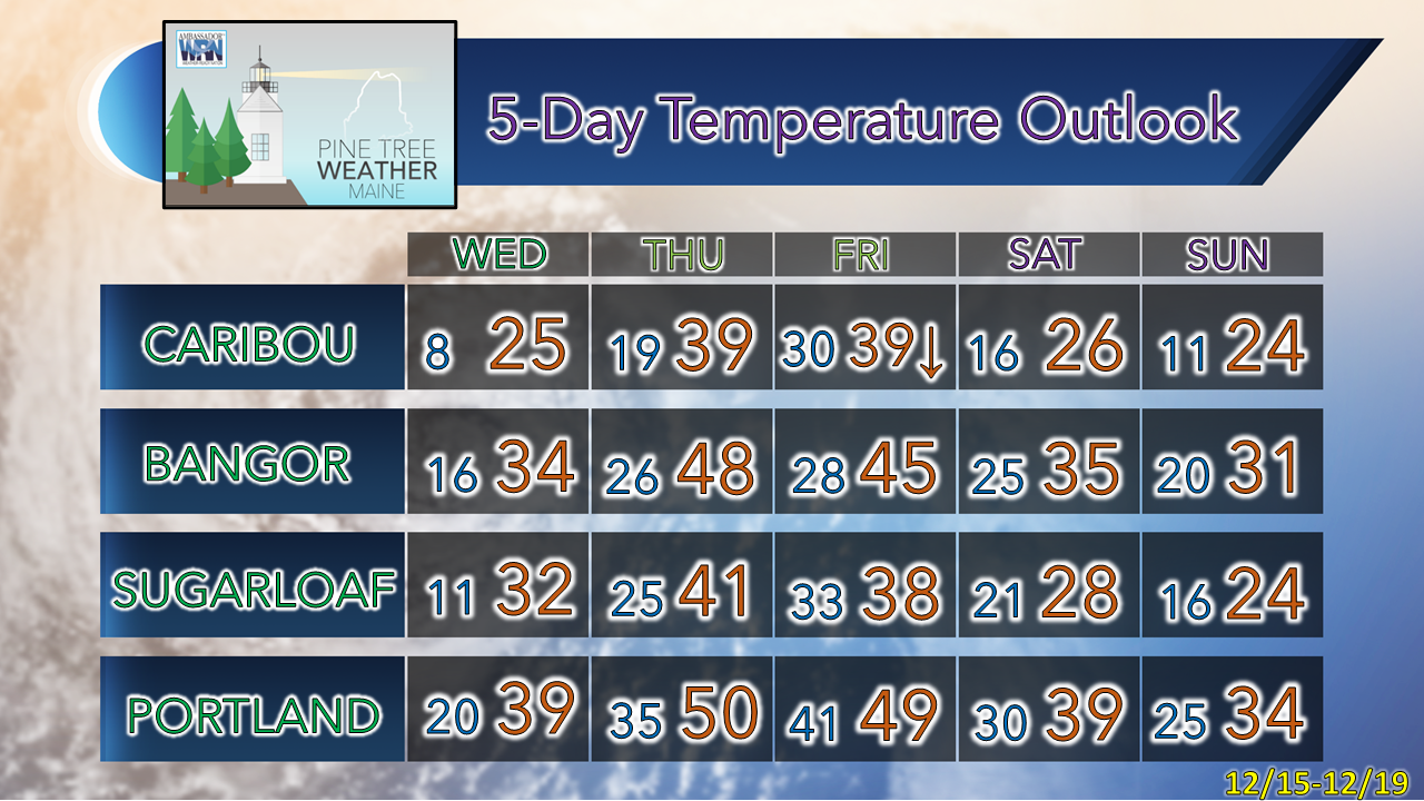
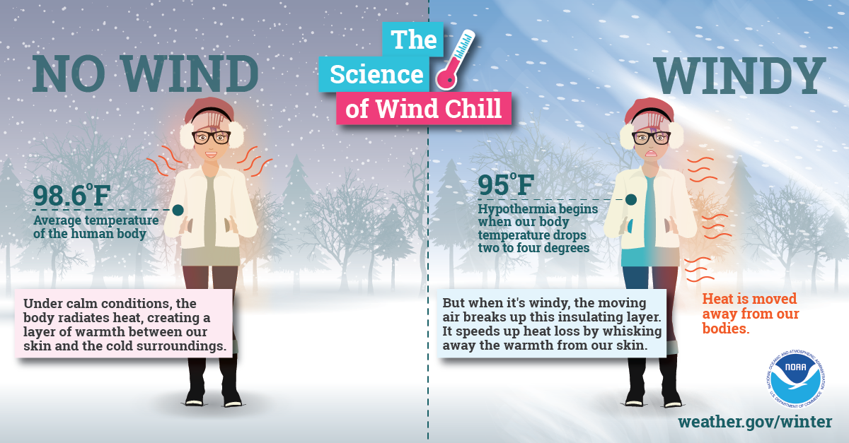
Ahead of the forecast I would like to say thank you to those who have made financial contributions. If the Patreon donors maintain their pledges through the year, I have reached the goal to pay the bills for 2022.  I appreciate this immensely. I don't draw any sort of salary here to this point. All the funding from you folks over the past three years goes into weather data, website, graphics, technology, product improvement and for the college meteorology students who work with me. The tip jar will remain open for those who find it in their heart to chip in a few bucks throughout the year.  Your support means the world to me, and I thank you for it. 

Another breezy day

Picture
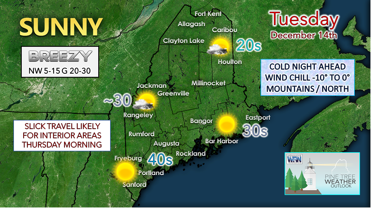
A weak cold front passes through the region today and the breeze increases on the backside of it as high pressure moves in. Gusts in the 20-30 mph range are likely for most areas. The mountain valleys may see gusts reach 35-40 with the downslope. With the breeze, knock off 5-10 degrees off the temperature for the wind chill.  Any clouds clear out Tuesday night, and temperatures plummet. There could be enough of a breeze to send wind chill values below zero in the north country, single digits, and teens above elsewhere. It may be a good idea to throw another log or two into the stove before bed. 

After a chilly start on Wednesday, temperatures rebound with similar high temperatures. It is likely to feel warmer with less wind expected. Clouds appear likely to increase over southwestern areas as warm air moves in aloft ahead of the next system for Thursday.

Wintry mix and rain on the way
​Wednesday night into Thursday

Picture
Wednesday 7 PM to Thursday 1 PM - The good news is there isn't a whole lot of liquid equivalent precipitation associated with the warm from moving in. The general idea is for roughly ¼" +/- overall. As I have mentioned in the past couple of days on Facebook, cold air damming will be the concern for ice over the interior with this one, and that remains the case. 

Precipitation in the form of light snow is expected to move into western areas on Wednesday evening. It is on track to move across the state by the wee hours of Thursday. It appears at this point most of what is expected to fall from the sky will be on the ground by daylight on Thursday. As we have seen here recently, there is potential for areas of patchy fog and drizzle (freezing or not) to pop up Thursday morning. The warm front is expected to move well north during the day, with sun breaking out for all but northern areas Thursday afternoon. This will drive temperatures up, clean up any ice or snow build up, and it appears to stay above freezing well into Thursday night.  

The daily high temperatures for northern areas for Friday are expected to happen by midnight and then fall through the day as a cold front passes through from the west. A breezy day helps dry the area out and brings cooler temperatures in for the weekend.
Picture
The main concern for slick spots for untreated surfaces appears to be Thursday morning. Any snow that falls ahead of the ice will help with traction, but for most, this is more of a nuisance storm than it will be impactful. Northern areas have a better chance of seeing 1-2" of snow. Western areas may struggle to see an inch before the changeover. 

Weekend storm has drifted south... for now

Picture
Friday 7 PM to Sunday 7 PM - Most of the deterministic ideas for the weekend storm have drifted south and the pattern is setting up for it to be flatter and less impactful. High pressure to the north may act as a block and keep much of the precipitation over the Mid-Atlantic and Southern New England. 
Picture
Looking over individual ensemble ideas makes me think that it may be a bit early to write off any sort of potential just yet. Southern areas have the best chance, albeit a low one, to see snow at this point.  Time will tell if it drifts northward. 
Picture

Picture
Extremely cold air affects millions of people across the United States every winter and even into parts of the spring. This Arctic air, together with brisk winds, can lead to dangerously cold wind chill values, which can cause your body to lose heat quickly. weather.gov/safety/cold-wind-chill-chart

Be prepared to receive alerts and stay updated!

Picture
​BE PREPARED WITH A NOAA Weather Radio.
​
​For $20-$40, it could provide vital information to you when you need it. The weather bands are standard on most public safety scanners, and newer scanner models. Weather radios can be programmed for auto alert. Click here for more information.

​​► ► For the latest official forecasts, bulletins, and advisories, please check in with the National Weather Service in Gray for western and southern areas, or Caribou for northern and eastern parts of Maine.
Picture

Picture
​For more information in between posts, please follow Pine Tree Weather on Facebook and Twitter. 

​Thank you for supporting this community-based weather information source which operates by reader supported financial contributions. 
​
​- Mike
Comments
    Picture

    Mike Haggett
    Kennebunk, ME

    Certified Weather
    Forecaster
    Penn State '21

    American Meteorological Society

    National Weather Association

    Weather-Ready Nation 
    Ambassador
    ​
    ​SKYWARN-CWOP

    Matthew 19:26


    Support
    Pine Tree Weather

    DONATE

    Picture

    Picture

    Picture

    Picture

    Picture

    Picture

    Picture

    Picture

    Picture

    Picture

    Archives

    January 2023
    December 2022
    November 2022
    October 2022
    September 2022
    August 2022
    July 2022
    June 2022
    May 2022
    April 2022
    March 2022
    February 2022
    January 2022
    December 2021
    November 2021
    October 2021
    September 2021
    August 2021
    July 2021
    June 2021
    May 2021
    April 2021
    March 2021
    February 2021
    January 2021
    December 2020
    November 2020
    October 2020
    September 2020
    August 2020
    July 2020
    June 2020
    May 2020
    April 2020
    March 2020
    February 2020
    January 2020
    December 2019
    November 2019
    October 2019
    September 2019
    August 2019
    July 2019
    June 2019
    May 2019
    April 2019
    March 2019
    February 2019
    January 2019
    December 2018
    November 2018
    October 2018
    September 2018
    August 2018
    July 2018
    June 2018
    May 2018
    April 2018
    March 2018
    February 2018
    January 2018
    December 2017
    November 2017
    October 2017

    RSS Feed

Proudly powered by Weebly