
Sunnier for Saturday and Sunday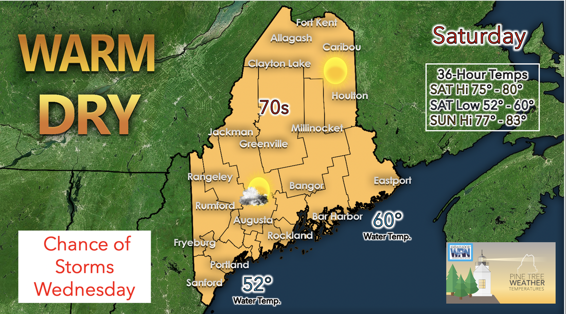 As Tropical Storm Elsa retreats by Saturday morning a high pressure system moves into the area brining with it a warm and drier air mass. Therefore, temperatures are expected to be higher for the day Saturday with minimal cloud coverage and dry conditions across Maine. High temperatures for Sunday are likely to fall within the mid 70s to 80s range and will remain in this range along the interior right up to the coastline. However, winds will be weak enough to allow for sea breeze to set up for the afternoon keeping areas along the coast slightly lower. As for the daily low temperatures, Saturday night is forecasted to see temperatures drop as low as 50 degrees in the mountains and hover within the 55-60 degree range elsewhere. 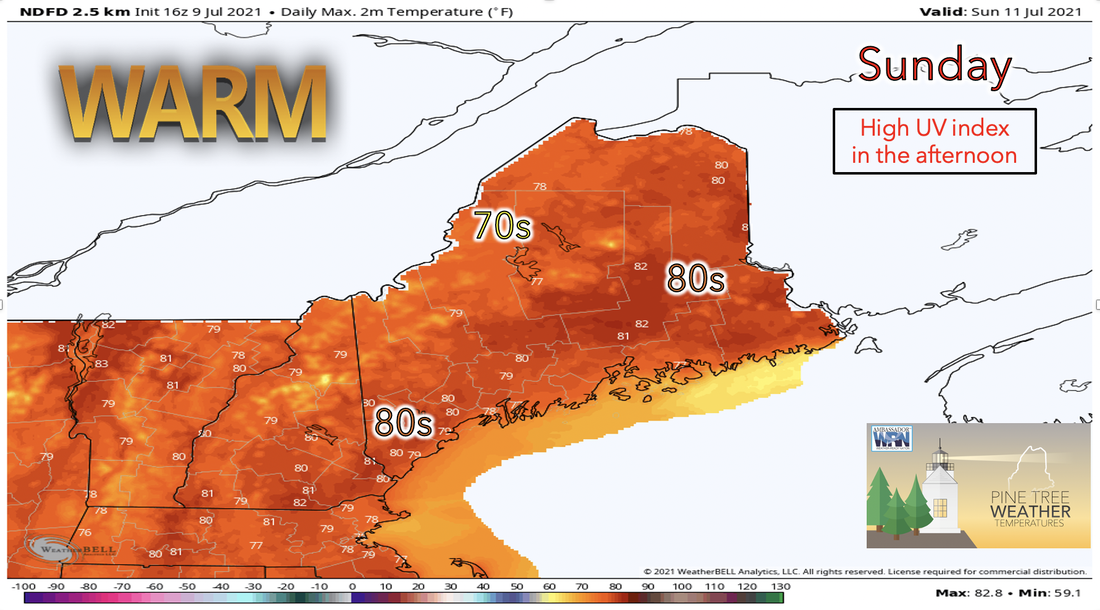 Sunday will be very similar to Saturday with temperatures a bit higher than they were on the previous day. Skies are expected to remain sunny throughout most of the day and humidity should remain minimal giving way to another drier day on Sunday. High temperatures for Sunday are predicted to lie within the upper 70s in the northern and western areas while temperatures creep into the low 80s for the southern and eastern parts of the state. This dry and warmer weather pattern is quite different than what was experienced toward the end of this past week. Dry weather beginning the week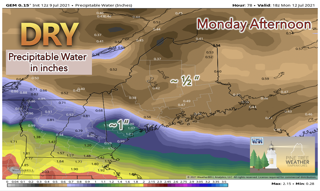 Monday will continue the warm and dry pattern from this weekend. For most of the state conditions will be dry and sunny with the amount of precipitable water in the atmosphere being less than half and inch. This dry pattern will be present in all areas across the state except for the very southern corner of Maine were the amount of precipitable water will hover around 1 inch. This amount of moisture to be seen Monday is likely due to the expected chance for showers in this region. Temperatures for Monday are forecasted to be in the high 70s to low 80s. Dew points for the southernmost corner of the state are expected to be in upper 50s north to low to mid 60s south. This increase in moisture is likely only the beginning of a moist pattern for the week ahead. Rain Returning Wednesday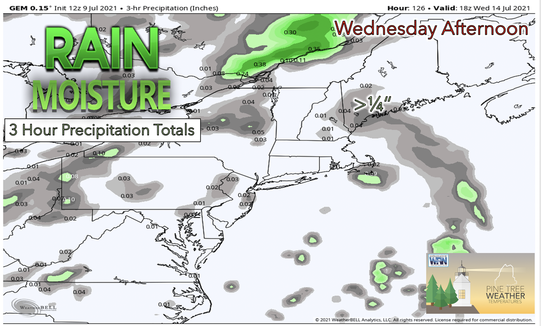 Wednesday will kick off a rainy and humid pattern that will likely last through the end of the week. Both southern and northern areas are likely to see potential for rain showers and possibly storms by Wednesday afternoon as a warm front moves in and shortwaves dominate, high moisture levels will also aid in convective potential. High temperatures for Wednesday are forecasted to stay within the mid 70s to low 80s while dew points are likely to be in the 60s with southern areas reaching the high 60s. Therefore, the air across most of the state will most likely feel wet and sticky starting Wednesday and into the end of the upcoming week. Wet and Warm midweek through Saturday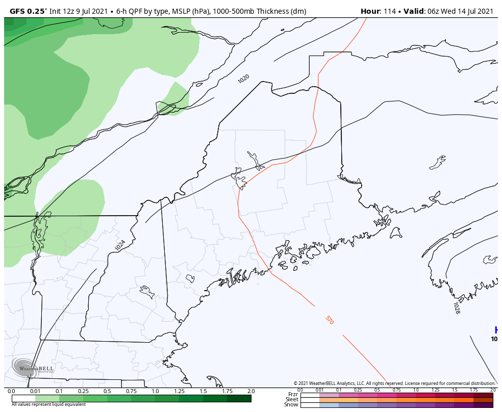 Starting midweek and continuing into the weekend moisture and wet weather become the norm for each day with chances for storms arriving each afternoon. The abundance of shortwaves in the pattern and cycling upper level flow are the reason for this unsettled pattern along with warm temperatures and high dew points each day. Temperatures through the end of the week will be mostly static and remain in the near 80s for the south and decrease to the mid 70s as you move northward. Dew point temperatures will remain in the 60s range through the end of the week with little variation day to day. Remember to keep an eye out for quickly developing thunderstorms as there is potential for their development in the afternoon Wednesday through Friday. CoCoRaHS  Ever wanted to take rain or snow measurements? Join CoCoRaHS or Community Collaborative Rain, Hail, and Snow Network. This volunteer network of observers measures precipitation from their backyards. Any age can volunteer. Data is used by NWS meteorologists to help with forecasts. www.cocorahs.org Weather outlook through next weekTemperatures are seasonally cooler starting Friday and begin to increase starting Saturday. This warming trend is expected to continue through the end of the week ahead. As temperatures increase so will dew point temperatures. Dew point temperatures begin to reach the 60s range by this upcoming Wednesday which will make for a relatively humid second half of the upcoming week. 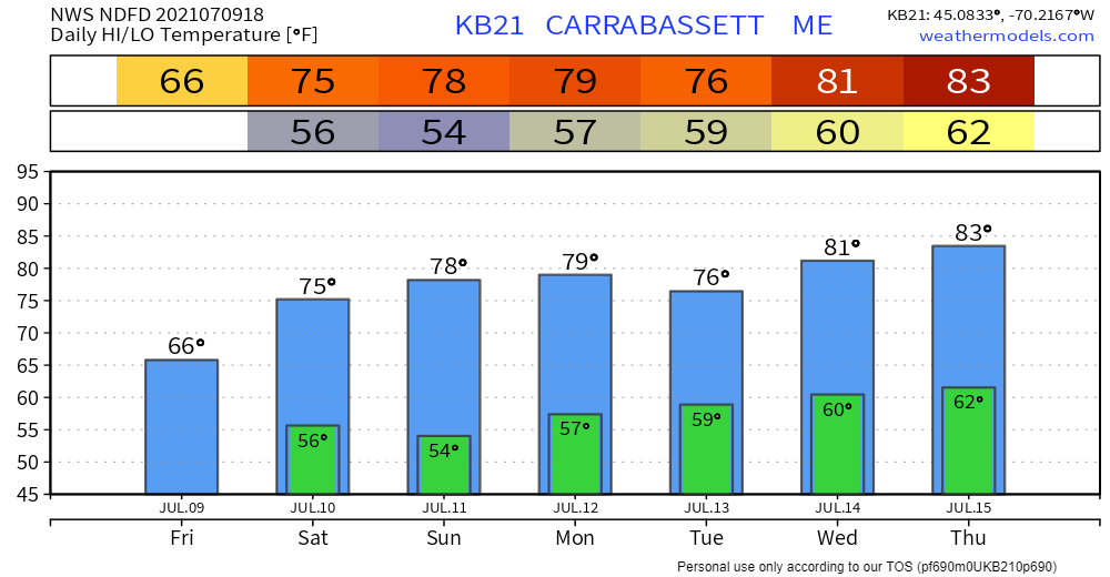 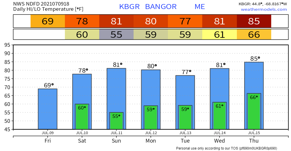 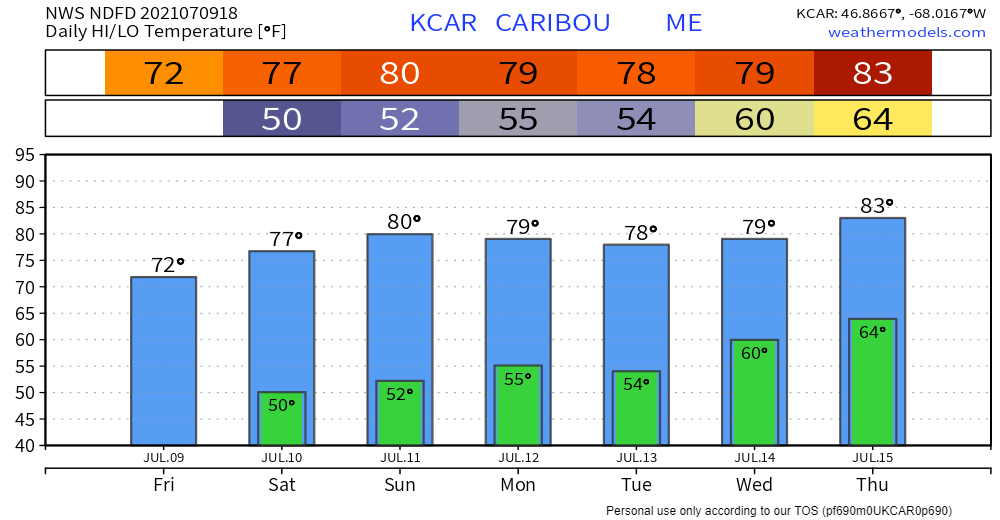 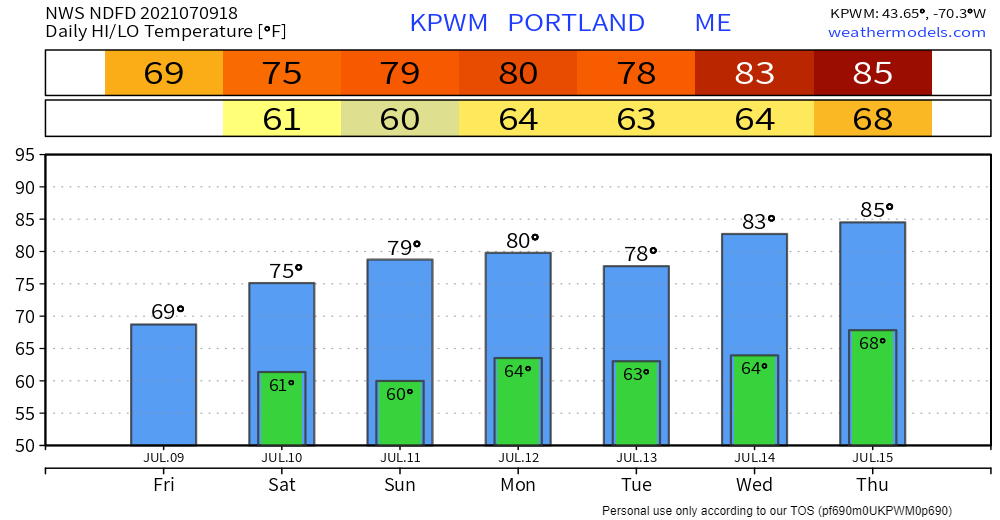 Be prepared to receive alerts and stay updated!BE PREPARED WITH A NOAA Weather Radio. For $20-$40, it could provide vital information to you when you need it. The weather bands are standard on most public safety scanners, and newer scanner models. Weather radios can be programmed for auto alert. Click here for more information.  ► ► For the latest official forecasts, bulletins, and advisories, please check in with the National Weather Service in Gray for western and southern areas, or Caribou for northern and eastern parts of Maine. 
|

Mike Haggett
|


