Low temperatures dip into the 40s and 50s tonight into Friday morning, clouds will slowly increase overnight 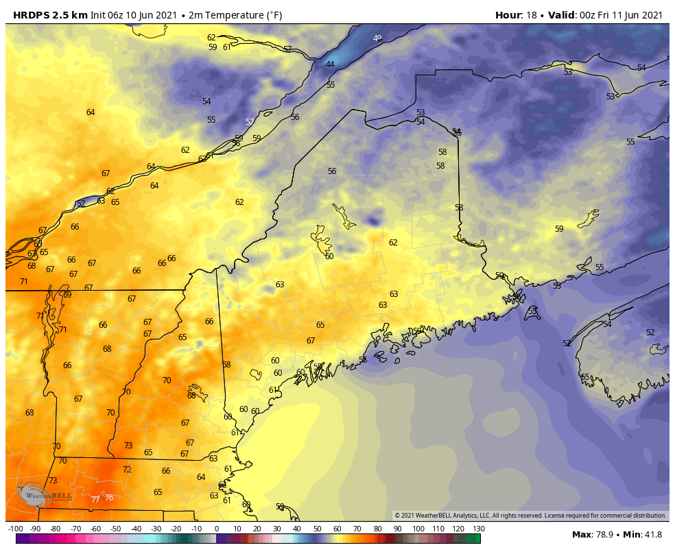 As the cooler air mass continues to move in, temperatures tonight will drop into the 50s and some 40s through the mountains with mostly clear skies to start before clouds move in overnight. For our Friday, clouds and the potential for precipitation will take temperatures a step down from Thursday’s highs. Highs on Friday should be near to slightly below average with temperatures just in the 60s, some spots across the interior could hit the 70°F mark. However, the sea breeze may prevent temperatures from reaching the low 60s along the coast. Showers will clear out early on Saturday allowing for skies to be mostly sunny with temperatures reaching the 70s across much of the state, another sea breeze will set up later during the day. The flow becomes more zonal on Sunday, with temperatures remaining in the 70s and low 80s. Sunday appears to be the warmest day of the weekend before some unsettled weather moves in to start the next workweek. Intermittent rain showers Friday through Monday, but drier than average conditions will persist into next week 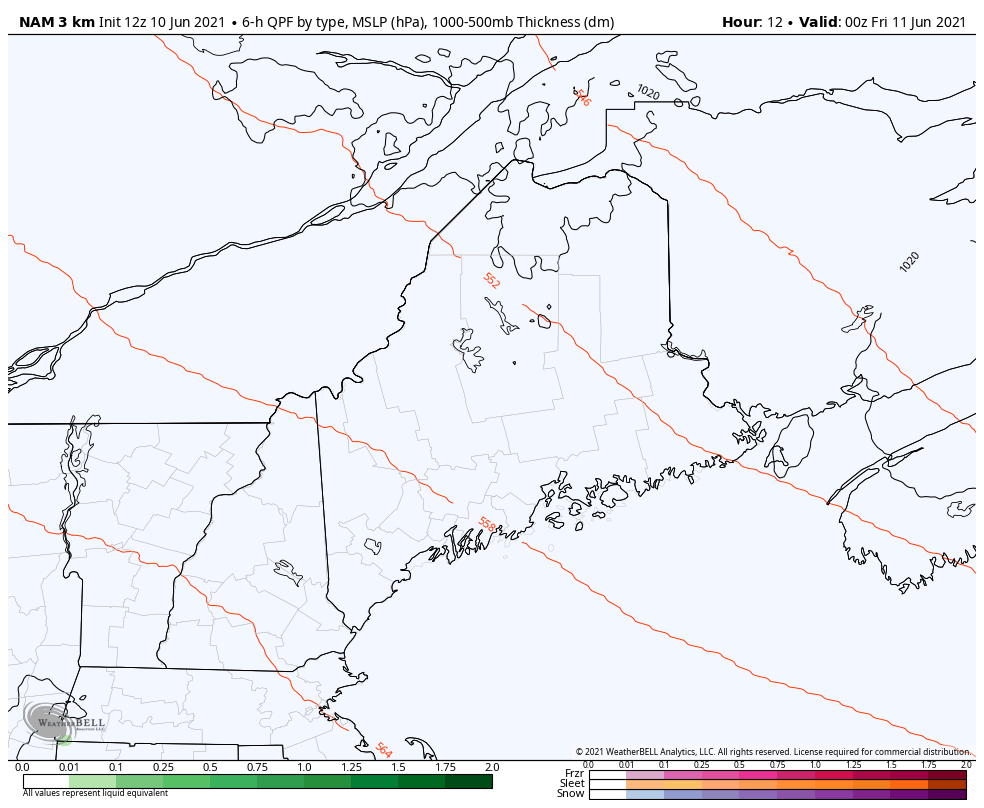 High pressure will remain in control for our weather Friday morning before a disturbance dropping south from Canada will bring the potential for showers late Friday and into Friday night. The region is under a NW flow aloft with shortwaves running through the flow. Models are still not fully agreeing, and there is still some uncertainty on rainfall amounts. Most of the high-resolution models are dry, but the global models and ensembles suggest some passing showers are possible mainly over the SW portions of Maine. For now, there is a slight chance for popup showers in the afternoon and overnight hours into Saturday morning. Saturday and Sunday remain mostly sunny allowing for temperatures to warm up nicely. More significant rainfall comes Sunday afternoon and into Monday, so stay tuned in for updates throughout the weekend! Winds diminish tonight but increase once again for Friday 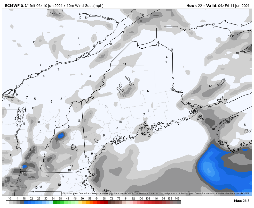 There is a special weather statement from the National Weathers Service for the remainder of the day today for an Elevated Fire Weather Danger. A very dry air mass and breezy conditions will combine with dead and dry fuels such as grass, leaves, and twigs to create an elevated fire danger across most of interior Maine (extra caution should be taken to prevent wildfires). Nearby high pressure should allow for winds to diminish tonight. Winds will drop back to calm/light overnight before increasing to 5-15 mph and gusting up to 25-30 mph coming from the southeast on Friday. For Saturday, winds will be relatively calm at around 5-10 mph, but another sea breeze sets up allowing for cooler conditions along the coastal regions. Winds begin to increase and gust once again Sunday afternoon as the next disturbance makes its way into our region. Drought monitor update 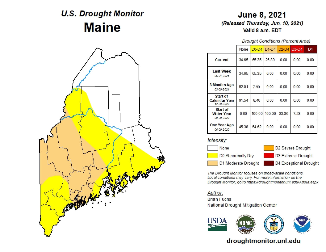 Temperatures for the week were around 8-12 degrees above normal. Precipitation was also spotty with most areas remaining dry. Moderate drought conditions were expanded over western Maine with abnormally dry conditions persisting from much of the state. Over the next 5-10 days, temperatures will return closer to average with spotty chances of rain showers. However, near to below average precipitation is anticipated for the northeast which will limit any relief or impact on our drought levels. 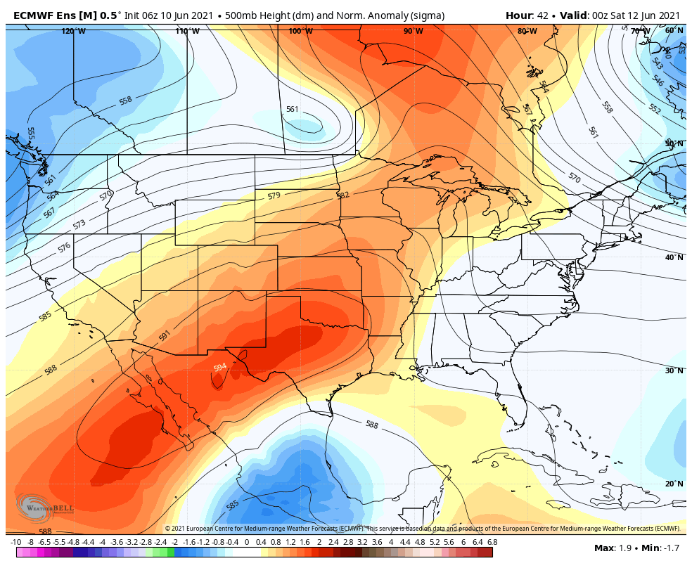 The western United States will begin to sizzle and stays mainly dry over the next week. For Maine, cooler and damper conditions will move in allowing for seasonal weather. Looking into the longer range, it appears Maine could see average to below-average temperatures and near average precipitation as more troughing is expected over our region. Stay tuned for next Thursday when an updated drought monitor comes out! Temperature outlook through mid-JuneThe plots below show the trend of the high and low temperatures for Carrabassett, Bangor, Caribou, and Portland over the next week and a half. More seasonable temperatures arrive through the rest of the week and into the weekend. This trend will continue into most of next week. 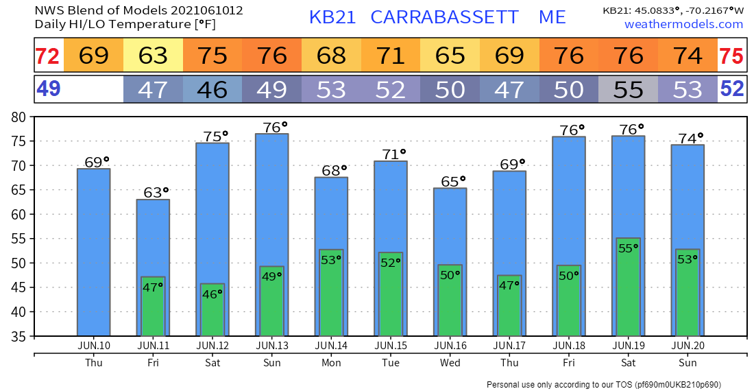 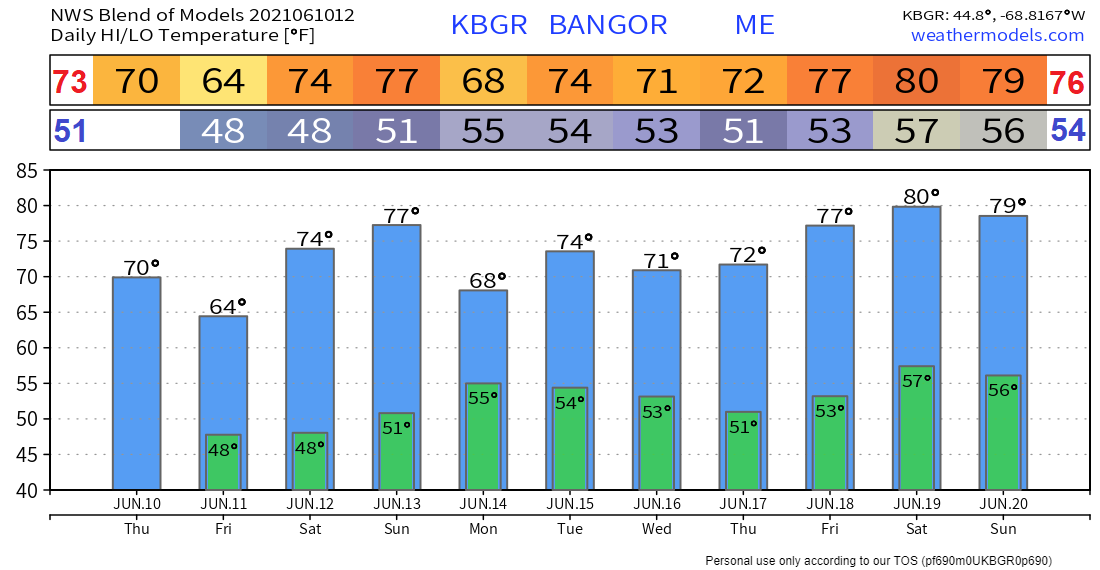 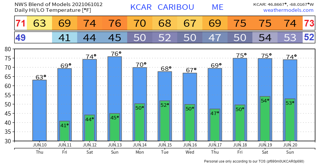 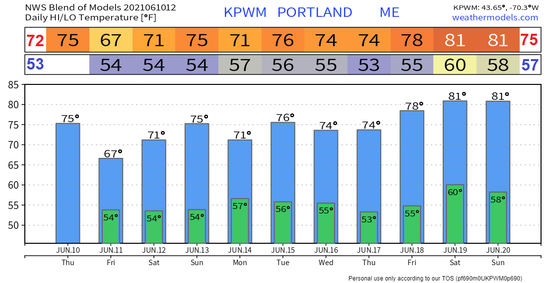 Rip Currents Safety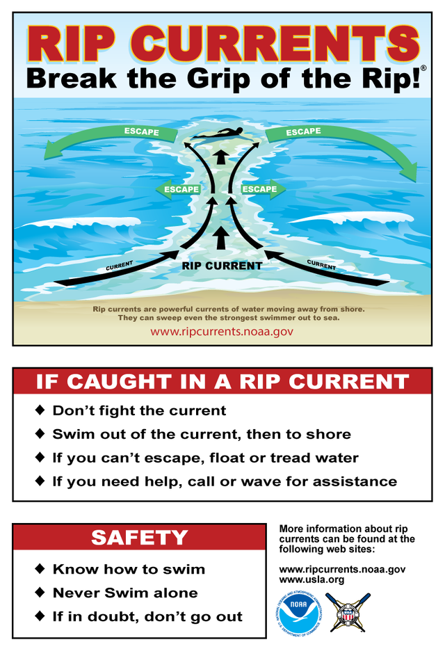 If you are swimming near a shoreline, there is always the risk of getting caught up in a rip current. Before you go to the beach: know how to swim and check the Surf Zone Forecast. When you go to the beach: if you can't swim stay out, swim at a lifeguard-protected beach, never swim alone, never swim at night, and stay at least 100 feet (30 meters) away from piers and jetties. Permanent rip currents often exist alongside these structures. If you get caught in a rip current: remain calm (you will not be pulled under the surface of the water), only swim PARALLEL to the shore to escape the current and draw attention to yourself. If you see someone in trouble: throw the rip current victim something that floats, get help from a lifeguard, or call 9-1-1 and yell instructions on how to escape the rip current (tell them which way to swim). For more information regarding rip currents, visit www.weather.gov/jetstream/rip_safety Be prepared to receive alerts and stay updated!
For more information in between posts, please follow Pine Tree Weather on Facebook and Twitter.
Thank you for supporting this community-based weather information source which operates by reader supported financial contributions. Stay updated, stay on alert, and stay safe! |

Mike Haggett
|