Chilly but fair for Sunday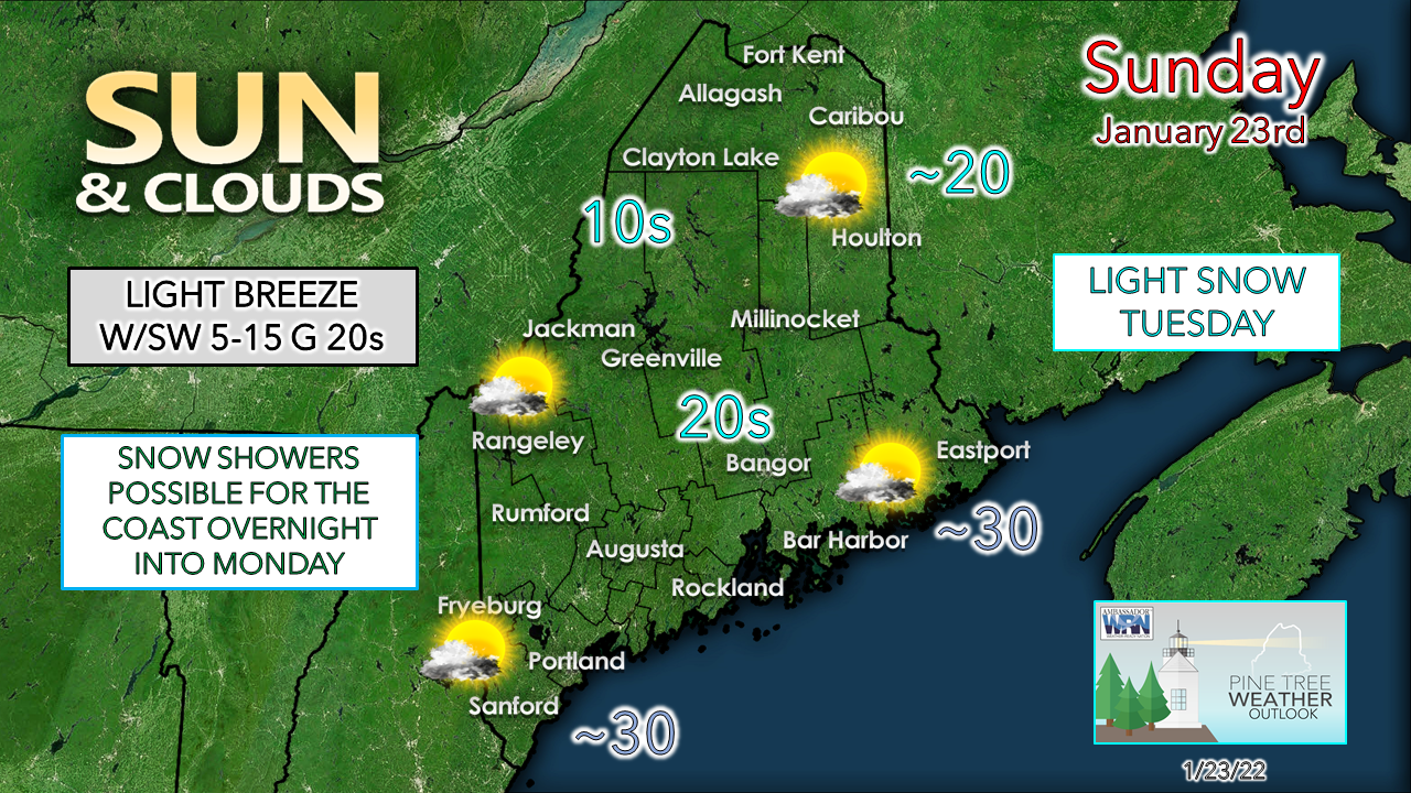 A weak cold front passes through the region for Sunday. Cloud cover builds through the day, and a light breeze picks up as well. The southwest flow helps modify temperatures to near the freezing mark for the shorelines by the afternoon. A few upslope snow showers are possible for the higher terrain and the north in the afternoon into the evening, with little to no accumulation expected. 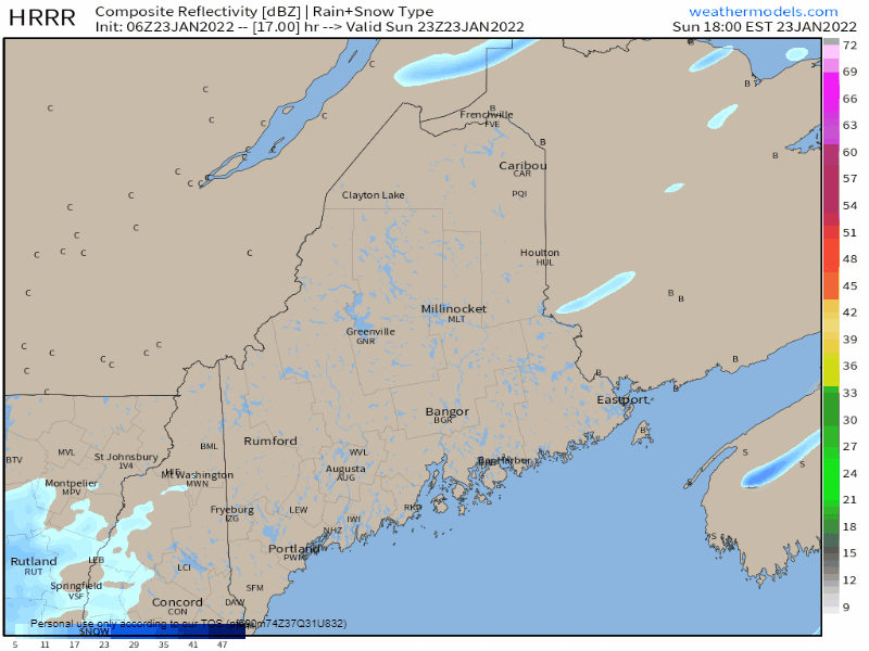 Sunday 6 PM to Monday 6 AM - Short term model idea from the HRRR shows the chance for the frontal boundary to pick up some energy from the warmth over the Gulf of Maine which could fire up snow shower activity along the shorelines overnight into Monday. It could bring a dusting to 1" of snow in spots before moving out into the Atlantic around daylight on Monday morning. This may cause some slick spots for the Monday morning commute. After the frontal passage, a weak area of high pressure passes through during the day on Monday, but not as cold as the most recent arctic blast, but temperatures continue to run well below normal. Light snow for the region Tuesday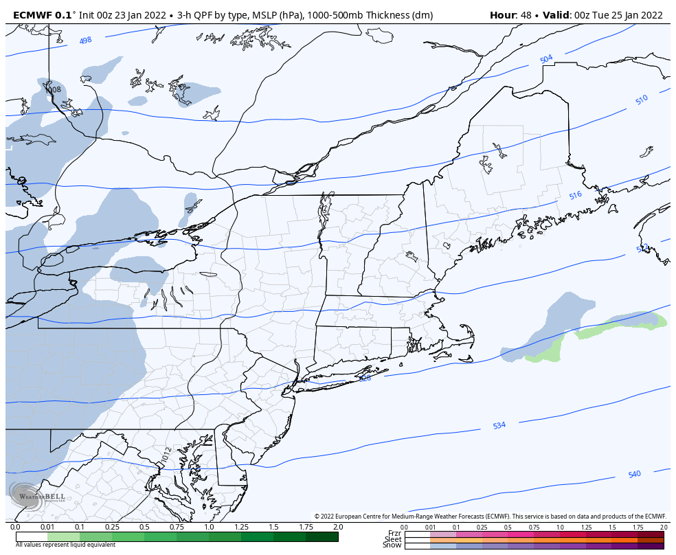 Monday 7 PM to Wednesday 1 AM - High pressure slides east Monday night. A weak clipper moves in from the Great Lakes in the overnight hours into Tuesday morning. Light, fluffy snow is likely to cover all but northern areas in time for the morning commute on Tuesday. Snow showers taper off from west to east in the afternoon, ending over northern and eastern areas Tuesday night. Shoreline regions may get a brief rain shower at the tail end of the passage. 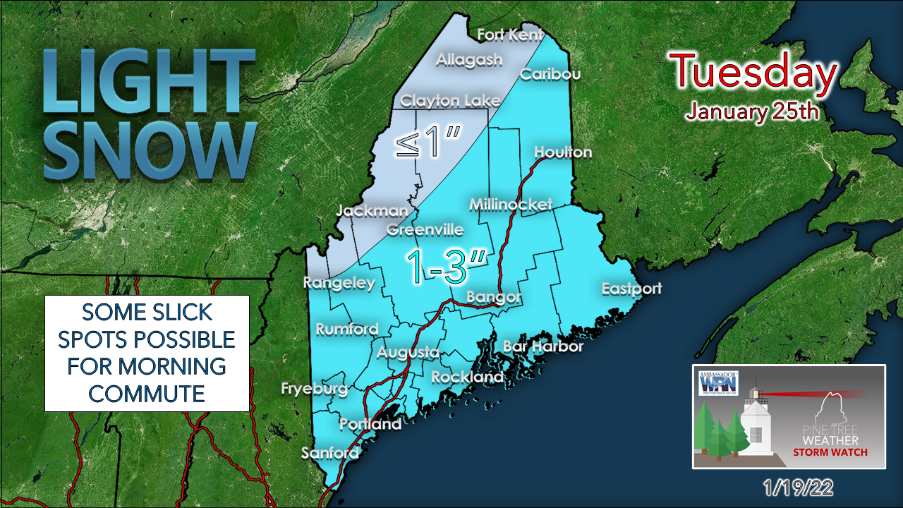 Given the "Currier and Ives" effect of the snow shower activity, I don't expect any major concerns for travel, but the secondary roads, side streets and untreated surfaces may accumulate enough snow for slick spots. Given the fluffy nature, a leaf blower is likely to be sufficient for snow removal purposes. Outlook and temperatures through the week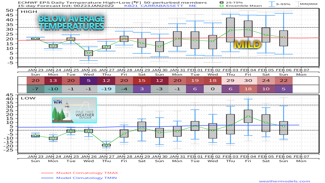 There are two questions I continue to seek answers for. The first is when will interior areas may climb above freezing? Confidence is high that it won't happen through the rest of January. Digging into ensemble ideas as well as long term outlooks, February does appear to run a bit warmer than normal. The region just cleared its coldest average temperatures for the season, and the road toward the highs of July has begun. The European ensemble mean for Carrabassett Valley shows as chance for a daily high to get near freezing around the first weekend in February. There is support in this idea as a southeast ridge is expected to form around this time and could be a dominant feature in the month ahead. The other signal I keep seeing is that February could be wetter than normal for much of the state, which leads me to my second question, what about snow? 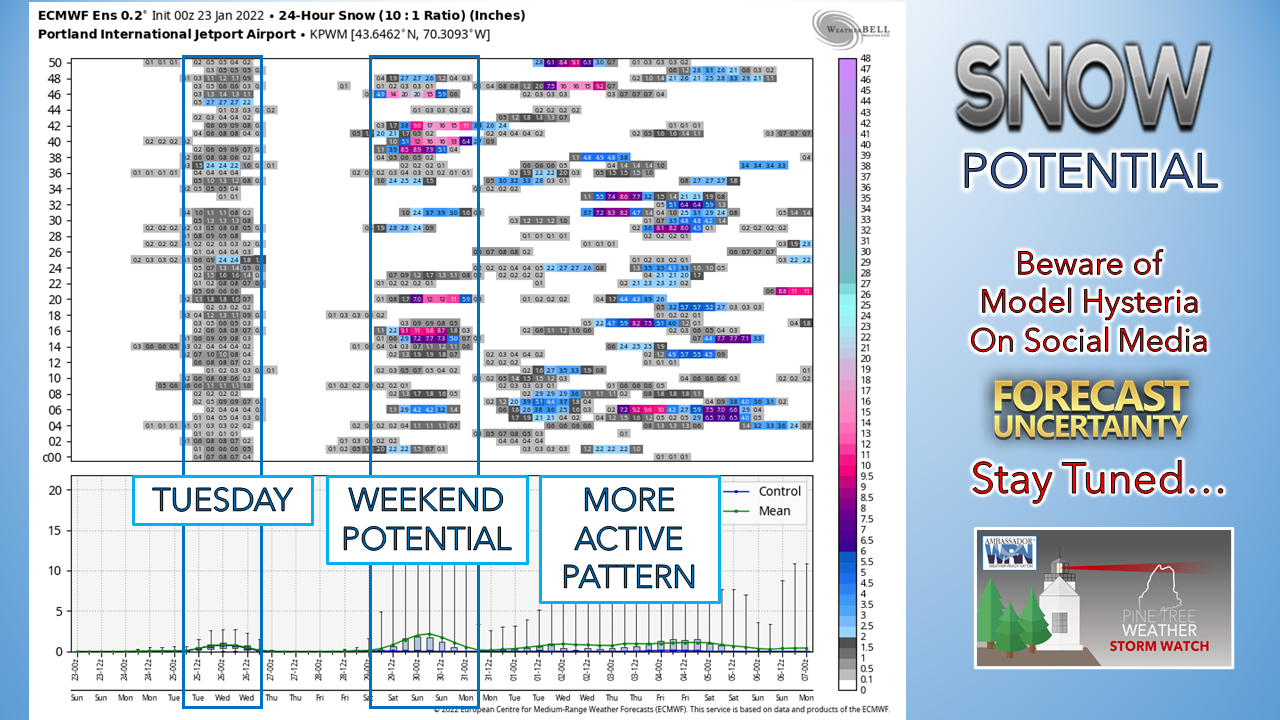 Featured location: Portland - Casting Tuesday's light snow event aside, there are signals for snow event potential next weekend. Time will tell if the ingredients come together for it to happen. Looking beyond that, the pattern does appear to pick up as we head into February. My instincts from looking at longer term guidance is that spring may be slow in coming, which has been the case over the past couple of years. Summer looks damp from what seasonal guidance I've peeked at. I take it all with a grain of salt at this point. What I keep in the back of my mind is the recent volcanic eruption near Tonga. As was seen with the Iceland activity a few years back, significant volcano activity can disrupt weather patterns. It may be early to see what impacts the recent activity may cause in the long term outlook. For the short term, stay warm. The southwest coast as a chance to get above freezing on Tuesday, but below normal cold is expected to continue overall through the rest of the month. 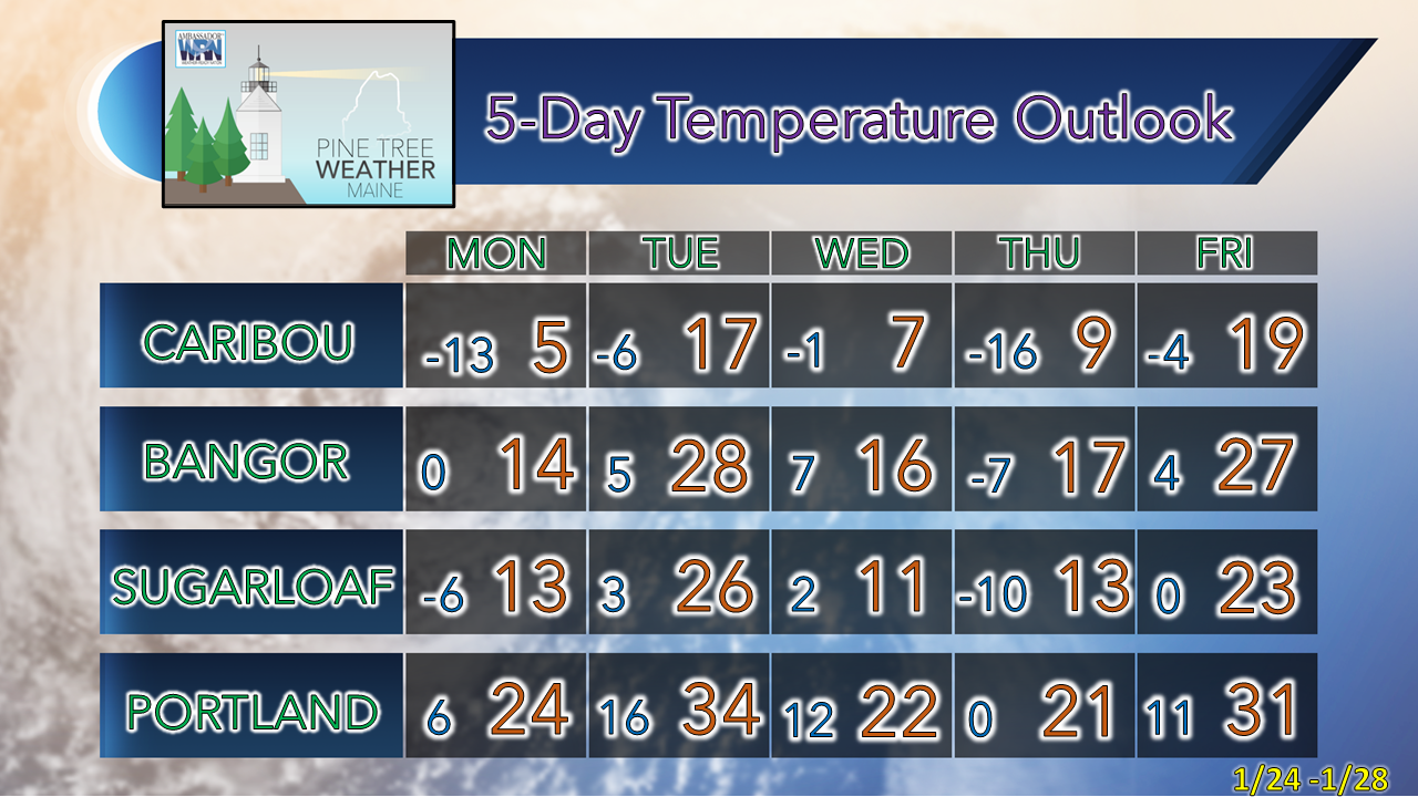  Science of Snowflakes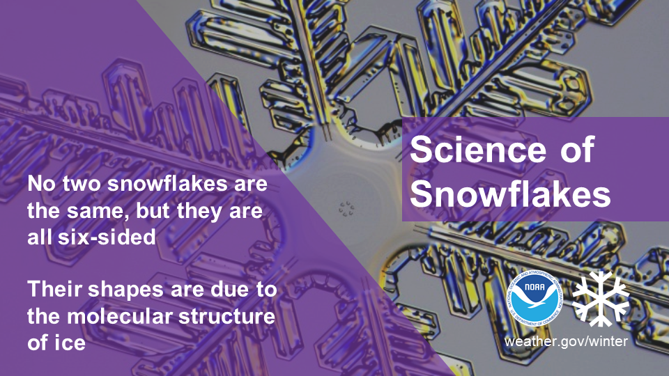 Did you know that, while no two snowflakes are exactly the same, they are all six-sided? Snowflakes’ hexagonal shapes are due to the molecular structure of ice. Learn more about the science behind snowflakes: noaa.gov/stories/how-do-snowflakes-form-science-behind-snow Be prepared to receive alerts and stay updated!
 For more information in between posts, please follow Pine Tree Weather on Facebook and Twitter. Thank you for supporting this community-based weather information source which operates by reader supported financial contributions. Thank you as always for your support! - Mike NOTE: The forecast information depicted on this platform is for general information purposes only for the public and is not designed or intended for commercial use. For those seeking pinpoint weather information for business operations should use a private sector source. For information about where to find commercial forecasters to assist your business, please message me and I will be happy to help you.
|

Mike Haggett
|