
|
First off, I would like to welcome all the new followers from Facebook and Twitter over the past few days. I hope you find what I do here to be beneficial to you. I am not trying to reinvent the weather wheel here, but I work hard to be a straight shooter, without hype and drama. Grab a cup of coffee, have a seat at the table, and I hope you enjoy the read. To follow up on my health... I am progressing in my recovery from a reaction to a ground hornet sting that occurred last Friday. I am still on the antibiotics, antihistamine, ibuprofen, and ice program, but the swelling has reduced considerably. On top of that, I tested positive for COVID for the first time Tuesday night. I am feeling no symptoms of it at all, maybe because I am doped up already, but regardless, I am good. This earned me the rest of the week off from the office, which means I can get to projects here on the website as well as tinkering with the data from my weather station, and I will likely be tweeting a fair amount. Stuck with a slow moving upper-low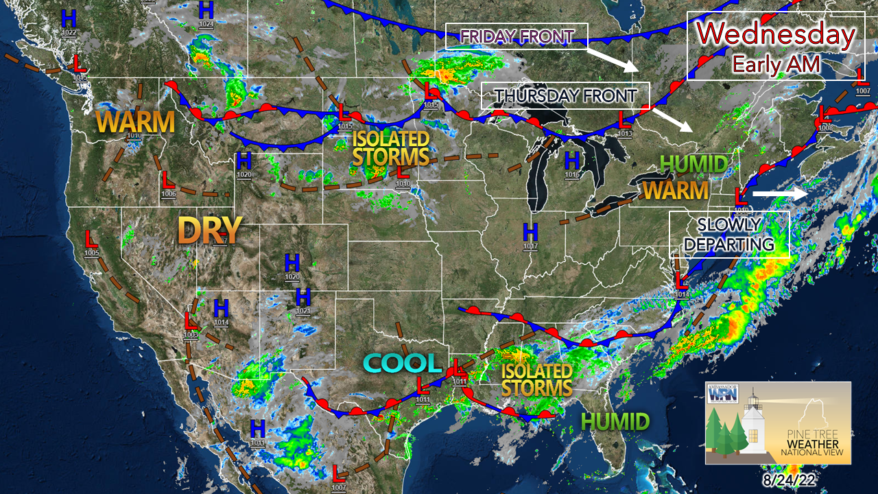 The region is sandwiched in between two frontal boundaries to start Wednesday. An upper-level low is crawling at snail pace over the region that makes turtles look fast. The center of the low disintegrates and the flow of the atmosphere picks up over the next couple of days as two frontal boundaries pass through the region. Another day, another round of showers and storms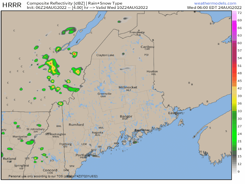 Wednesday 6 AM to Thursday Midnight - It's like a song that is on repeat on your phone or the old 45 RPM record player. The upper-low spins a parting wave through the region that brings the risk of slow-moving showers and storms which could be localized flooders in spots. Severe chances are very low, but with the elevated dew points, the atmosphere could harvest energy from it and produce an isolated strong to severe storm, with gusty wind the main threat. Potluck shower season rolls along here, and not everyone gets lucky with rain. Scattered showers are expected to continue in The County overnight into early Thursday morning. 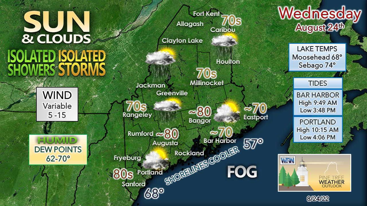 Fog could be a nemesis along the coast as maritime air holds serve along the shorelines, especially for Penobscot Bay and DownEast areas. If the sun gets out for any length of time, expect temperatures to spike up into the 80s over interior areas. Wind is expected to be light overall, but the valleys in the western mountains may see gusts in 20-25 mph range later in the afternoon as the upper-low fizzles and departs behind the showers and storms. Expect areas of fog to return Wednesday night into Thursday. Another round of showers and storms for Thursday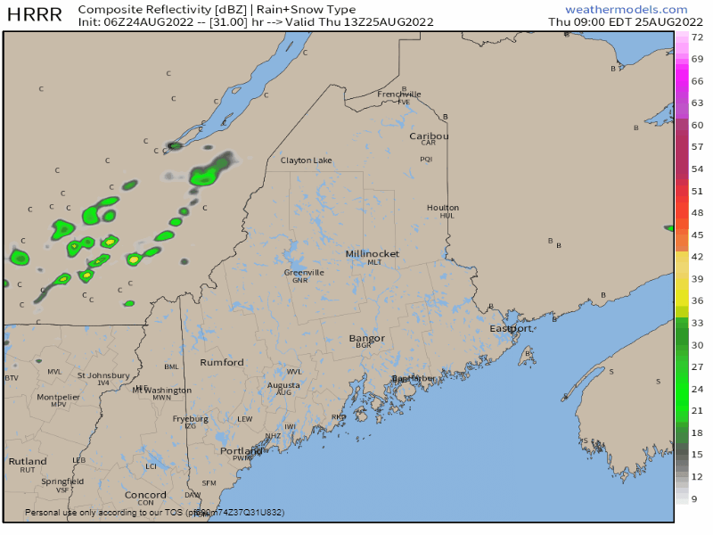 Thursday 9 AM to Friday 2 AM - The disintegrating upper-low drags a slow-moving cold front down from Quebec during the day. This brings another round of scattered showers and storms. Interior areas have the best chance to see activity, and the amount of sun dictates potential for strength of storm type. The adage "sun's out, look out" that I say so often applies here. Isolated severe storms possible for Friday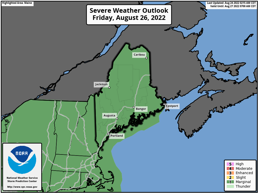 When the Storm Prediction Center puts the region on notice in the Day 3 Outlook (time sensitive link) it deserves attention. It's not very often that occurs, and when it does, it raises yellow flags of potential for a slight risk scenario or higher. This has been issued with respect to the strong cold front that is on track to pass through the region during the day. With dew points expected to rise into the upper 60s to low 70s, there will be plenty of fuel around for severe storm potential. 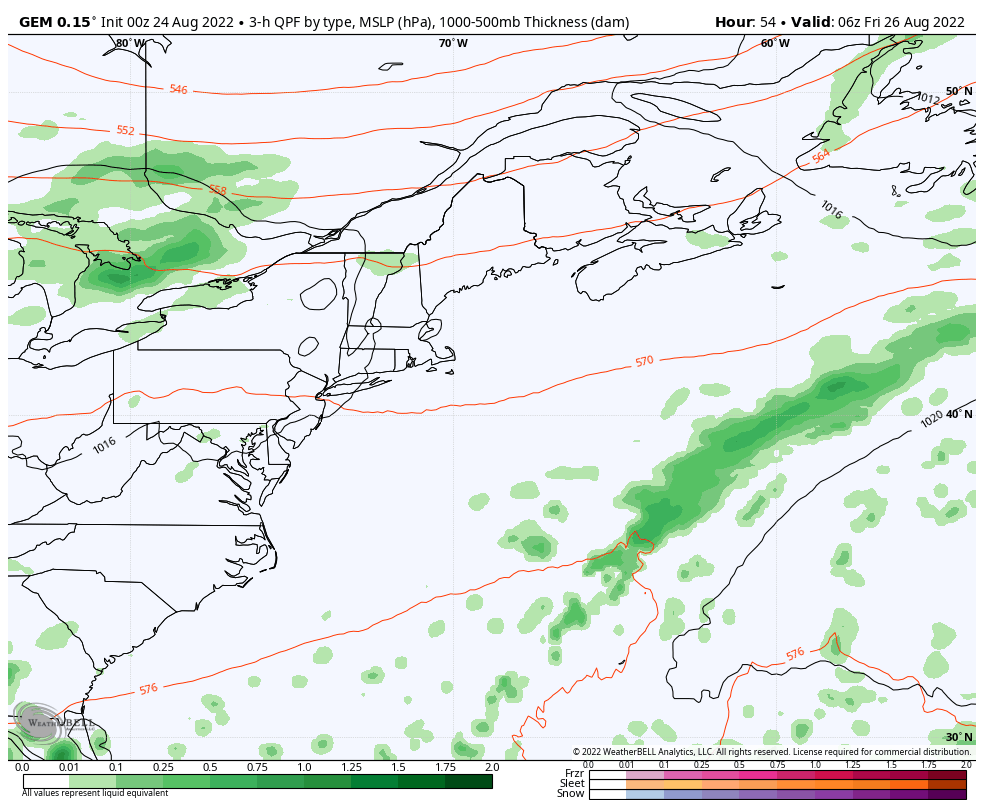 Friday 2 AM to Saturday 8 AM - Timing, potency, frequency and impacts of storms will come into better focus when the window for the short-term models arrives by Thursday morning. At this point, it's a fair bet most areas see something out of this, whether a shower or a storm. There is potential for damaging wind, flash-flood potential downpours, and hail to go along with frequent lightning. SPC hints at multicellular storms and bow structures, which if that rings true, some places could get hammered. After the front, refreshing air for the weekend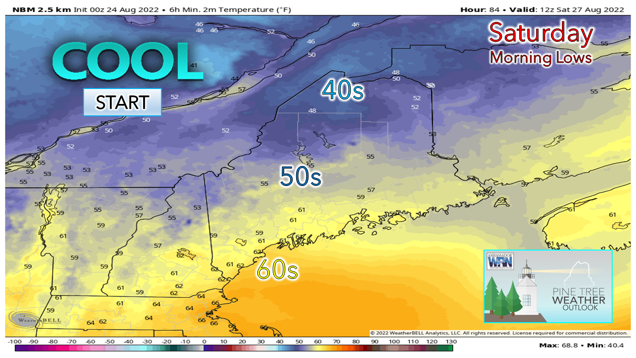 After the cold front passes through Friday, dew points drop as dry air works into the region. Temperatures are expected to be slightly below normal over the mountains for Saturday with the risk of a light shower as a northwest breeze ushers in the dry air into the area. Sunday looks good with another cool start for the north. The break from the muggy conditions is short lived as temperatures rise and humidity builds once again heading into next week. Temperature outlook through Monday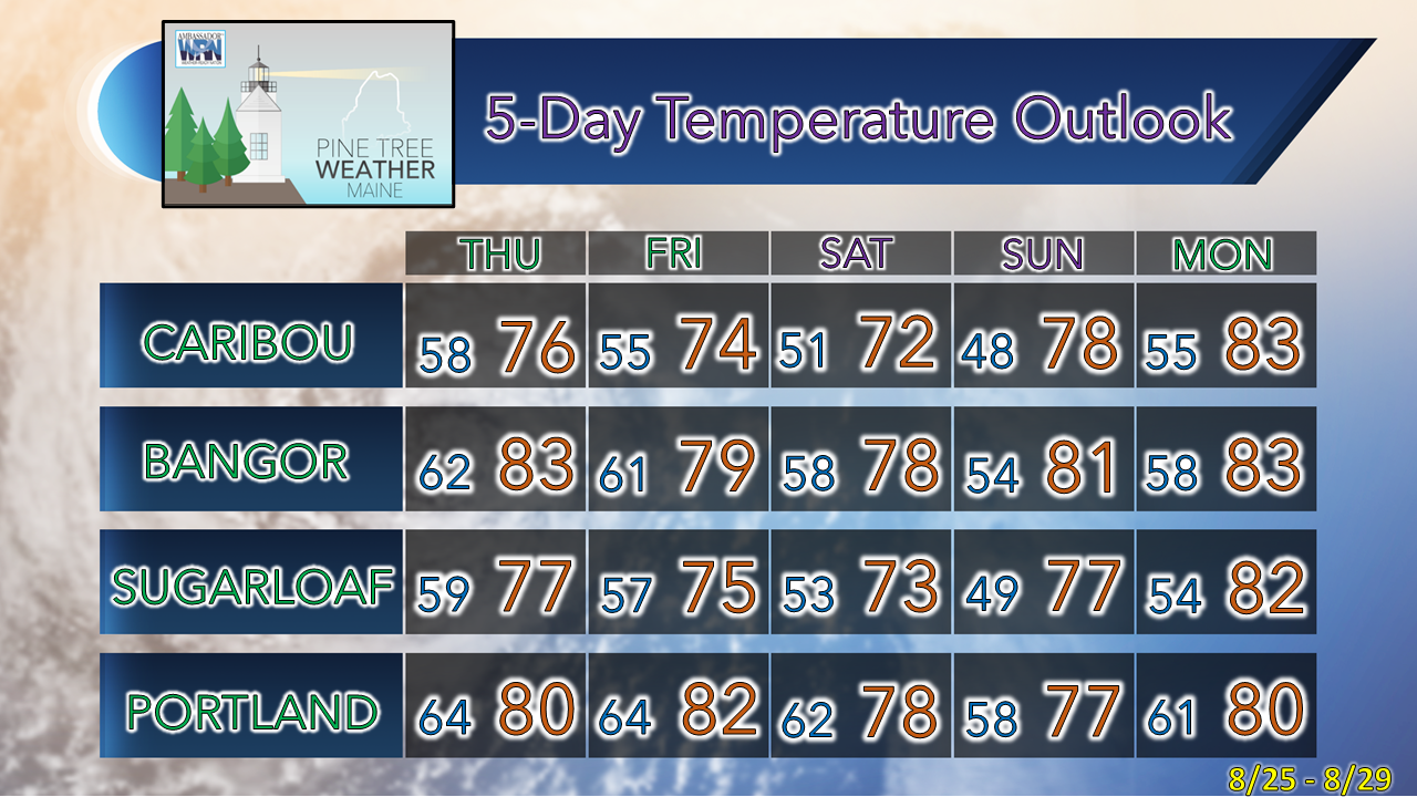 Thank you for supporting this community-based weather information source which operates by financial contributions from people like you. NEXT UPDATE: THURSDAY Stay updated, stay on alert, and stay safe! - Mike NOTE: The forecast information depicted on this platform is for general information purposes only for the public and is not designed or intended for commercial use. For those seeking pinpoint weather information for business operations, you should use a private sector source. For information about where to find commercial forecasters to assist your business, please message me and I will be happy to help you. |

Mike Haggett
|


