Pine Tree Weather
  • DISCUSSIONS
  • DONATE
  • WEATHER WALL
  • MAPS
  • RAIN OUTLOOK
  • SEVERE
  • MARINE
  • CPC OUTLOOK
  • Kennebunk
  • MY BIO
  • PTW IN MEDIA
  • OBSERVING WEATHER
  • INTERNSHIPS
  • INTERN ALUMNI
  • DISCUSSIONS
  • DONATE
  • WEATHER WALL
  • MAPS
  • RAIN OUTLOOK
  • SEVERE
  • MARINE
  • CPC OUTLOOK
  • Kennebunk
  • MY BIO
  • PTW IN MEDIA
  • OBSERVING WEATHER
  • INTERNSHIPS
  • INTERN ALUMNI

Chilly temperatures for the next few days and into 2021, continued observation on January 1st/2nd system

12/28/2020

Comments

 
Picture

Leftover precipitation from departing cold front​

Picture
The GIF above runs from 7 PM Monday to 7 AM Tuesday and displays reflectivity by precipitation type. As a cold front departs, the atmosphere may squeeze out some last minute light snow/flurries in the northwestern areas of Maine, and light rain moving eastward in the eastern portions of the state. The rest of the week leading up to the New Year's Day system shows minimal to no precipitation, but mostly cloudy to overcast skies for most areas.

Cold temperatures from northwest winds bring Canadian cold air

Picture
The GIF above runs from 7 PM Monday to 7 AM Wednesday and shows temperature in degrees Fahrenheit. After the departure of the cold front, northwesterly winds bring cold temperatures from Canada and reside in the state for about a day and a half, since there isn't an oncoming  nearby disturbance to change wind direction or air flow in general. The next system that is expected to impact Maine on New Year's Day will bring warmer temperatures in addition to mixed-type precipitation.

Upcoming January 1st/2nd system

Picture
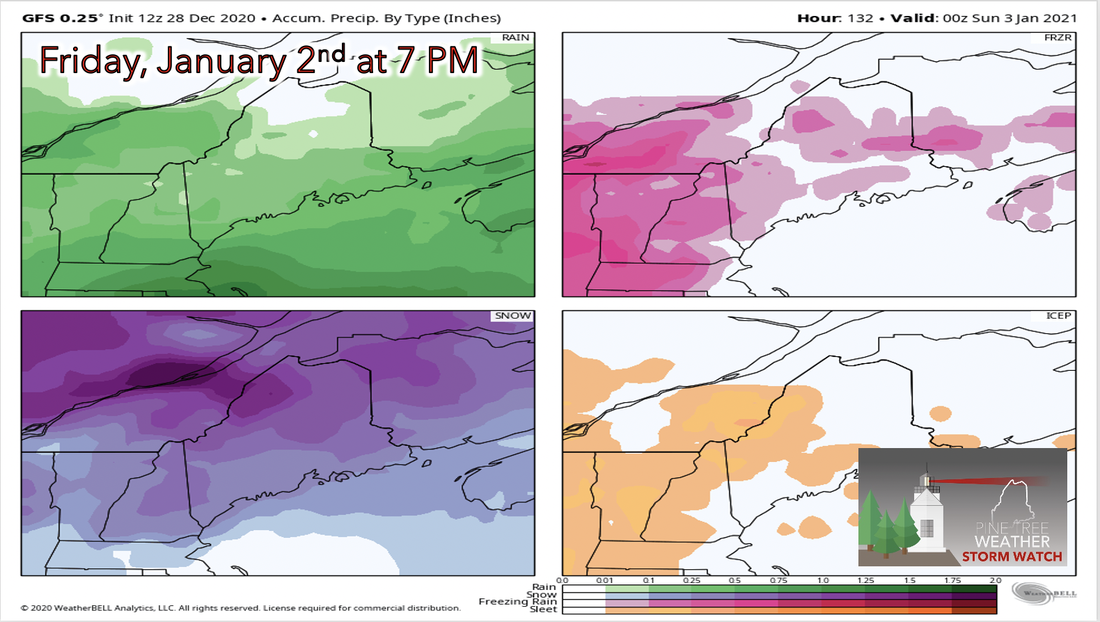
The image above displays rain (upper left), freezing rain (upper right), and snow (lower left) total in inches. After two days, some things have changed in the long-range forecast for this upcoming system. First, precipitation is more widespread and not as concentrated. This gives an indication that this storm won't be as strong as previously thought. Second, the temperature gradient that balances around 32 degrees Fahrenheit is not as thin as it previously was either. More widespread snow and rain to the north and south respectively is expected, and less of a chance for freezing rain in the midsections of the state.

January 1st/2nd system temperatures

Picture
The GIF above runs from 7 AM Saturday, January 2nd to 7 PM Sunday, January 13th and displays temperature in degrees Fahrenheit. The beginning of the loop shows the potential temperatures during the time that the system is currently forecasted to move into the state. As this system moves through, the warm sector from the warm front of the system is expected to cross over the state, giving less confidence on what type of precipitation will occur and where it will occur. This new data suggests a pretty fair split of snow and rain on the north and south side of the state respectively. After this system moves through, colder temperatures are expected to move through, much like how these upcoming temperatures are decreasing from northwesterly winds bringing down cold Canadian air.

​Be prepared to receive alerts and stay updated!

Picture
BE PREPARED WITH A NOAA Weather Radio.

​For $20-$40, it could provide important information to you when you need it. The weather bands are standard on most public safety scanners, and newer scanner models. Weather radios can be programmed for auto alert.  Click here for more information.
► ► For the latest official forecasts, bulletins and advisories, please check in with the National Weather Service in Gray for western and southern areas, or Caribou for northern and eastern parts of Maine
Picture
For more information, please follow Pine Tree Weather on Facebook and Twitter. 

** FUNDING NEEDED FOR 2021 **
​Thank you for supporting this community based weather information source that is funded by your financial contributions. 


Stay updated, stay on alert, and stay safe!
Have a great rest of your day!

​- Kaitlyn
Comments
    Picture

    Mike Haggett
    Kennebunk, ME

    Weather-Ready Nation
    Ambassador

    Certified Weather
    Forecaster
    Penn State '21

    American Meteorological Society

    National Weather Association
    ​
    ​SKYWARN-CWOP

    Matthew 19:26


    DONATE

    Picture
    Picture
    Picture
    Picture
    Picture

    Picture

    Picture

    Picture

    Picture

    Picture

    Picture

    Picture

    Picture

    Picture

    Picture

    Picture

    Picture


    Archives

    April 2025
    March 2025
    February 2025
    January 2025
    December 2024
    November 2024
    October 2024
    September 2024
    August 2024
    July 2024
    June 2024
    May 2024
    April 2024
    March 2024
    February 2024
    January 2024
    December 2023
    November 2023
    October 2023
    September 2023
    August 2023
    July 2023
    June 2023
    May 2023
    April 2023
    March 2023
    February 2023
    January 2023
    December 2022
    November 2022
    October 2022
    September 2022
    August 2022
    July 2022
    June 2022
    May 2022
    April 2022
    March 2022
    February 2022
    January 2022
    December 2021
    November 2021
    October 2021
    September 2021
    August 2021
    July 2021
    June 2021
    May 2021
    April 2021
    March 2021
    February 2021
    January 2021
    December 2020
    November 2020
    October 2020
    September 2020
    August 2020
    July 2020
    June 2020
    May 2020
    April 2020
    March 2020
    February 2020
    January 2020
    December 2019
    November 2019
    October 2019
    September 2019
    August 2019
    July 2019
    June 2019
    May 2019
    April 2019
    March 2019
    February 2019
    January 2019
    December 2018
    November 2018
    October 2018
    September 2018
    August 2018
    July 2018
    June 2018
    May 2018
    April 2018
    March 2018
    February 2018
    January 2018
    December 2017
    November 2017
    October 2017

Proudly powered by Weebly