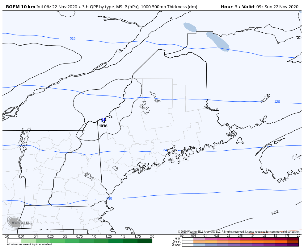
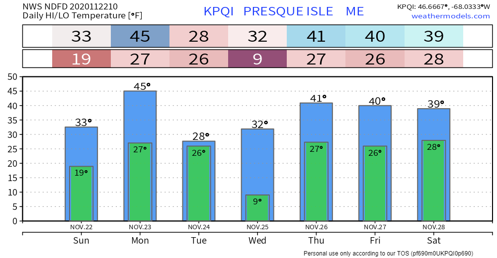
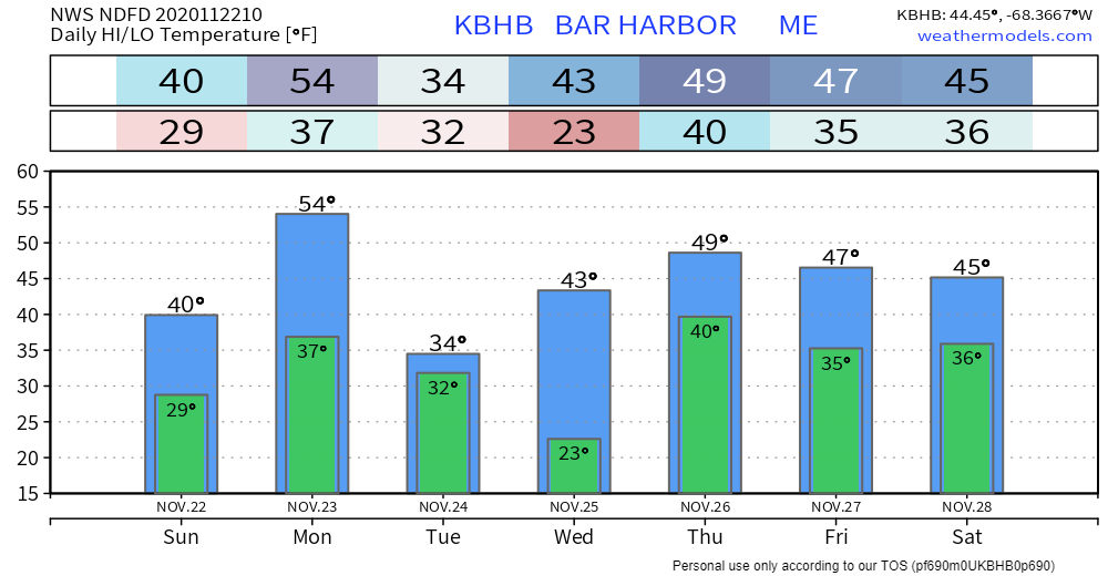
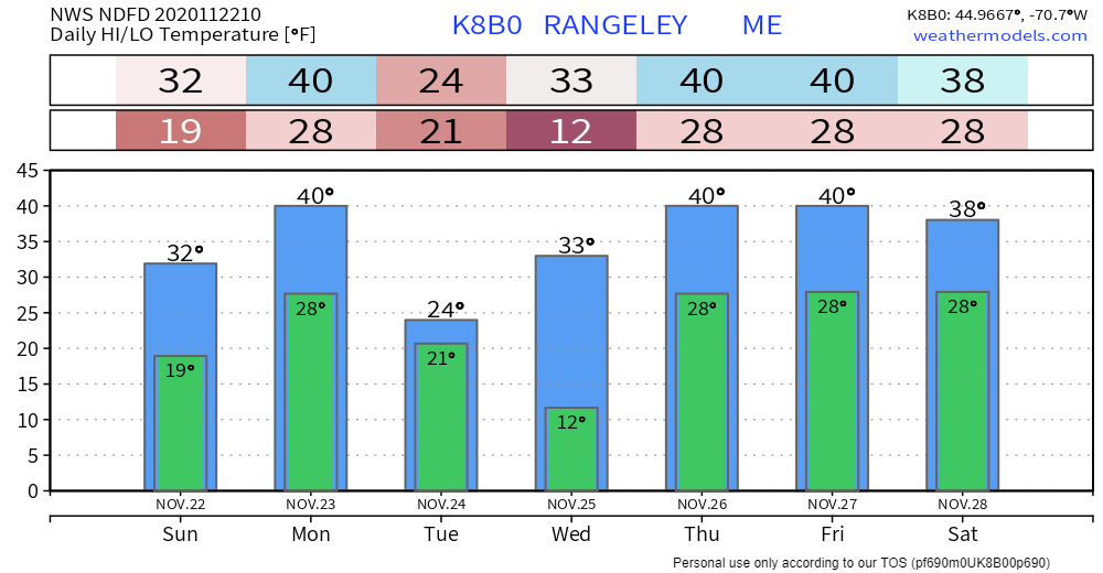
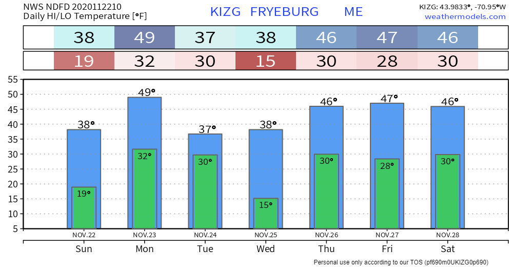
Pine Tree Weather
  • DISCUSSIONS
  • MAPS
  • BRIEFINGS
  • SATRAD
  • MARINE
  • RAIN OUTLOOK
  • SNOW / ICE OUTLOOK
  • CPC OUTLOOK
  • Kennebunk
  • Weather Geekdom
  • Who We Are
  • DONATE
  • My Photography
  • DISCUSSIONS
  • MAPS
  • BRIEFINGS
  • SATRAD
  • MARINE
  • RAIN OUTLOOK
  • SNOW / ICE OUTLOOK
  • CPC OUTLOOK
  • Kennebunk
  • Weather Geekdom
  • Who We Are
  • DONATE
  • My Photography

Clouds increase Sunday ahead of a stormy Monday

11/22/2020

Comments


The calm before the storm

Picture
Sun will be the dominant feature in the sky to start off, but clouds will take over as the day progresses. Eastern areas have the best chance to stay mainly sunny for the day. It will be on the cool side, but with little wind until Sunday evening. With a warm front working in, temperatures will rise into tonight.

It will be a good day to get out and enjoy the fresh air. 

Precipitation and wind arrives Sunday evening
​and continues into Monday

Picture
High pressure quickly moves to the east Sunday afternoon. A warm front works in from the southwest and brings moisture along with it. Interior areas start off as snow, changing to sleet and/or freezing rain, then to all rain for most areas Monday morning. Precipitation tapers from west to east Monday evening. Snow showers will persist in the mountains into Tuesday.
Picture
No changes in the precipitation outlook posted here on Saturday. The idea of ½-1" of liquid equivalent remains intact. Area of the MidCoast & DownEast may exceed 1" of rainfall in spots. Any snow south of the mountains is likely to melt by morning. The ski hills may pick up an inch or two on the backside from upslope snow showers Monday night into Tuesday. 
Picture
A Wind Advisory is posted for Coastal Hancock and Coastal Washington counties, where wind gusts may reach 50 mph Monday. The stronger gusts exit western areas by around noon, eastern areas by mid-afternoon.

After the cold front passes through, the wind direction shifts to the northwest. Expect a breezy, cold day on Tuesday, with wind chill indices around 0° for the western mountains, single digits to low teens in the north, and teens to around 20° for the coastal plain.

Picture

Thanksgiving could be messy to start off

Picture
High pressure moves in by early Wednesday and passes east by Wednesday evening. Another similar set up for snow in the north and rain for the south is possible for Thanksgiving. Once that system passes, a closed upper low pinwheels through the region. This may bring a mixed bag for the north and showers to the south on Friday. 

Temperature outlook through Saturday

After temperatures fall below normal midweek, the mercury climbs above normal as we head into Thanksgiving and next weekend.

The normal high/low for this time of year is 36°/23° for Caribou and 46°/30° for Portland. 
Picture
Picture
Picture
Picture

Science of Frost Formation

​Frost can be annoying to scrape off your car, but did you ever think about how it got there? Watch this video for a little frost science.

​Be prepared to receive alerts and stay updated!

Picture
​BE PREPARED WITH A NOAA Weather Radio.

​For $20-$40, it could provide important information to you when you need it. The weather bands are standard on most public safety scanners, and newer scanner models. Weather radios can be programmed for auto alert.  Click here for more information.

​​► ► For the latest official forecasts, bulletins and advisories, please check in with the National Weather Service in Gray for western and southern areas, or Caribou for northern and eastern parts of Maine
Picture

For more information, please follow Pine Tree Weather on Facebook and Twitter. 

** FUNDING NEEDED FOR 2021 **
​Thank you for supporting this community based weather information source that is funded by your financial contributions. 


Stay updated, stay on alert, and stay safe!

​- Mike
Comments
    Picture

    Mike Haggett
    Kennebunk, ME

    Penn State
    Weather Forecast Certification '21.
    AMS / NWA
    Weather-Ready Nation 
    ​SKYWARN-CWOP

    Picture

    Alex Hatfield
    Wakefield,MA


    Penn State
    Meteorology and Atmospheric Science ‘21
    PSUBAMS
    Campus Weather Service
    PSU Storm Chase Team
    PSU College of Earth &  Mineral Sciences Ambassador

    Picture

    Kaitlyn Lardeo
    ​Syracuse, NY

    SUNY Oswego
    Atmospheric Science
    Lake Effect Storm Prediction and Research Center
    Northeastern Storm Conference Contributor

    DONATE
    Picture

    Archives

    January 2021
    December 2020
    November 2020
    October 2020
    September 2020
    August 2020
    July 2020
    June 2020
    May 2020
    April 2020
    March 2020
    February 2020
    January 2020
    December 2019
    November 2019
    October 2019
    September 2019
    August 2019
    July 2019
    June 2019
    May 2019
    April 2019
    March 2019
    February 2019
    January 2019
    December 2018
    November 2018
    October 2018
    September 2018
    August 2018
    July 2018
    June 2018
    May 2018
    April 2018
    March 2018
    February 2018
    January 2018
    December 2017
    November 2017
    October 2017

    Categories

    All
    Maine Weather
    Pine Tree Weather

    RSS Feed

Proudly powered by Weebly