
|
Before I get into the forecast, I want to say thank you to those who have made contributions to keep Pine Tree Weather going into 2023. Currently I am at about 20% funded for the year. I know times are tough with inflation and the cost to keep warm. The truth be known I have funneled thousands of dollars of my own into this between education, forecasting data, a laptop, graphics and everything else I need to deliver a top rate product that rivals anything you'll find anywhere else. The bottom line is that I am done paying out of the pocket for this. Whether or not this entity continues is entirely up to people like you who consume it. I love what I do here, but it comes to a point where it isn't worth my effort when I am not supported by those who follow it. If by chance I do not achieve my goal for what I need, all VENMO and check donations will be refunded or returned, Patreon will be cancelled, and this website will disappear. It is totally up to you. If you own a business and would like to cross promote and/or sponsor, send me a message so we can arrange to have a conversation to see what we can come up with and where we can work together to support one another. A messy but manageable storm for the interior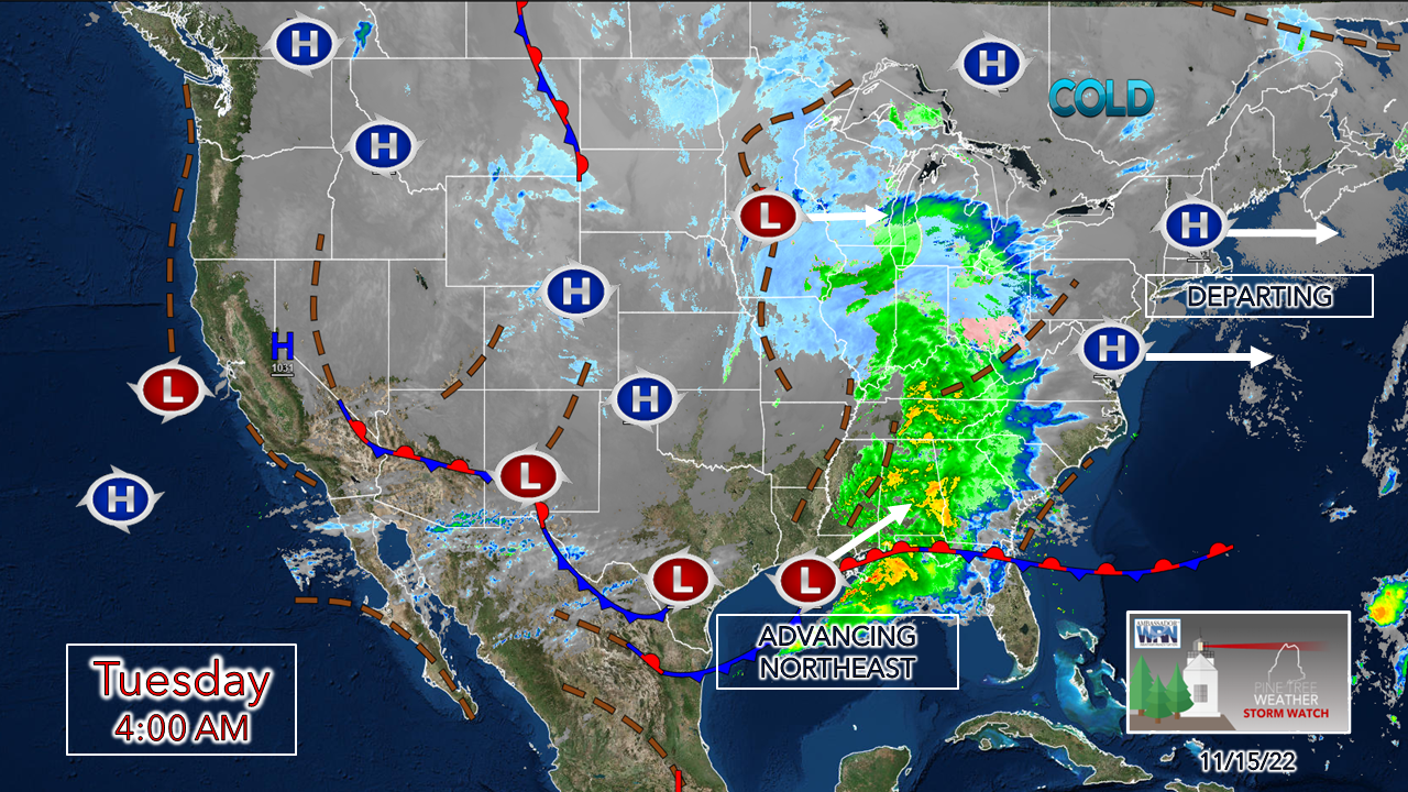 As of early Tuesday, a winter storm watch continues for northern Maine and winter weather advisories have been issued for the western mountains, foothills and Lakes Region north of Sebago. High pressure moves offshore Tuesday, Low pressure over the central Gulf of Mexico moves northeast and brings the kitchen sink of precipitation variety to Maine Wednesday. A calm Tuesday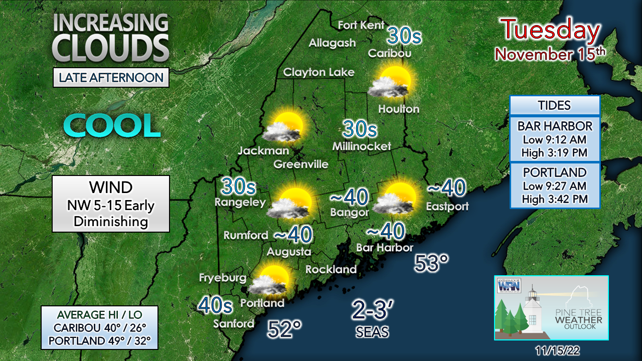 Any early morning breeze settles down as the day progresses. It's the proverbial "calm before the storm", so to speak. High clouds filter the skies, mid-level clouds build in over southwest areas later in the day. Temperatures are expected to run 5-10° below normal on the high and low end. Coastal hugger storm works through Wednesday Tuesday 7 PM to Thursday 1 PM - The track is homing in closer to the coast with intensification occurring to the northeast as it heads into the Canadian Maritimes. The closer to the coast comes more of a concern for a wintry mix of freezing rain, sleet and snow that could reach as far inland as the western mountains. The southwest coast may see some early morning flakes, but rain appears to be the main precipitation type. I haven't been impressed with this storm and here are a couple of examples as to why: 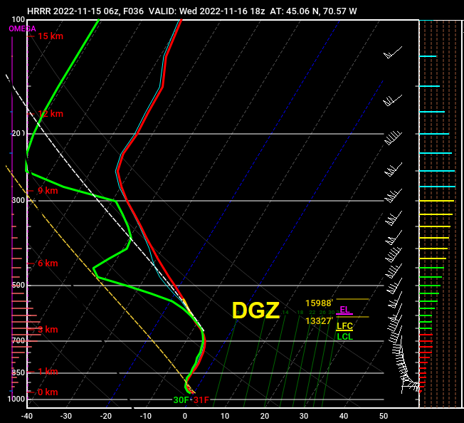 I mentioned the dendritic (snow) growth zone being short in Monday's update. Here's what the HRRR model is forecasting for Sugarloaf at 2 PM Wednesday. A very narrow area of about 2,600 feet for snow to develop and grow. For any snow of accumulation value, which needs to range 3,500 feet or more, and lower in altitude. You can also see where the warm nose plays a factor, and why this snow will be wet for that area.  Wednesday 1 AM to Thursday 1 AM - Then there is the vertical wind shear hammering snowflakes as they fall. While the surface wind is marginal, the wind will be screaming aloft as the storm intensifies. This is a dendritic disaster in the making. Unhealthy snowflakes mean less than desirable outcomes for accumulation.  Tuesday 11 PM to Wednesday Noon - With cold high pressure to the north filtering cool, dry air down from Quebec, it may take a while for precipitation to fall and accumulate heading into the Wednesday morning commute. I do expect some issues for the coastal interior and the foothills with some snow that could create some slick spots, especially on the roads less travelled. By mid to late morning, snow changes over to sleet and freezing rain over the coastal interior on up into the foothills.  Wednesday Noon to Thursday 1 AM - A dry slot works into the storm which may set up pockets of freezing drizzle over the interior as cold air damming at the surface. Areas of freezing rain and sleet work into the western mountains and into southeast Aroostook. Precipitation ends from southwest to northeast Wednesday afternoon into the night, ending over northern areas in the wee hours of Thursday. Some snow showers are possible for the mountains as the wind picks up from the northwest as the storm departs. 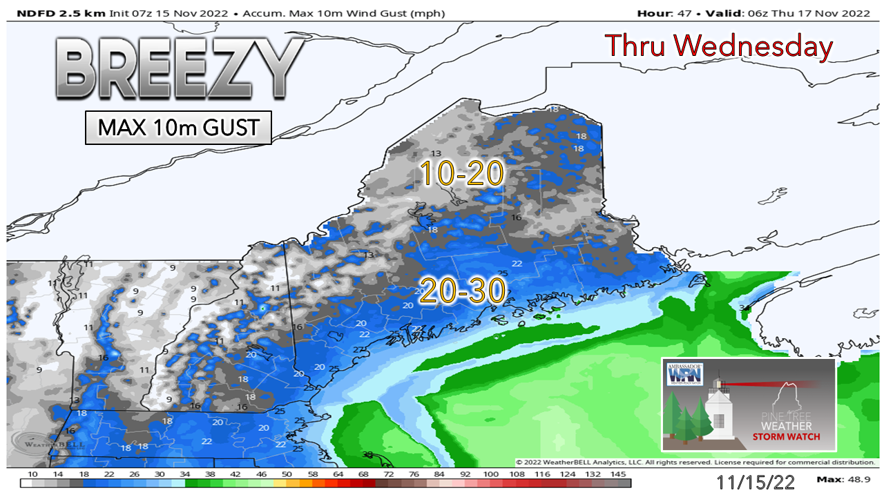 Speaking of the wind, we've had far worse NorEasters in that regard. I don't expect any real concerns from it. Areas where snow sticks to trees and power lines may see some isolated outages, but it does not appear to be anything significant. 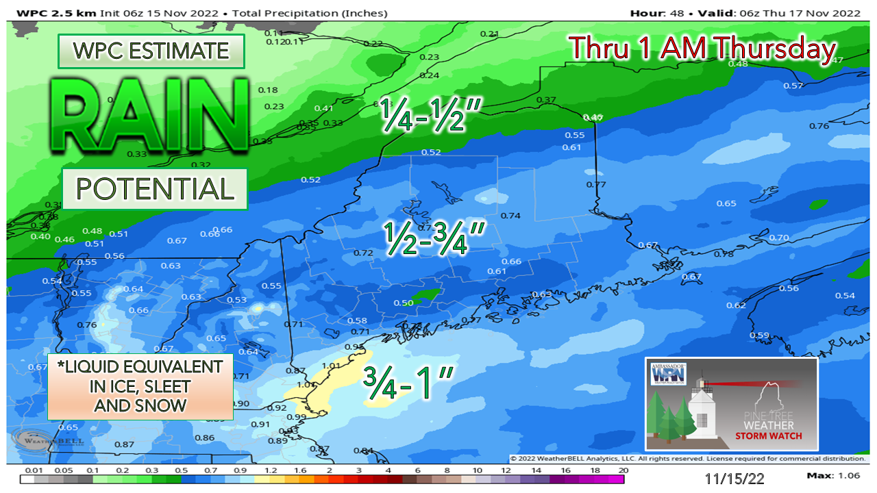 The forecast for the amount of water associated with the system has been pretty consistent. Coastal areas will get a decent amount of rain from it. 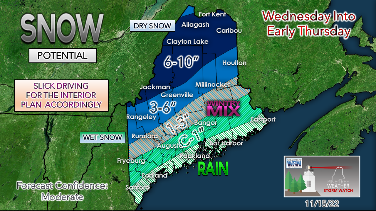 The further north, the drier the snow. The wintry mix and rain will cut down snowfall amounts for the western mountains on south and east. A good ol' early season slop fest. For the ski areas, it's a start. Plenty of cold around for the snow guns to lay a base and get the lifts going for the next several days.  Outlook through SundayAfter this storm passes, there is a chance for rain / snow for Sunday, but nothing definitive yet. Temperatures continue to run below normal throughout the period. 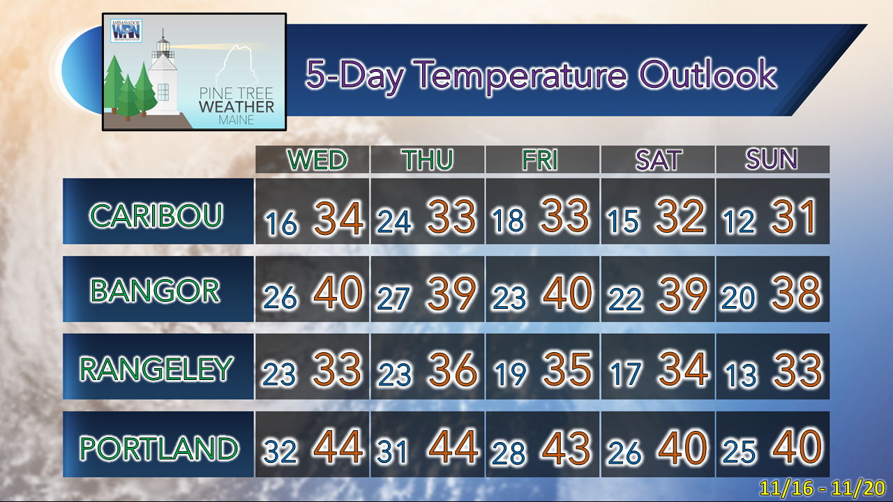 The future of Pine Tree Weather is your call...  Thank you as always for your support! Stay updated, stay on alert, and stay safe! - Mike NOTE: The forecast information depicted on this platform is for general information purposes only for the public and is not designed or intended for commercial use. For those seeking pinpoint weather information for business operations, you should use a private sector source. For information about where to find commercial forecasters to assist your business, please message me and I will be happy to help you |

Mike Haggett
|


