Pine Tree Weather
  • DISCUSSIONS
  • DONATE
  • MAPS
  • NWS BRIEFINGS
  • SATRAD
  • MARINE
  • SNOW / ICE OUTLOOK
  • RAIN OUTLOOK
  • CPC OUTLOOK
  • Kennebunk
  • OBSERVING WEATHER
  • Who We Are
  • My Photography
  • DISCUSSIONS
  • DONATE
  • MAPS
  • NWS BRIEFINGS
  • SATRAD
  • MARINE
  • SNOW / ICE OUTLOOK
  • RAIN OUTLOOK
  • CPC OUTLOOK
  • Kennebunk
  • OBSERVING WEATHER
  • Who We Are
  • My Photography

Cold front to bring a few showers and storms Tuesday

8/2/2022

Comments


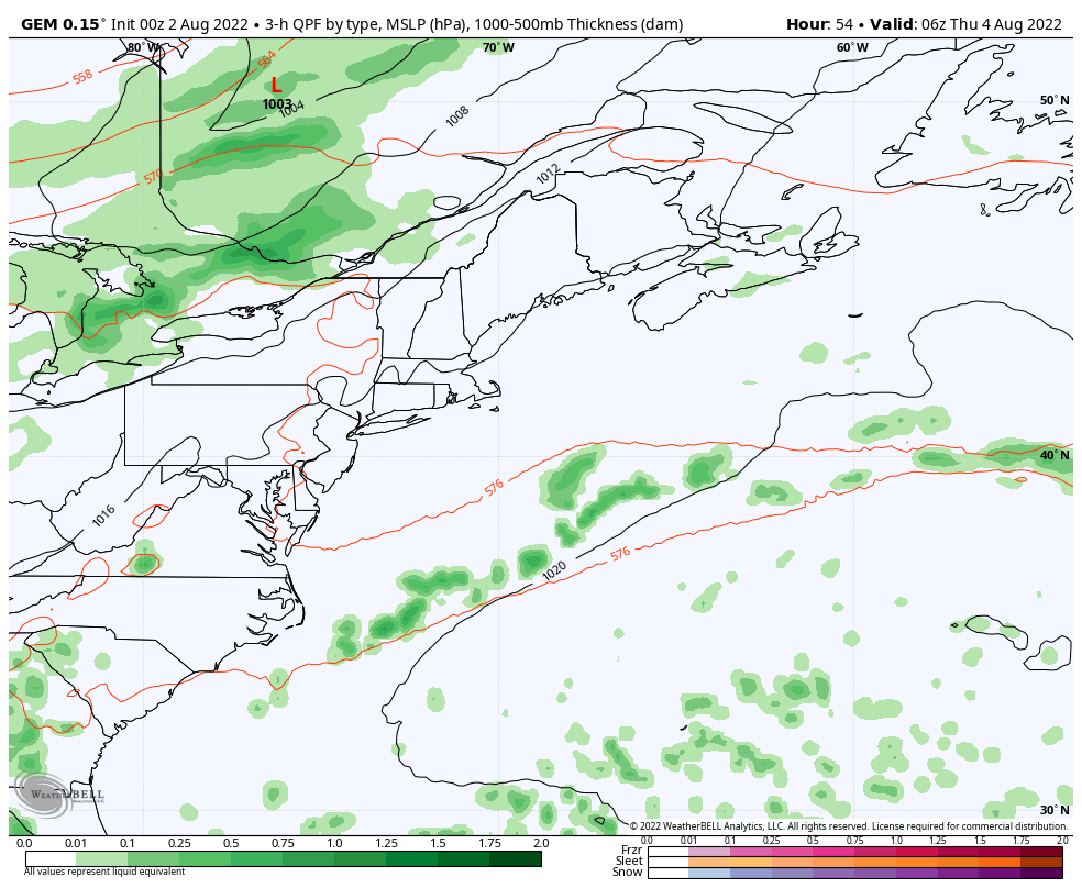
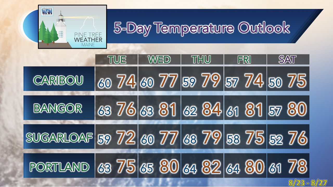
Potluck shower and storm season continues

Picture
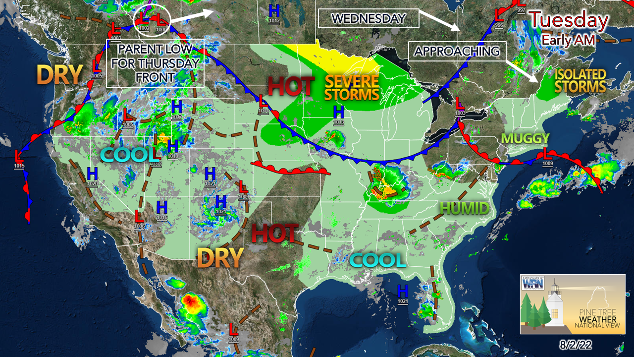
The drought is on the minds of many who dwell south of The County as the lack of widespread rain is showing its impact in several ways. I've been guarded talking about potential rainfall as the long-term ideas look hopeful but end up coming way short on results when the time arrives. Rather than look like a complete fool by raising false hopes where many rely on groundwater resources, as I did for 17 years in my time in Poland, I am not going there. Conservation is key right now. The good news is we're about to cross the halfway point of summer. I see signals of a pattern shift going into the middle part of the month back to a more troughy one which cools things off and increases rain chances. That said, a drought busting rain event isn't easily seen right now. Hurricane season has been very quiet compared to recent years to this point, and there are signals where tropical events could increase. It's going to take something along those lines to bring much needed rain to the area. We just need to hang in there in the meantime. 

Isolated strong to severe storm possible Tuesday

Picture
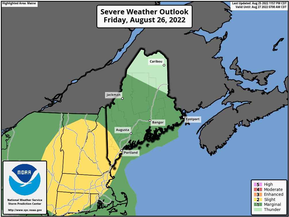
Storm Prediction Center has indicated marginal risk for severe storms across the north and much of the central part of the state for Tuesday, as of their 1:30 AM ET update. The main concern here is for isolated strong to severe storms which could produce damaging wind, some hail and localized flash flooding from tropical downpours. 
Picture
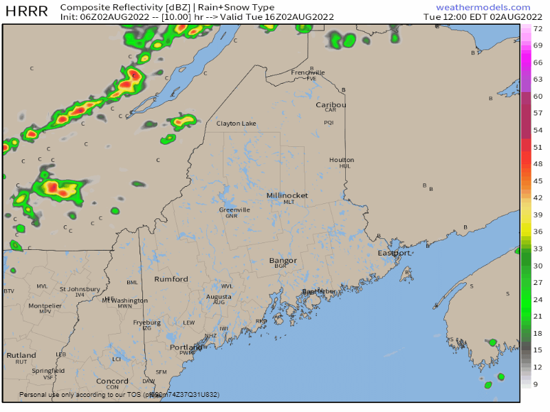
Tuesday Noon to Wednesday Midnight - Short term guidance has been pretty consistent with the ideas of how this may play out since the time period reached its window. The best chance for activity is for the western mountains over to the Capitol District, north and east. Much of the coastal plain does not appear to get in on the action, other than an isolated shower, given the timing of the frontal passage and the marine layer influence. 
Picture
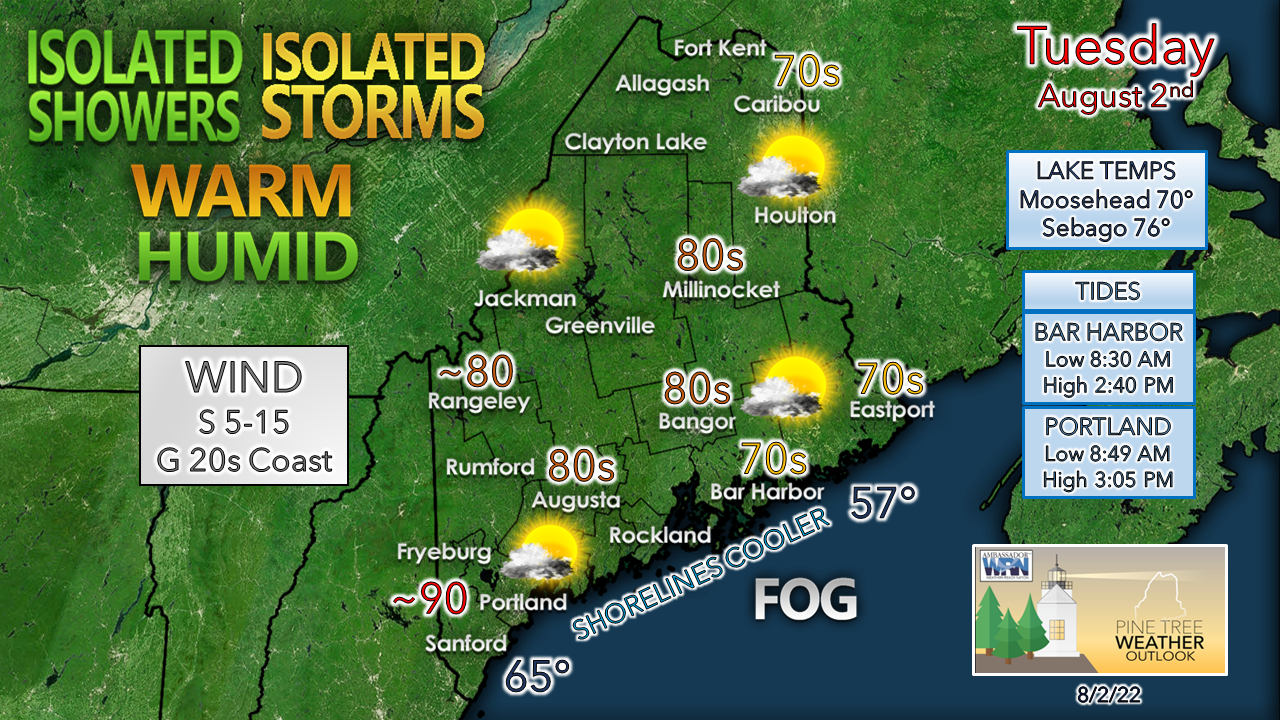
A southerly flow will drive dew points into sultry levels in the upper 60s to low 70s. Shorelines east of Portland could be dealing with fog most of the day. The 70s forecast for DownEast areas may bust if the fog holds on, with highs topping out in the 60s there.  Southwest interior areas could hit 90°. Folks headed for the beach should perch early as the mid-afternoon high tide cuts down on available space. 

After the cold front passes through, it takes the edge off dew point temperatures, but the moisture in the air is likely to be noticed over the coastal plain Wednesday. 

A roaster on the way Thursday, potluck showers
​and storms possible through the weekend

Picture
Thursday 2 AM to Sunday 8 PM - One long loop here shows one striking element we haven't seen too much this summer and that is the Bermuda High setting up. That scenario pumps heat and humidity into the region for Thursday, which many areas can expect a heat advisory along with air-you-can-wear, and poor air quality. While a cold front approaches from the west, it appears that it could stall out and hang around through the weekend. This helps to increase rain chances, but also severe storm chances as well. As long as the Bermuda High hangs on, the humidity will also, and at this point, it appears to be uncomfortable and gross for much of the region through Monday.  
Picture

​Thank you for supporting this community-based weather information source which operates by financial contributions from people like you. 
​
Stay updated, stay on alert, and stay safe!

NEXT UPDATE: THURSDAY

- Mike

​NOTE: The forecast information depicted on this platform is for general information purposes only for the public and is not designed or intended for commercial use. For those seeking pinpoint weather information for business operations, you should use a private sector source. For information about where to find commercial forecasters to assist your business, please message me and I will be happy to help you.

Comments
    Picture

    Mike Haggett
    Kennebunk, ME

    Certified Weather
    Forecaster
    Penn State '21

    American Meteorological Society

    National Weather Association

    Weather-Ready Nation 
    Ambassador
    ​
    ​SKYWARN-CWOP

    Matthew 19:26


    Support
    Pine Tree Weather

    DONATE

    Picture

    Picture

    Picture

    Picture

    Picture

    Picture

    Picture

    Picture

    Picture

    Picture

    Archives

    January 2023
    December 2022
    November 2022
    October 2022
    September 2022
    August 2022
    July 2022
    June 2022
    May 2022
    April 2022
    March 2022
    February 2022
    January 2022
    December 2021
    November 2021
    October 2021
    September 2021
    August 2021
    July 2021
    June 2021
    May 2021
    April 2021
    March 2021
    February 2021
    January 2021
    December 2020
    November 2020
    October 2020
    September 2020
    August 2020
    July 2020
    June 2020
    May 2020
    April 2020
    March 2020
    February 2020
    January 2020
    December 2019
    November 2019
    October 2019
    September 2019
    August 2019
    July 2019
    June 2019
    May 2019
    April 2019
    March 2019
    February 2019
    January 2019
    December 2018
    November 2018
    October 2018
    September 2018
    August 2018
    July 2018
    June 2018
    May 2018
    April 2018
    March 2018
    February 2018
    January 2018
    December 2017
    November 2017
    October 2017

    RSS Feed

Proudly powered by Weebly