Steady rain moves out Friday morning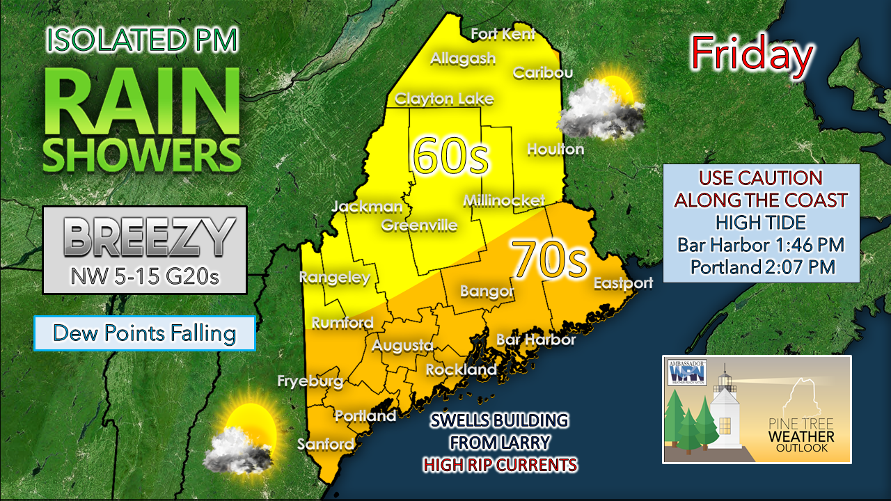 As the frontal boundary slides to the east on Friday, conditions will begin to improve from west to east as the day progresses. The wind from the northwest will pick up and clear out this round of humid air during the afternoon. It will be a great night to open the windows and rest with comfortable temperatures. 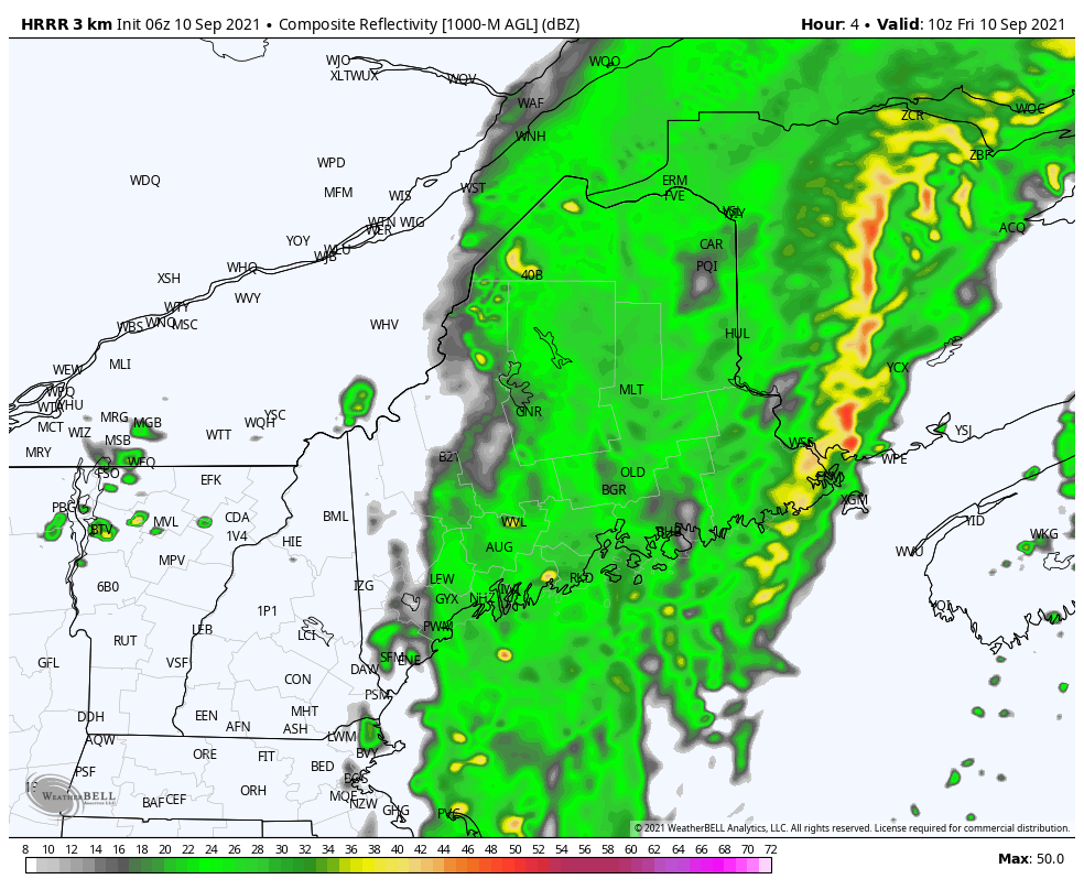 This forecast loop from 5 AM to 10 PM shows the steady rain departing east. An axis of an upper-level trough passes overhead in the afternoon, which will bring the risk of an isolated shower through the evening hours. The sky clears out as the afternoon progresses into the evening. Larry passes to the east Friday afternoon An already large Hurricane Larry continues to expand as it gains in latitude. The storm is on track due east of Maine around 2 PM Friday afternoon on its way to hammer Newfoundland Friday night into early Saturday. While the storm is technically weakening, what is deceptive with that notion is the wind field is expanding.  Highlighting once again the guidance from the US Navy with the storm, the 34-knot wind field encompasses northeastern Nova Scotia and all of Newfoundland. As it heads for Greenland by Sunday, the wind field continues to increase in size. Hurricane warnings are in effect for the Avalon peninsula including St. John's. Hurricane force wind, big surf and storm surge will be the major concerns with this storm. For more information on this, please monitor The Weather Network, NTV News in St. John's, and my list of Canadian weather coverage on Twitter.  When big surf is in the forecast, it brings spectators to the shorelines to see the awesome power of the ocean in action. While it is great to get that epic photo, stay smart and view from a distance. Along with the power comes unpredictability of wave heights. Respect the conditions and stay safe. Weekend outlook Saturday will be the pick of the weekend with mainly sunny conditions, a bit of a breeze, and comfortable temperatures. A frontal boundary approaches from the northwest on Sunday, which will increase clouds, bring humidity levels back up for the coastal plain, and bring a chance for showers primarily for the north and mountains. The front drops south of the region by Sunday night, reducing humidity levels for all but southern areas by Sunday night. The front appears to stall over Southern New England on Monday, which keeps clouds around for southern Maine, with perhaps a risk of a shower for York County. Sun appears more prevalent to the north and east. Rain potential midweek A warm front in on track to move northeast on Tuesday followed by a cold front passing through on Wednesday which gives the region the next chance for rain. Stay tuned for fine tuning on details on this potential early next week.  Temperature outlook through WednesdayThe string of above normal temperature nights continues for the region, except for northern areas on Tuesday waking up to a couple of degrees below normal. Temperatures other than Tuesday run above normal statewide through the middle part of the week. 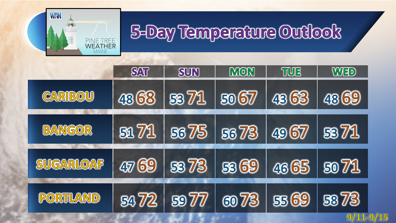 Be prepared to receive alerts and stay updated!
For more information in between posts, please follow Pine Tree Weather on Facebook and Twitter.
Thank you for supporting this community-based weather information source which operates by reader supported financial contributions. Stay updated, stay on alert, and stay safe! - Mike |

Mike Haggett
|