
|
At the time of this post on Tuesday afternoon, power outages from the previous storm were down to 1,914, which is fantastic news. Hopefully the power crews can get everyone back online and get a bit of a break before this next one arrives late week. They are going to need it. I appreciate all the new followers. I hope you like what I do here and hang around for a while. You want to make sure that you FOLLOW the Facebook page so you can get the latest information from me. Check the pinned post for how to do that if you are not sure. If you give it a "like" also for posterity sake, I appreciate that. For those on Twitter, you can check my timeline anytime and look for the pinned tweet at the top of my page for my latest post. I am funded by those who follow here and support my semi-professional hobby. I am short $900 for the year. As soon as the bills are covered for 2023 I'll stop talking about needing money, which is something I don't like to do, but if I am going to continue, it will be because of the funding supplied by those like what I do and appreciate my long hours of effort. A big one on the way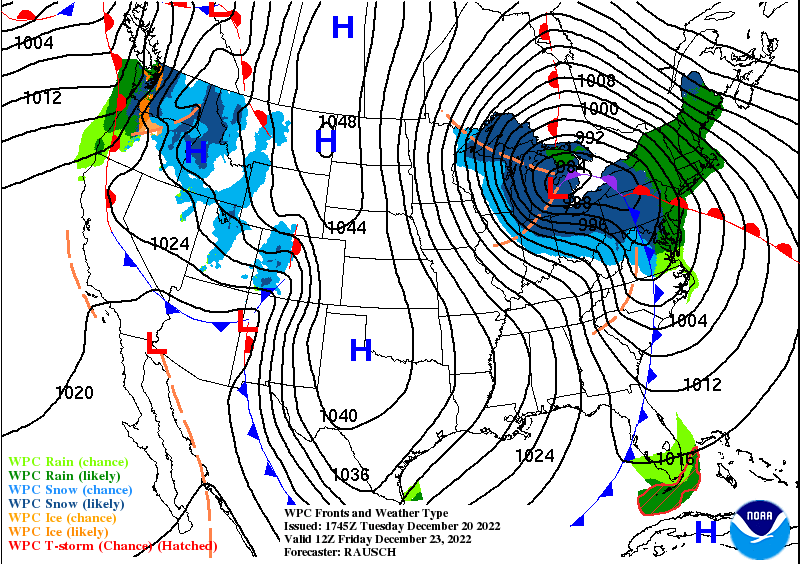 Weather Prediction Center forecast idea for 7 AM Friday It's not very often we get a Great Lakes bomber, but that is what we have on tap here. The Siberian Express made landfall over the Pacific northwest and heading south and east. Anytime you have big cold running up against warm, the two don't get along very well. In the atmosphere, it's gasoline and a lit match. Big storms aren't uncommon in winter, but where this one fires up is more like something seen in spring, sort of Colorado Low-esque in development. This is classic bombogenesis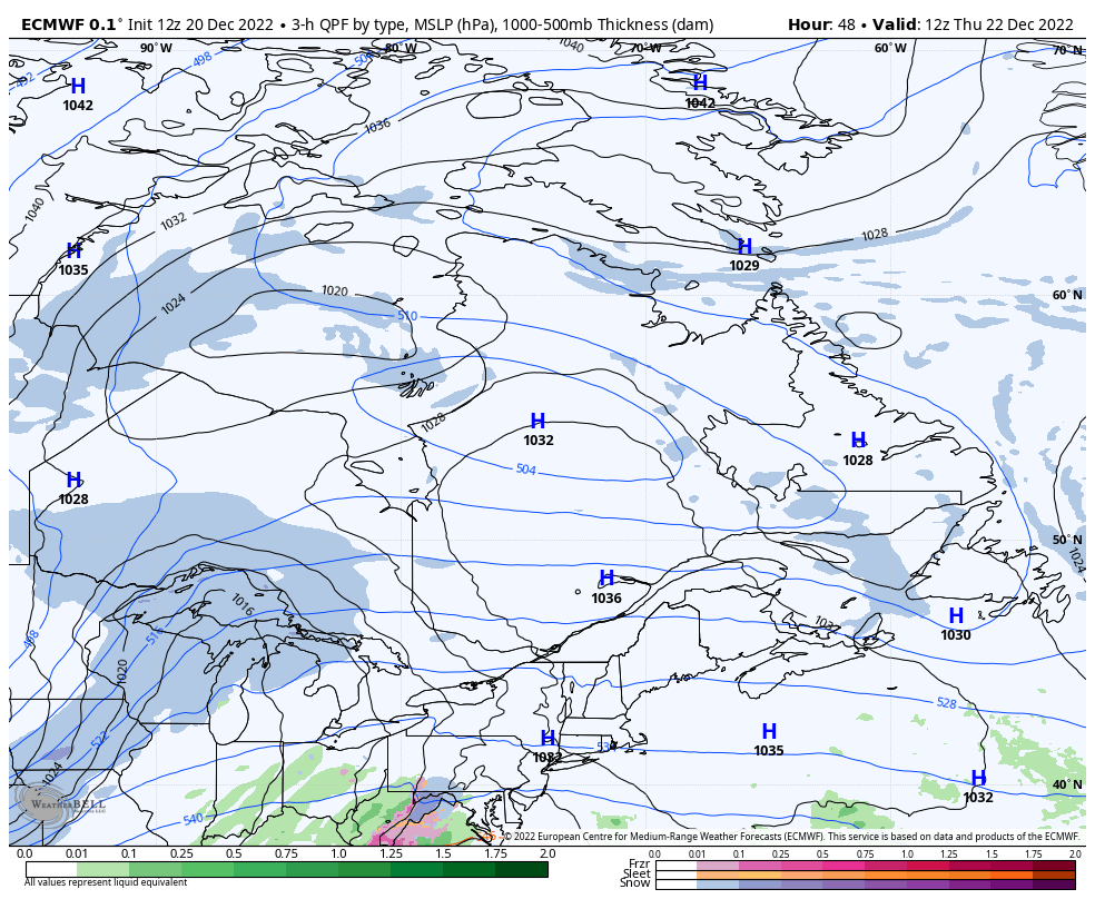 Thursday 7 AM to Saturday 7 AM - I don't like using terms like "Bomb Cyclone" that the media has hijacked off the meteorological term "bombogenesis," but I have to call a spade for what it is here. The arctic blast meets ridge moving north from the southwest, the two don't like each other, and an atmospheric war breaks out. Bombogenesis is the term for rapidly developing synoptic storms that fall in barometric pressure by 30 millibars within 24 hours. What looks like nothing over the central Plains at 7 AM Thursday turns into a whole lot of something by 1 AM Friday, and it continues to intensify during the day. From 1000mb to around 965mb is an incredible drop in a 24-hour span and why it is critically important to take this storm with respect. The wrinkle in the forecast that became more consistent today can be seen with high pressure to the northeast bleeding cold air over western and northern areas. This sets up a cold air damming situation. The storm track has moved more to the east. 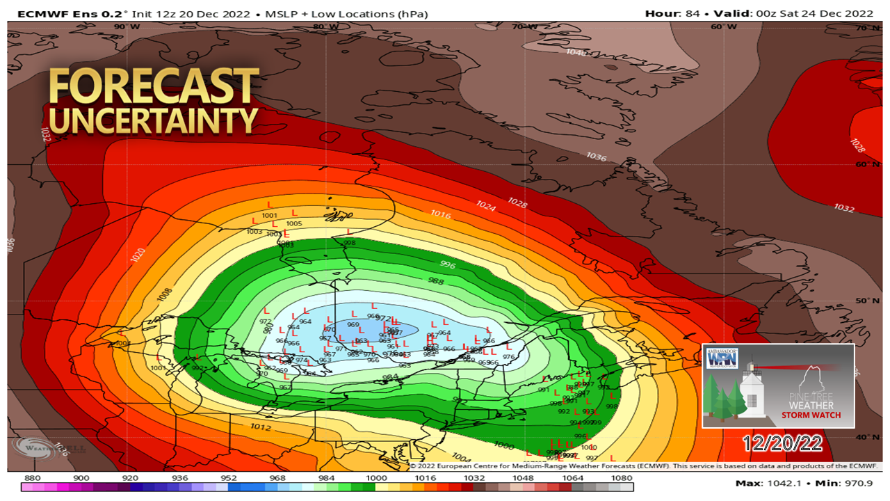 I present this graphic of the European ensembles to make the point that there are still time for changes here. The basic idea of what to expect has been realized at this point. The fine tuning is to come and expect adjustments. Southeast wind events can bring high impacts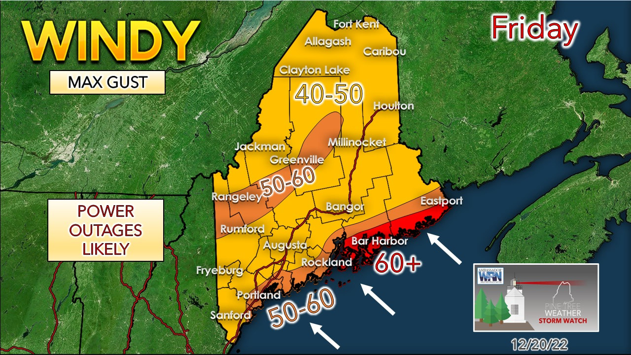 The thing with the rapid development of storms is the wind. It's more concerning when the wind comes out of the southeast as tropical moisture is feeding into it, as in the case here. While this isn't the October Gale of 2017, and not even close to that in dynamics, this storm could feature a low-level jet in the 60-80+ knot range, which at that level translates to 40-60+ wind gusts when it mixes down to the surface. For now the highest gusts are expected from Penobscot Bay and DownEast. There is about a 12-15 hour window from Friday morning to mid-Friday evening for Rockland to Kittery and from mid-morning Friday to around midnight Saturday for the eastern areas. There is no doubt power outages are on the discussion table here. The track and intensity of the storm plays a large hand on if the gusts increase or perhaps decrease a bit, but the ideas of the past two days have formulated this idea for now. Precipitation and flood potential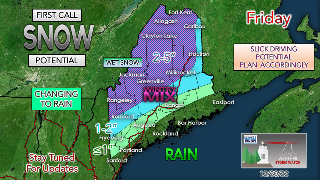 With the likelihood of cold air damming and a shift east in track has me formulating this snowfall idea. High pressure to the north could bleed cold air over the north at the onset and bring some snow, a bit of sleet, but also a concern for some freezing rain before the warm air gains superiority. It could be a sloppy, slick start over western areas. Cold air damming potential brings the risk for pockets of freezing rain and drizzle to form. Since this is a southeast wind flow attached to a rapid developing storm to the west / northwest, I don't expect the cold air damming to hang on during the main event of the storm Friday afternoon. The far north may deal with the mix and slop into the afternoon, but as the low level jet cranks and the storm shifts, all areas are likely to go to rain, and heavy rain at that, before it ends overnight into Saturday. Any moderations in track may bring snow and freezing rain closer to the coast or further away. This will be updated. On the subject of snow... 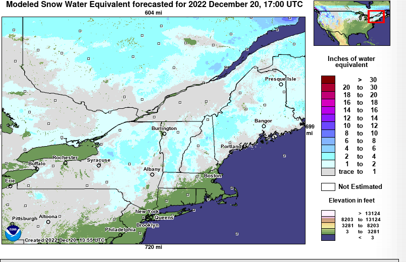 This important graphic here from the New England River Forecast Center shows an estimate amount of water that is frozen in the snow. Interior areas that got hammered with big snow last weekend are showing roughly 2-4" of water content in frozen form. This is key for what is coming for rain and warm air. 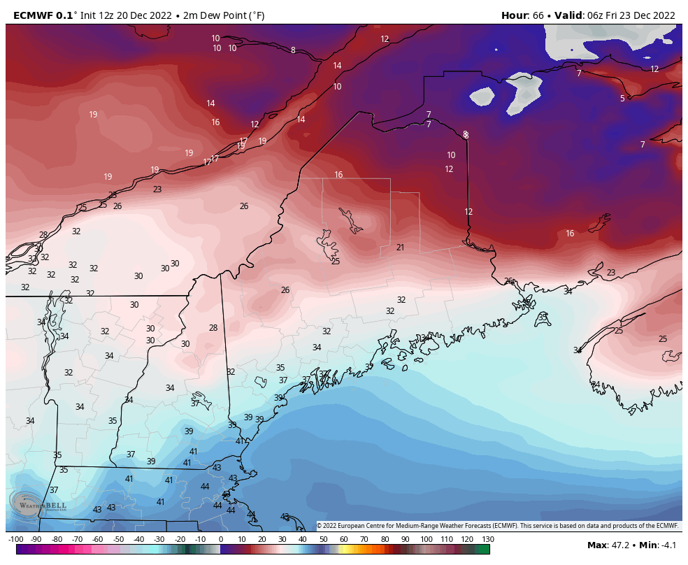 Friday 1 AM to Saturday 7 AM - There are a couple important things here. First off is the rise in dew points. This shuts off the areas of freezing rain and snow over the interior with the surge of moisture from the south/southeast. This also ripens the snow on the ground and initiates melting. The good news here for ski country is I think the shift east in the forecast - if it holds - cuts down on the loss of the snowpack on the hills. The snow that is there should absorb quite a bit of this rain (hence why I told you folks the shovel your roof off in areas that got blitzed last weekend... if you have more than a foot of snow on your roof YOU NEED TO GET IT OFF). The other piece her is the flash freeze on the backside as cold air enters in from the southwest. It's a rather odd direction as it usually enters in from the northwest, but with the track of the storm heading for Hudson Bay, this is how the cold front enters in. 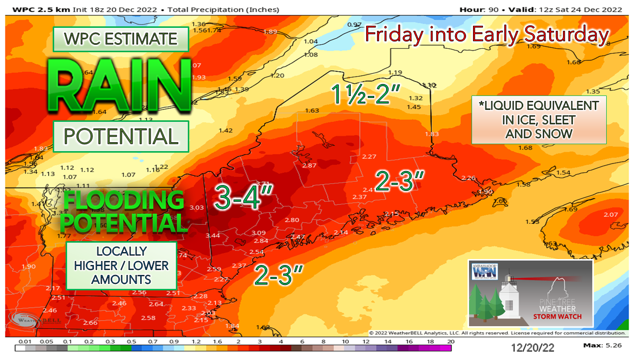 Forecast rain ideas have been holding firm for two days now. The combination of the snow melt and a blast of tropical moisture brings the potential for brooks, streams, rivers, roadways and basements to flood. No power, no generator, no sump pump, or if you have a leaky basement is no bueño with this one. Expect more details on the extent of flood potential in the next couple of days. Then there is the ocean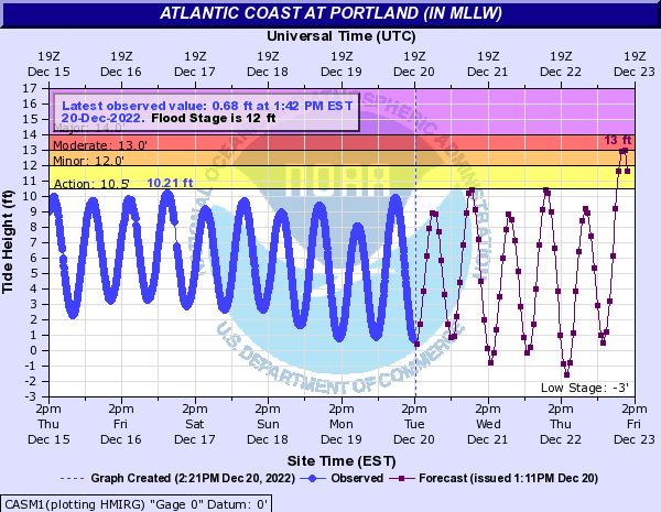 The timing game of the strongest winds plays a significant role on if the shorelines flood or not. If ideas hold that the strongest gusts work through Friday afternoon, that may spare the shorelines the worst. High tide around 10 AM Friday is the highest of the two highs, and tides are astronomically high with the new moon. With the low tide at around 4 PM Friday afternoon, that helps cut down on the shoreline threat somewhat. I do expect seas in he 15-20' range and 1-3' of storm surge. Low tide may look like half tide. The coastline is likely to get abused, but time will tell just how bad. Stay tuned! Funding deficit for 2023 ... $900 Thank you as always for your support! You may not like the weather, but I hope you like what I do! Please hit the like button on Twitter and Facebook, and share! Stay updated, stay on alert, and stay safe! - Mike NOTE: The forecast information depicted on this platform is for general information purposes only for the public and is not designed or intended for commercial use. For those seeking pinpoint weather information for business operations, you should use a private sector source. For information about where to find commercial forecasters to assist your business, please message me and I will be happy to help you. |

Mike Haggett
|


