
Storm heads to slam Nova Scotia, to glance Maine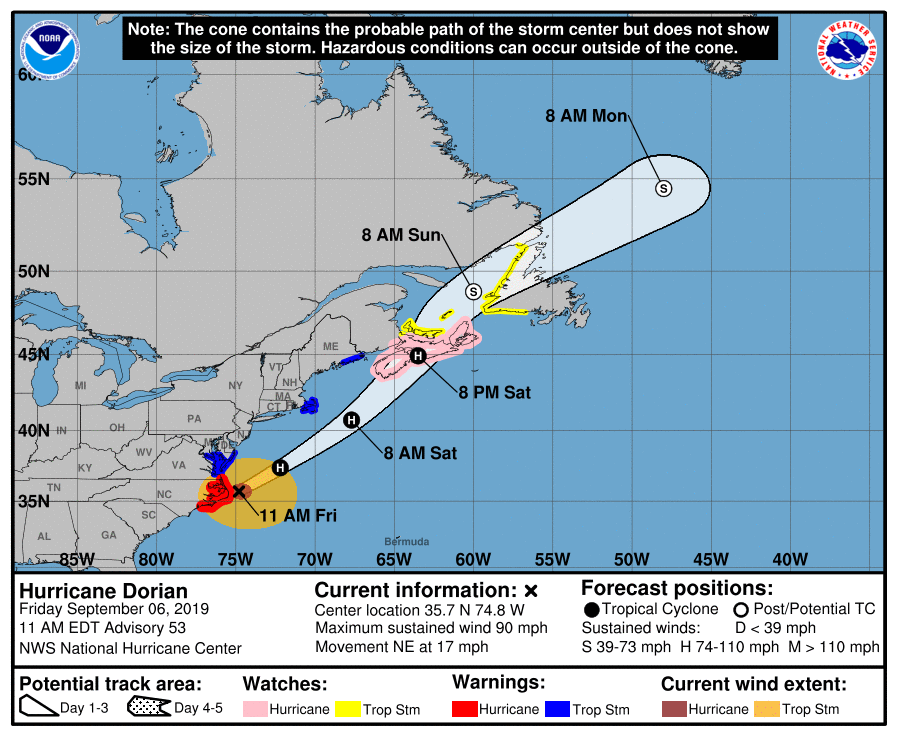 As Dorian breaks away from Cape Hatteras where it made official landfall Friday morning, the storm will accelerate quickly south of New England and head straight for the east coast of Nova Scotia. The storm appears on track to make landfall east of Halifax late Saturday afternoon. From there, it will take on and extratropical form, looking more like a NorEaster as moves towards Newfoundland on Sunday. Coastal areas to get the higher wind gusts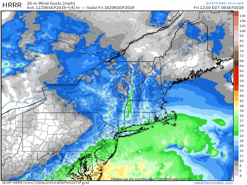 This loop from noon Friday through 8 PM Saturday shows wind speeds building along the shorelines, first from the northeast Friday afternoon and night, then to the northwest on Saturday as the storm passes to the southeast of the region. Wind gusts of 15-25 mph for the southwest coast are possible, with gusts in the 30 mph range along the immediate shoreline. For DownEast interests, gusts appear to build in the 25-35 mph range, with gusts in the 40-50 mph range possible for the Jonesport / Calais / Eastport region around mid Saturday afternoon into early Saturday evening. It appears to be breezy enough to cause some tree and other debris to go airborne. It would be suggested for all inhabitants of the coastal plain to secure any objects which could go airborne as a precaution in case higher gusts come in any downpours or heavier showers. Most of the region to see some shower activity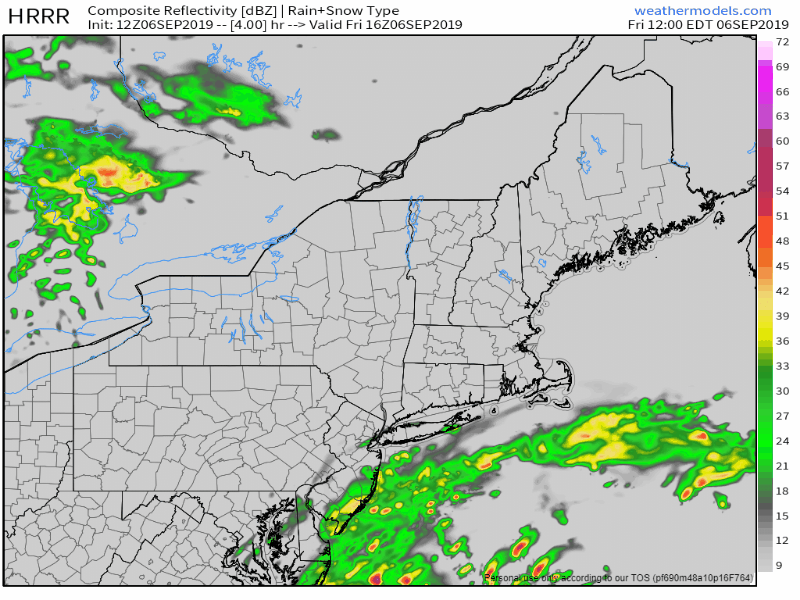 Timing of rain arrival of the storm comes mid-Friday evening for the southwest coast, and will overspread western and eastern areas overnight. Far northeastern areas up in The County see rain arrive Saturday morning. Steadier rain tapers to isolated showers for western and southern areas by Saturday afternoon, northern and eastern areas Saturday evening. A trailing inverted trough may bring some spot shower activity overnight into early Sunday morning. 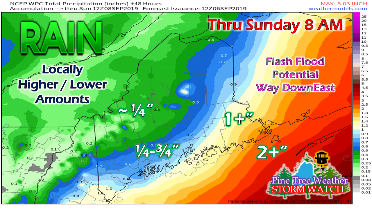 As with the higher wind speeds, the coastal areas are likely to see the most rainfall from Dorian. Rain could be heavy at times, which could cause ponding on roadways and potential hydroplane issues and reduced visibility on the highways. DownEast areas have the best chance for flash flood potential. Creeks and ditches could rise very quickly from torrential rainfall. For areas southwest of Penobscot Bay, any flash flooding is likely to be localized. High Surf Advisory for the shorelines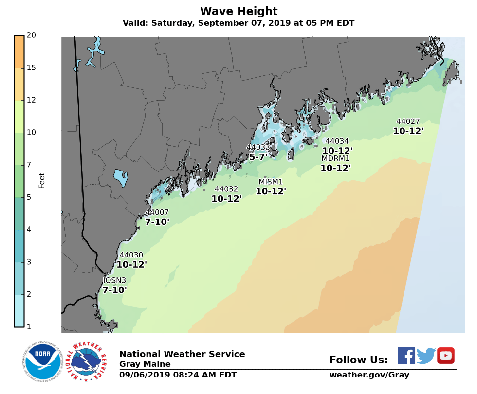 Exposed shorelines could see average wave heights in the 10-12' range, but could go higher with swells. This dynamic also sets up a high risk for dangerous rip currents. It would be of best interest to observe any ocean activity from a safe distance. A 1-2' storm surge is possible for DownEast areas with the Saturday evening high tide in the 6:00 hour. With the moon cycle off astronomical highs, that reduces the threat for coastal flooding somewhat, but it cannot be completely ruled out. People along the coast of Hancock and Washington Counties should check for bulletins from the National Weather Service Caribou in case that changes. A special thanks to the National Weather Service Gray office for providing this graphic. Stay on alert for bulletins and updates!►► Latest forecast from the National Hurricane Center for Dorian.
► ► For the latest official forecasts, bulletins and advisories, please check in with the National Weather Service in Gray for western and southern areas, or Caribou for northern and eastern parts of Maine. Please consider supporting Pine Tree Weather ► ► Your financial donations are much appreciated to keep this site funded and for further development. FUNDRAISING NOW FOR 2020 PLEASE SUPPORT! I sincerely appreciate your support not only financially, but also in sharing my efforts with others. For more information from me, please check the Pine Tree Weather Facebook page as well as my Twitter feed. Always stay weather aware! - Mike |

Mike Haggett
|


