
|
I hope you had a chance to get out and enjoy the beautiful weather over the weekend. Whether some spring skiing, a hike, a walk on the beach or around the neighborhood, it was a great period of weather to get out. I am still grinding away with college but managed to take a break and walk the beach with my wife and Bud on Saturday and swung at the first golf balls of the season at a driving range late Sunday afternoon. I am in the final stretch to wrap up my studies with Penn State. Pending on how things go, I could be done within the next two to three weeks. Until I finish, my updates will be sporadic. This has been my best semester grade point wise and I want to finish strong, so my energy and time will go into that. I will update here, on Facebook or Twitter when warranted. A dry start to the year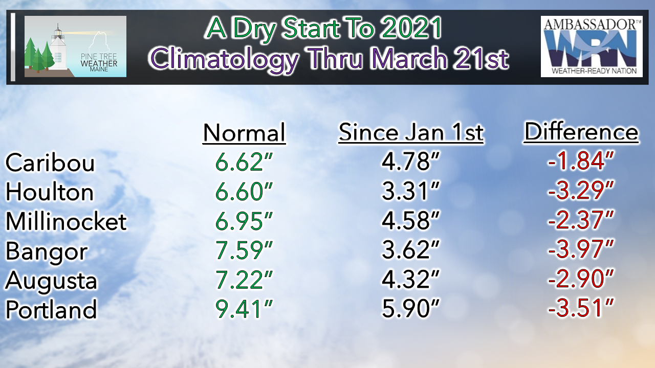 Ever since I started this peanut whistle operation in 2012, drought has been the main storyline of any I have used. We're off to a lean start once again. The state saw less snow in most areas. Caribou has seen 94" of snow to date, which is 2" below normal. Portland has recorded 41" of snow for the season, which is 15" below normal. Whether frozen or liquid, it does impact the hydrology amounts overall. The snow has been fluffier in northern areas, which means less water content. All areas start spring with a deficit. April appears at this point to bring average rainfall from what the long-term ideas are presenting for now, which if that is true is encouraging. The upside is mud season would be shorter, and spring flood concerns would be less impactful. The downside is we may need to get the hoses out early for the gardens and the lawns, and for those who rely on ground water resources for their necessities will have to watch the wells. 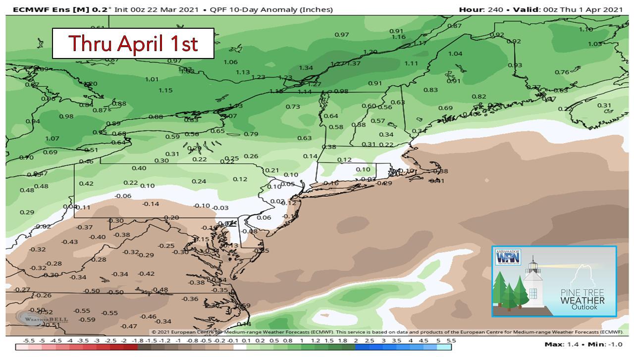 While the early part of the week appears dry, the trend is damper as we head into late week and into early next week. 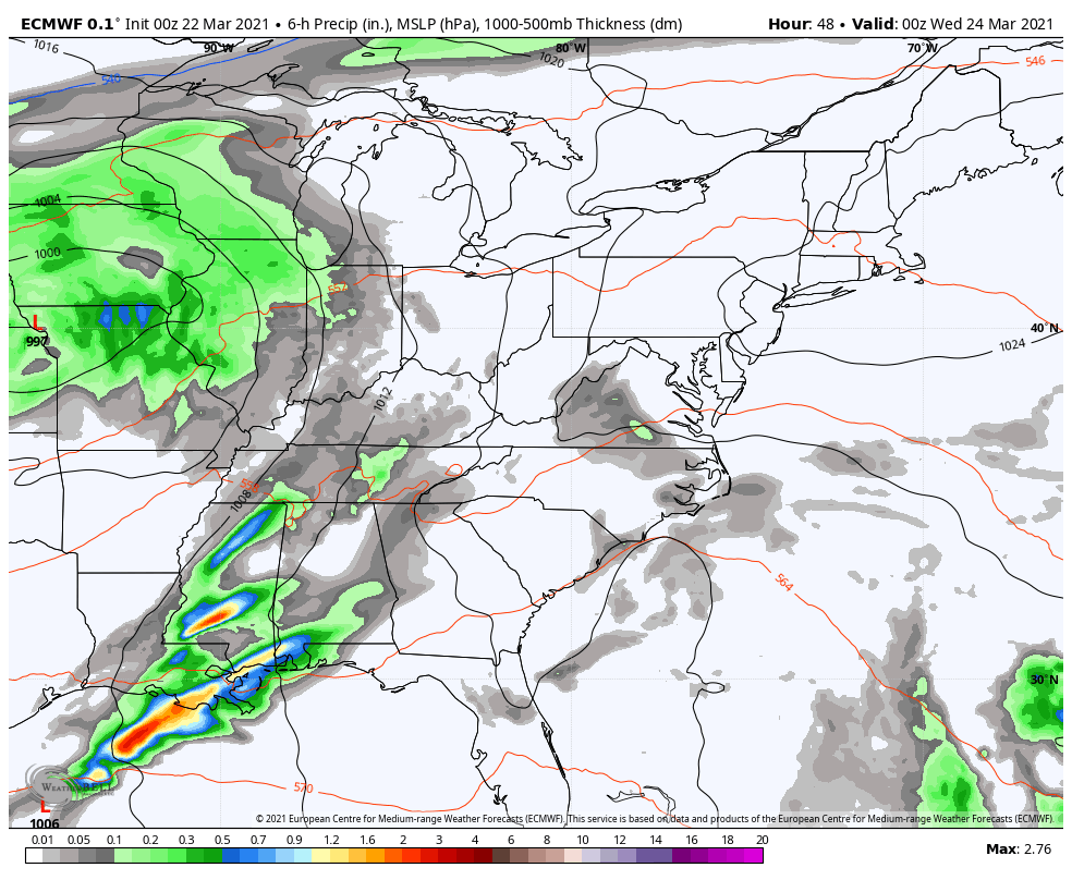 Thursday, a warm front moves northeast and brings the chance for showers. A more widespread event appears likely as we head into the weekend. The deterministic ideas are struggling to deal with cold air over Quebec, so there are flip-flopping ideas going on. Coastal rain is the safe bet for now. For the mountains and north, there could be a mix to contend with. Stay tuned for updates on that. 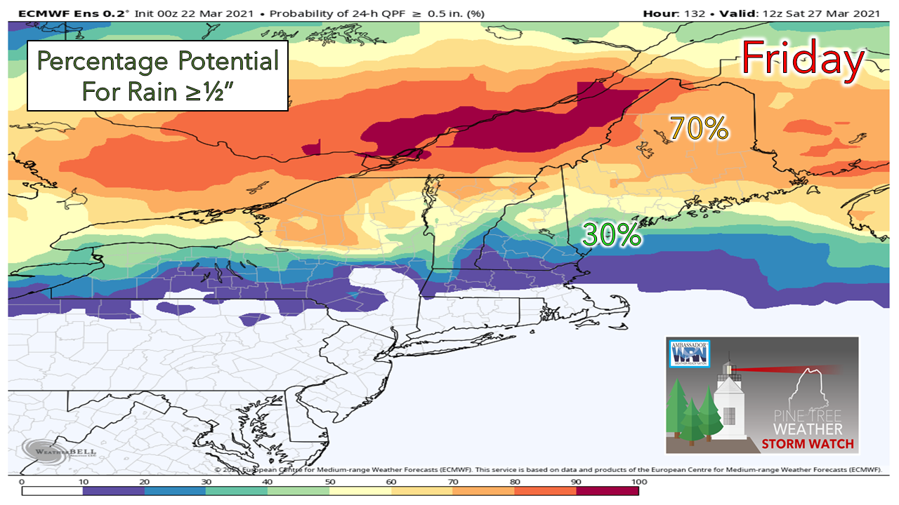 At this point, there does not appear to be a whole lot of liquid to contend with. Best chance for ½" of liquid equivalent for northern areas, with less of a chance south. It's something, and we'll start with that. Looking ahead into next week, a trough appears to drop down from the north. The timing of it is still to be determined. That potential late March / April Fools storm is on the radar. It's too far out to give any confidence on if or what may come of it. For those curious, I am not sticking a fork in winter just yet. It's March 22nd. There are signals out there for cooler temperatures aloft to stay mindful of. We had snow in May last year. While I am not predicting a repeat performance of that, there is too much cold to the north to dismiss snow chances just yet, even for the coast. Has it been windier than normal?This is a common question I have been asked for a few years now. With our storms being strong and packing wind which causes power outages, I can understand the sensitivity to it. March tends to be a breezy month in general with the change of seasons. Looking at the north and south, the average speeds are running below average. 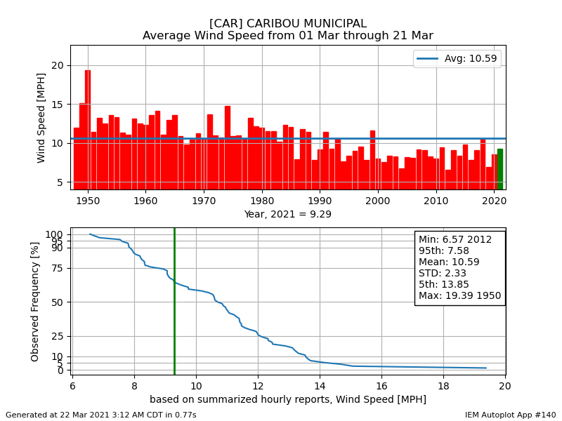 Caribou has not had an above average month for wind speed since 1999. The March of 2018 has been the breeziest since the flip of the century. 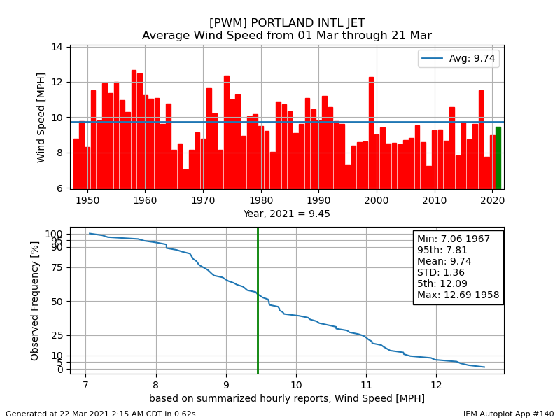 March of 2018 was the last time that Portland was higher than average for the month. The only other March that has been above normal since 2000 is 2013. These numbers may nudge up a bit as the pattern gets stormier over the weekend and into next week, but confidence is good that the March of 2021 will go into the books with slightly below normal wind speeds. Temperatures on the warm side through the weekAs you look at these temperature forecasts, I have anointed into each the typical high and low for the beginning and end of the period. Caribou has a chance of breaking a record high on Tuesday (60° in 1979) but other than that, the records will hold everywhere else. While it will be warm to start the week, the trend is cooler to more typical values by the weekend. For those who have ice shacks on the lakes or ponds, it's time to pull them off if you have not already done so. 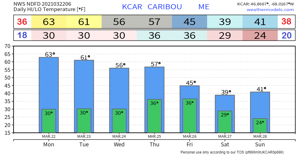 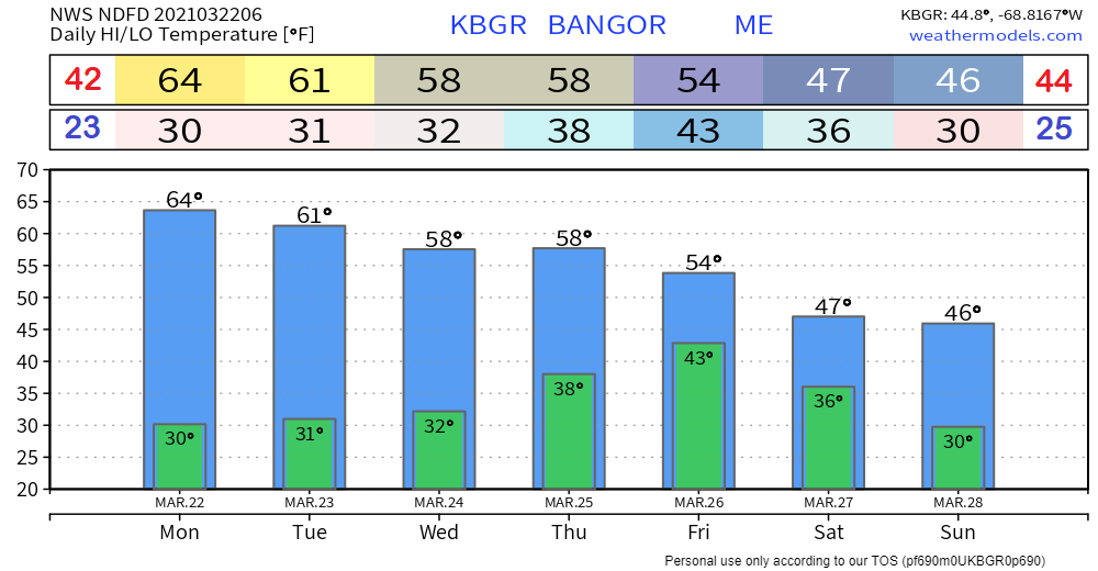 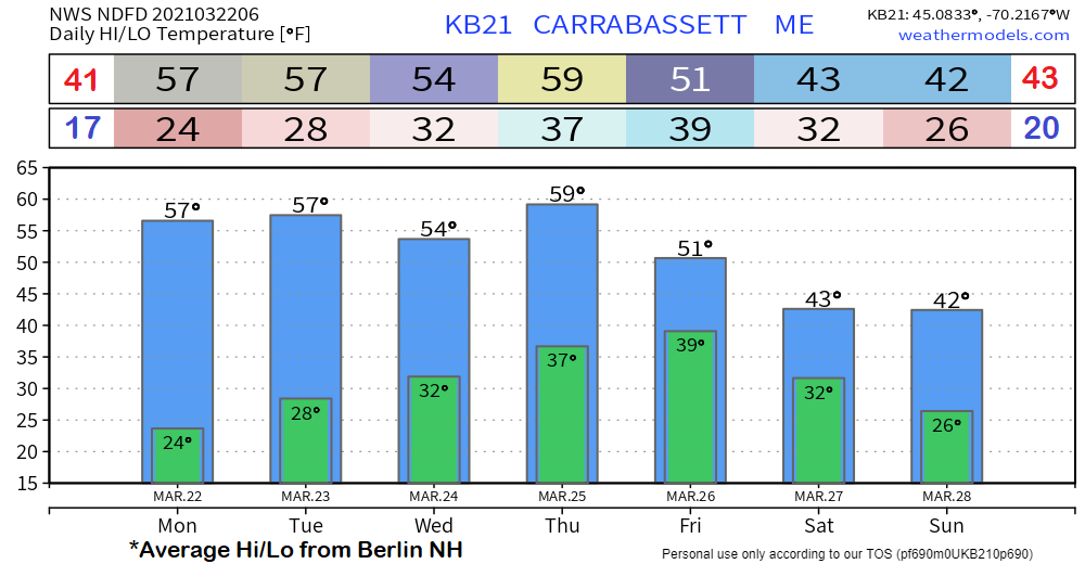 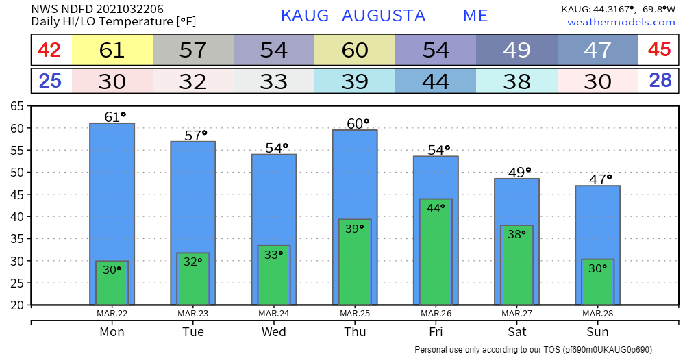 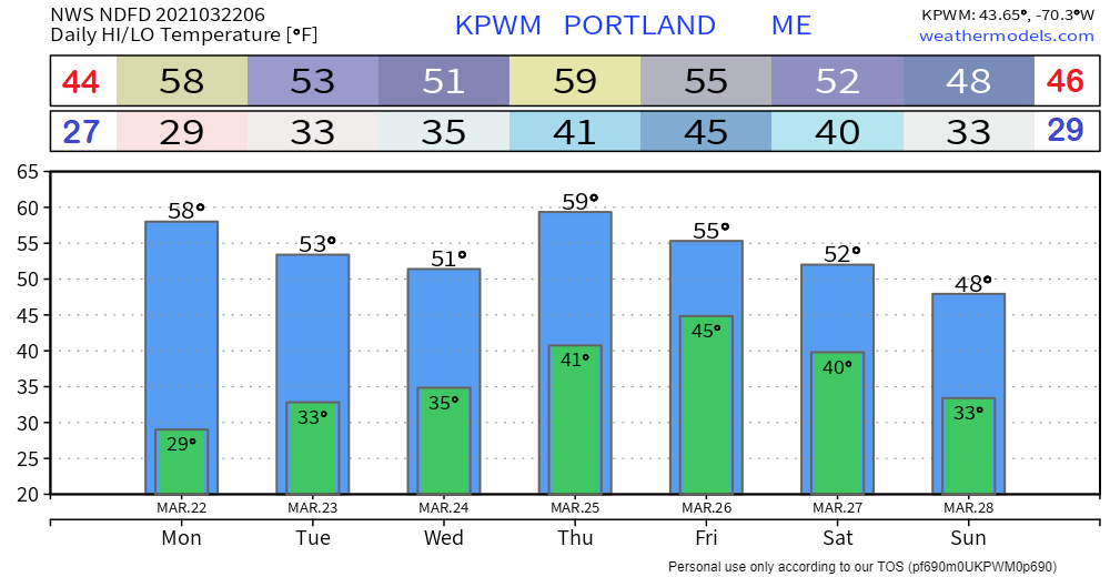 CoCoRaHS observers wanted!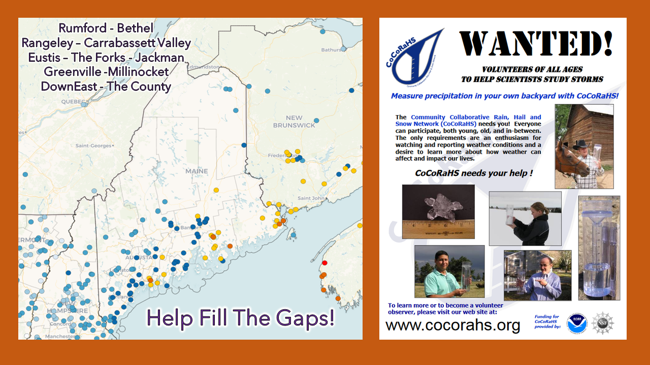 For folks in western, eastern, and northern areas, the Community Collaborative Rain, Hail and Snow Network could use your support! Verification of precipitation is especially important to improve forecasts. All ages can participate. Reporting is easy, and it takes little time to do. For more information, please check the CoCoRaHS Maine website. I would be more than happy to answer any questions you may have about the program! Be prepared to receive alerts and stay updated!
For more information in between posts, please follow Pine Tree Weather on Facebook and Twitter.
Thank you for supporting this community-based weather information source which operates by reader supported financial contributions. Stay updated, stay on alert, and stay safe! Thank you as always for your support! - Mike |

Mike Haggett
|


