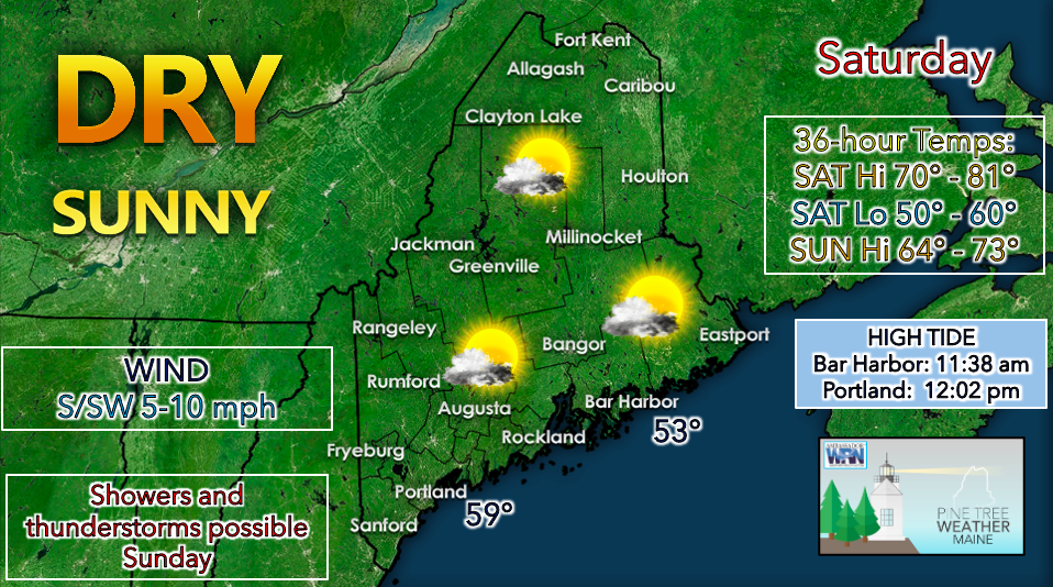
 Saturday will feature clear and sunny skies as upper-level ridging takes place and an associated surface high settles over the region. Some folks may be waking up to patchy fog this morning, and even denser bands of fog for those that received rain on Friday evening. Use caution if you are out driving. This should clear out by mid to late morning, giving way to few clouds and plentiful sunshine. The National Weather Service has issued a BEACH HAZARDS STATEMENT for coastal Hancock and Washington counties. Despite the beautiful weather, it is important to remember that the ocean water is dangerously cold in these areas. Check with local authorities if you are unsure about what activities are safe. High temperatures on Saturday will likely reach the upper 70s to lower 80s statewide. Humidity does not appear to be an issue as dew points stay comfortable in the 50s. Winds are projected to start out calm before turning southerly and southwesterly during the afternoon at 5-10 mph. This should allow for a sea breeze to take form along the coast, resulting in cooler temperatures in these locations. Saturday night appears relatively cool, with low temperatures dropping to the 50s. The mountains and areas far north could potentially dip into the upper 40s. Clouds are likely to build overnight throughout the state as a frontal system approaches from the west. The upper level ridge is expected to move off to the east, setting the stage for more unsettled conditions on Sunday. Sunday looks to begin with widespread showers as a warm front approaches the state. There is some uncertainty regarding which areas might receive afternoon thunderstorms, but the threat currently looms largest in western areas. Locations that see sufficient diurnal heating will have the best chance of seeing convective activity on Sunday afternoon. Some models are indicating strong wind shear which could result in more intense storms. Be sure to check back on Sunday morning for an update on the convective outlook. Unsettled conditions appear to be in store early next week as an upper-level trough takes place across our region, resulting in cooler air aloft. Afternoon showers and thunderstorms initiated by diurnal heating will be possible on both Monday and Tuesday. Be prepared to receive alerts and stay updated!
For more information in between posts, please follow Pine Tree Weather on Facebook and Twitter.
Thank you for supporting this community-based weather information source which operates by reader supported financial contributions. Stay updated, stay on alert, and stay safe! |

Mike Haggett
|