
The pieces are all coming together The four main ingredients for the mid-week storm are falling into place. Water vapor imagery shows the parcels of upper level energy descending into the southeast. The elements are on track to gather together by Wednesday morning. A surface low develops near the DelMarVa and then travels northeast. Snow will begin to impact southwestern areas by late afternoon, overspread the state by late Wednesday night. Snow is on track to fall heavy at times into Thursday morning, then taper to snow showers from southwest to northeast through Thursday night. First call snow amounts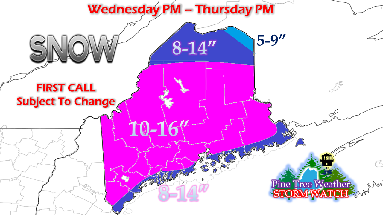 For the shorelines, be aware of the coastal front. I am thinking that areas west of Penobscot Bay (MidCoast, Southwest Coast) may see a rain/snow mix at the onset and then flip to rain by mid to late evening and stay snow for the duration of the event. DownEast areas start as snow and then flip to rain briefly Thursday morning. This will knock down snow amounts a bit. Most of the interior areas are a lock for roughly a foot or more, with the possible exception of northeastern Aroostook. It would not surprise me to see some areas eclipse 20". Time will tell if that will an exception, or the rule. On the subject of The County... snow showers in the aftermath of this storm are likely to drive snow totals up to what the rest of most of the state gets initially. Snow showers are going to linger around through Saturday morning, perhaps longer. Expect a laundry list of storm related cancellations Thursday. It will take some time to dig out and get the roads passable for travel. Again, this a preliminary outlook and is subject to change. Windy, but not exactly "blizzard" level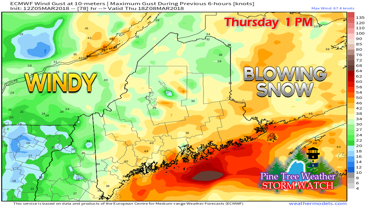 As with any developing storm, wind is always a concern. In this case, most of the snow appears to be on the ground before the wind begins to crank in earnest Thursday morning. Eastern areas are likely to see the strongest gusts as low pressure approaches. Make no mistake, the wind will blow snow around which will likely cause whiteout conditions at times from the beginning to the end of the event. As heavy as the storm will dump snow, it may feel and look like a blizzard, but the idea that it will reach criteria of wind in excess of 35 mph for a three hour period does not appear likely. The wind does appear that it could hamper clean up efforts, and expect that to blow all day. Heavy snow that sticks to trees may cause power outages with what wind comes along. Those outages may not occur until Thursday morning or later. It appears to be breezy through Friday morning over western and southern areas, Friday night for northern and eastern areas. Shorelines get hammered again...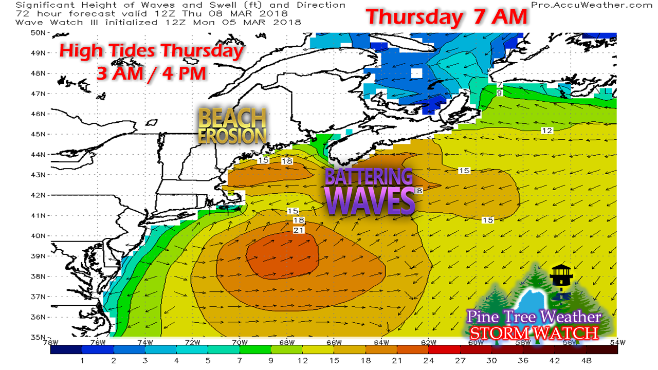 The good news is the tides will have dropped considerably from their recent astronomical highs, and this storm does not appear to have the intensity of its predecessor. That said, the wounded coastline will have to deal with another round of high surf and wind during the day on Thursday. The two high tides to be concerned with happen during the 3 AM hour Thursday morning, with another happening around 4 PM in the afternoon. I am not expecting any major flood issues, but some minor flooding is possible. Areas impacted from recent floods should be on alert where the ocean has impacted barriers, sea walls, and roadways.
As always, stay in touch with NWS Gray or NWS Caribou for the latest bulletins and forecast information. - Mike |

Mike Haggett
|


