
Another Monday storm to bring rain, wind, and coastal concernsI mentioned in Wednesday's post that it would be Saturday before specific details would start to fall into place. The reason being for that is all of the pieces need to be in range of radiosonde (weather balloon) airspace to gather the data necessary to fine tune the forecast. While there is good reasons to believe that the area will receive another round of heavy rain, the wind aspect is still to be properly defined. As we saw with the storm last Monday, the wind threat under performed overall. Sure, there was expected wind damage over MidCoast and DownEast areas, but the forecast wind speeds didn't make it to the levels predicted. While this storm is a different animal, there is wiggle room here. 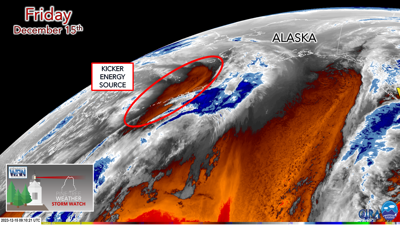 Guidance has been a bit jumpy with this forecast system all week. Part of it is this piece to the puzzle seen above here. This is the dealer at the blackjack table. It holds the cards on storm track and intensity. Looking at the loop below of the 500mb vorticity (upper level motion), look at the Aleutian Islands at the top left corner and watch the evolution of it.  This piece causes the chain reaction that sets everything into motion in regards to the storm. As the upper low over the Midwest taps into Gulf moisture as it heads east, the kicker energy dives to the south and sets a hook into the system and drags it north. By mid-afternoon on Monday, that energy is just east of the Mississippi River valley, with a Miller "B" type nor'easter system impacting the Great Lakes region. 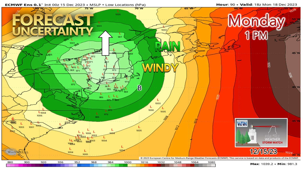 Since that kicker energy is outside of weather balloon range and will be until Saturday, there is still an assortment of track variations and intensities. With the general idea of the track up the Hudson River Valley, that has Maine on the wet and potentially windy side of things. There is a pretty good cluster of ensemble ideas to the west towards Lake Ontario, which leaves the hint of a more westerly track. 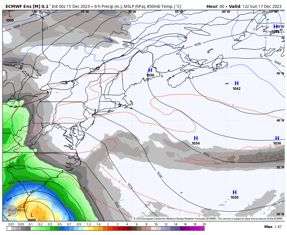 Sunday 7 AM to Tuesday 7 AM - A rough idea on timing here. Strong high pressure to the east is dry as a bone and it appears to stay in the neighborhood long enough to keep the rain away until late day Sunday. There could be some cold air damming involved here, which may bring areas of freezing rain over the interior Sunday night before the surge of mild air arrives overnight into Monday. Light to moderate rain over the north, moderate to heavy rain over south of the mountains and eastward is on tap for the Monday morning commute. A stronger surge of rainfall is good possibility through the day, then becomes lighter heading into Tuesday morning. With blocking in place to the northeast, the upper-level trough is expected to hang around and keep precipitation potential going into Tuesday, and perhaps Wednesday. The mountains could see snow showers, with rain showers possible elsewhere. 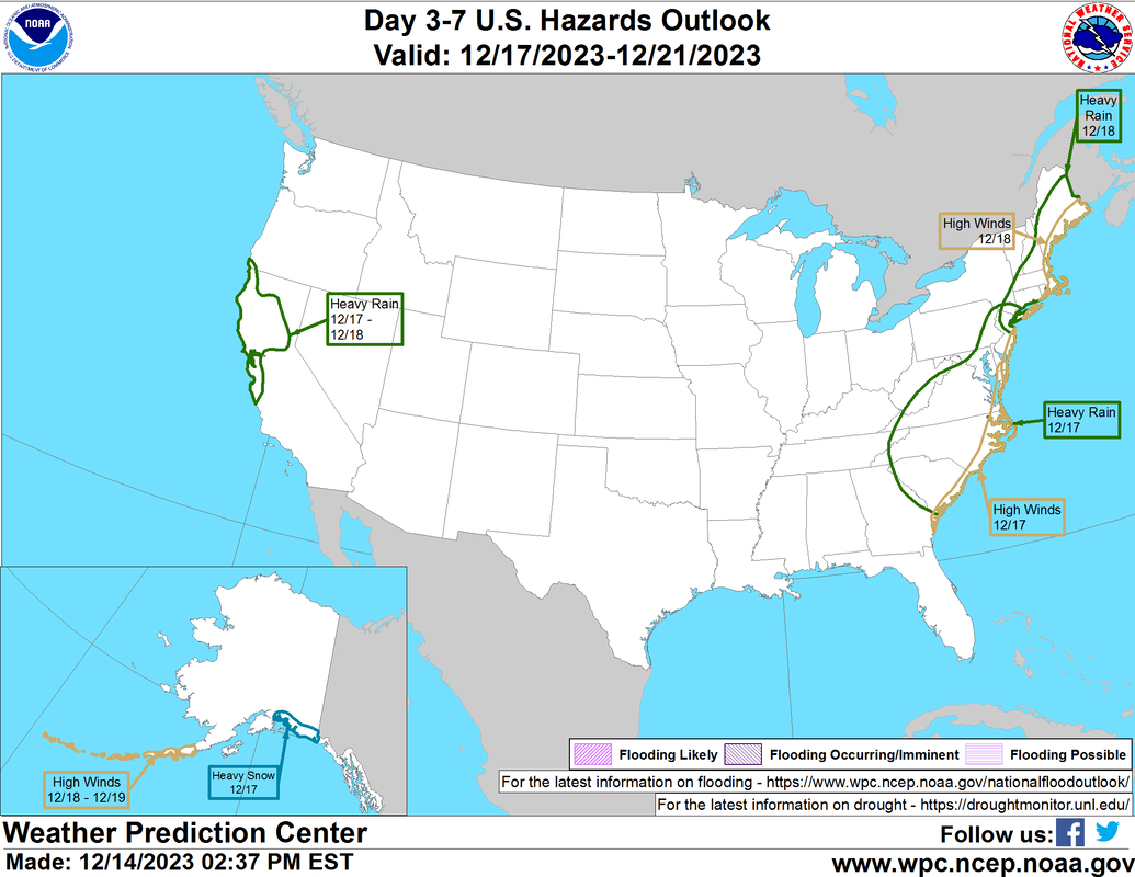 The Weather Prediction Center has the region highlighted for heavy rain concerns over much of the state, as well as wind for the coast. The general idea of 1½-3½" of rainfall that could bring another round of flash flooding in areas appears likely. Given the projected track, wind direction appears out of the south / southeast with coastal areas receiving the brunt of that. A rough idea on speeds appears in the 40-50 mph range for MidCoast areas and 50-60 mph DownEast. The other element in this is the risk of thunderstorms that could bring a vertical wind threat. Unlike the previous storms that were a quick hitters, this may be more of a longer duration event. With the peak winds expected to blow through in the afternoon, that also comes at the time of high tide in the mid-afternoon. With forecast surf in the 13-19' range, the exposed shorelines are likely to get battered again. Thankfully, tides will be off astronomical highs, but the timing does set up the potential for minor coastal flooding, splash-over and beach erosion. While the forecast becomes more refined, it would be wise prepare for power outages and wind damage along the coastal plain and potential for flooding for most areas. Stay tuned. Designed for you, supported by you Thank you to Allspeed Cyclery & Snow in Portland, Downeast Aerial Photography in Rockland, Dutch Elm Golf Club in Arundel, and Sunrise Property Services in Bridgton, for partnering with Pine Tree Weather. Special thanks to all the individuals who financially contribute. I sincerely appreciate your support. Stay updated, stay on alert, and stay safe! - Mike PRINT MEDIA: Feel free to quote and cite my work here for your stories. Please give me the professional courtesy of knowing that you are referencing my material so I can read your final product and acknowledge it on my media and link it on the Who I Am page here on the website. Feel free to send me a message via the Facebook page or Twitter (X) to get my phone number if necessary. Thank you! NOTE: The forecast information depicted on this platform is for general information purposes only for the public and is not designed or intended for commercial use. For those seeking pinpoint weather information for business operations, you should use a private sector source. For information about where to find commercial forecasters to assist your business, please message me and I will be happy to help you. |

Mike Haggett
|


