Pine Tree Weather
  • DISCUSSIONS
  • DONATE
  • WEATHER WALL
  • MAPS
  • RAIN OUTLOOK
  • SEVERE
  • MARINE
  • CPC OUTLOOK
  • Kennebunk
  • MY BIO
  • PTW IN MEDIA
  • OBSERVING WEATHER
  • INTERNSHIPS
  • INTERN ALUMNI
  • DISCUSSIONS
  • DONATE
  • WEATHER WALL
  • MAPS
  • RAIN OUTLOOK
  • SEVERE
  • MARINE
  • CPC OUTLOOK
  • Kennebunk
  • MY BIO
  • PTW IN MEDIA
  • OBSERVING WEATHER
  • INTERNSHIPS
  • INTERN ALUMNI

Friday December 29, 2023

12/29/2023

Comments


Water vapor image tells the story 

Picture
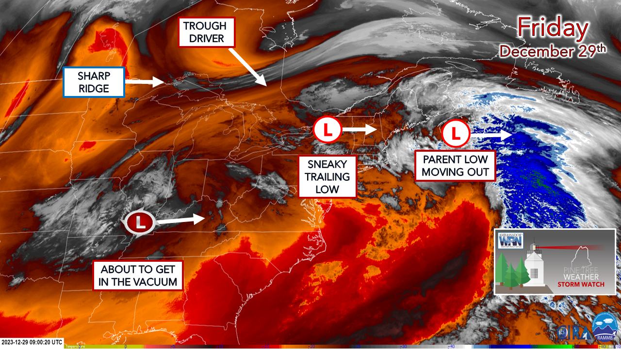
All of the players are in the regional view as of early Friday morning. The parent low  is moving east out to sea, and a sneaky trailing low passes through Friday night into Saturday. The trough driver bringing the cold is racing down from Ontario. The cut-off low that has hung out over the Midwest all week is weakening and is about to be absorbed by the trough. The ridge to the west is like the mother in the minivan who is loading up the kids after soccer practice to take them home and will carry them out of the area Saturday.

All four precipitation food groups through Saturday

Picture
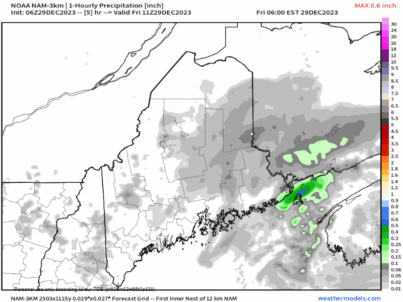
Friday 6 AM to Saturday 9 PM - This is one hour increments of liquid equivalent precipitation used here. The reason I've used this is because precipitation type will vary pending on region, and I don't trust model ideas of what that may appear as given the marginal temperatures in the 30s. Northern areas see snow. Where cold air damming has settled in, those areas see some ice accretion. Where it has not sees rain showers. 

The parent low departs Friday morning and a bit of a lull works in Friday afternoon. As the trailing low slides east, precipitation picks back up Friday night and into Saturday morning. As the cold air works in aloft, the transition from rain and freezing rain flips to snow. Much of the interior sees snow showers or pockets of light snow through the day. A coastal front sets up in the morning, which keeps the shoreline regions wet with snow on the other side of it. How far inland the coastal front goes is always a bit of a coin toss. Those that live within 10-40 miles of the ocean may see a mix of snow and rain pending on what the front decides it wants to handle itself. As the cold front works through Saturday afternoon, areas seeing rain get a few snowflakes as a parting gift when the precipitation wraps up. 

Outside of some mountain upslope snow showers, precipitation ends from west to east Saturday afternoon ending over eastern areas by mid-evening.
Picture
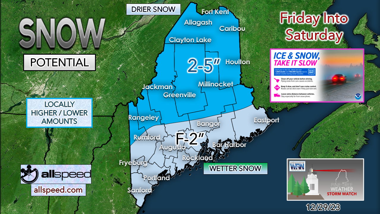
Rule of thumb here is higher elevations have the better chance for snow as the cold air works in. The valleys won't see as much, and where cold air damming hasn't worked in could see lesser amounts, too. With marginal temperatures around the freezing mark and not a whole of of forcing with the trailing low, I don't expect this to be much of an accumulator. Areas around the coastal front may see bursts of moderate snow on the cold side, so be aware of that. 

Given the weak nature of the trailing low, I don't see much of an issue for travel. Untreated areas may be slick in spots, especially on the roads less travelled. The common sense approach of responsible driving to the conditions is the way to go. 

Outlook through Thursday

Picture
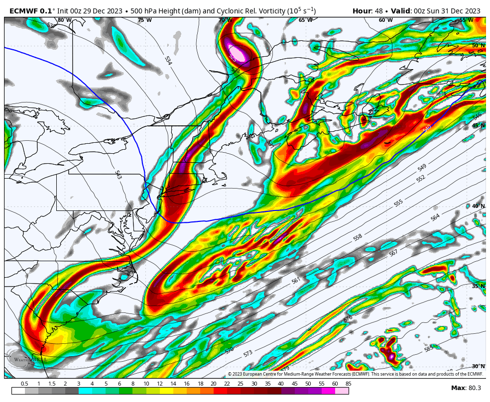
Saturday 7 PM to Thursday 7 PM - The pattern becomes more progressive heading into next week. Shortwaves may bring some clouds in areas with mountain snow showers through New Years Day. An ocean storm misses the region Tuesday, but we'll need to keep an eye out for one Thursday into Friday. That big hook you see at the end of the loop, it might restart winter over the interior, and coastal areas should be on notice. 

Temperatures cool down in the ten day trend, which is an indicator that the chances for snow will increase.
Picture
Picture
Picture
Picture
Picture

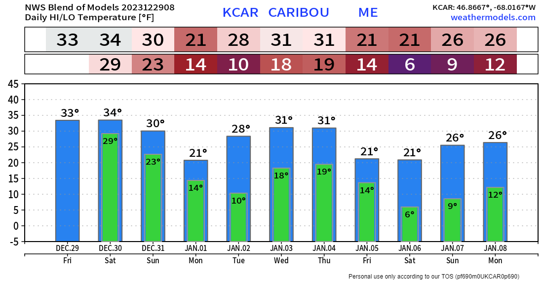
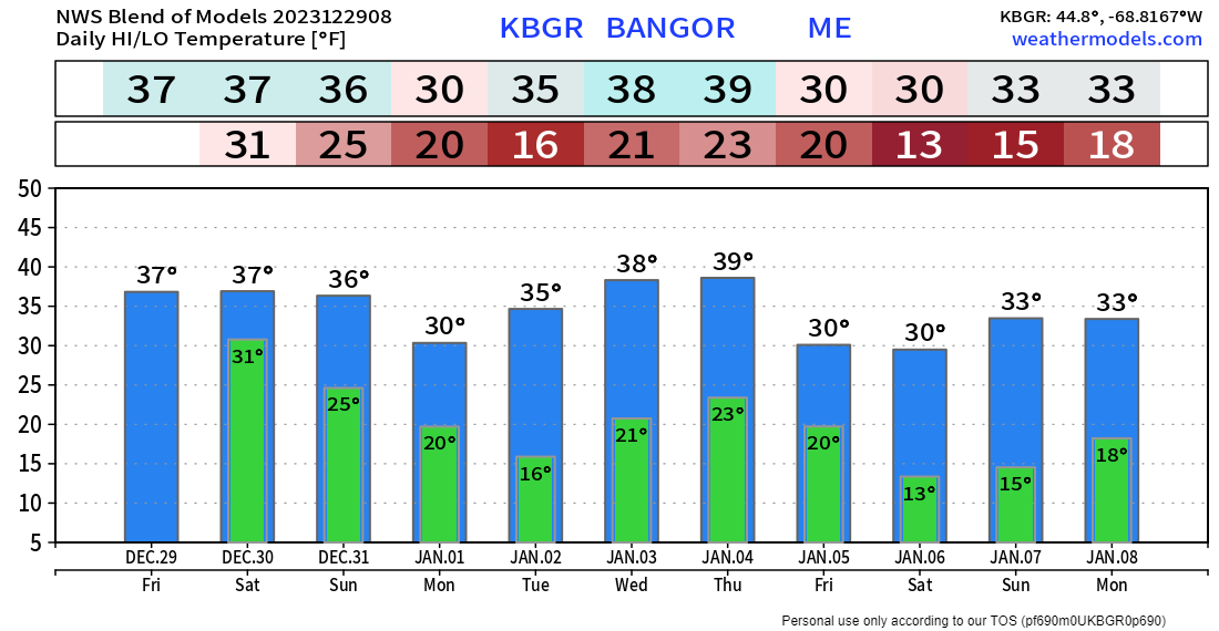
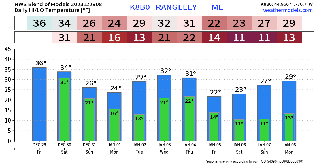
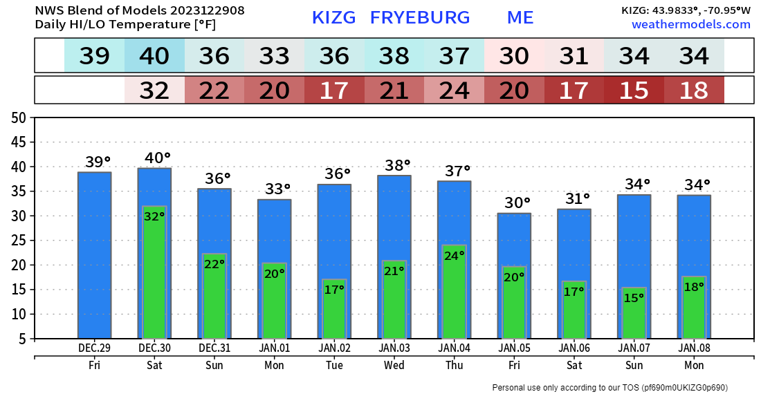
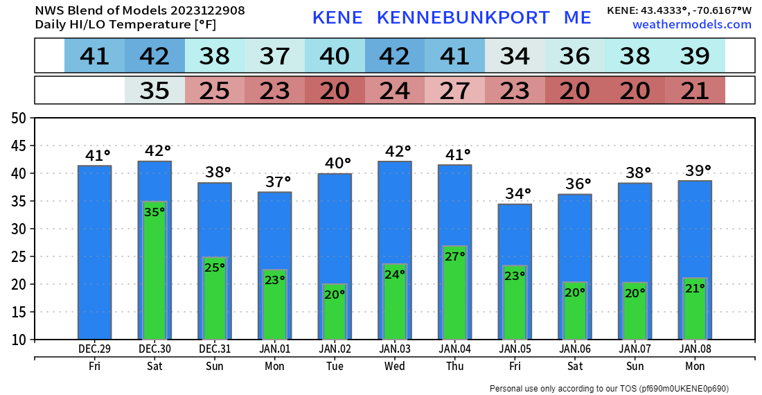
You are reading this as the result of the generosity
​of others before you who believe in the mission

Picture

Thank you to Allspeed Cyclery & Snow in Portland, Downeast Aerial Photography in Rockland, Dutch Elm Golf Club in Arundel,
and Sunrise Property Services in Bridgton, for partnering with Pine Tree Weather.

Special thanks to all the individuals who financially contribute.
​I sincerely appreciate your support. 


Stay updated, stay on alert, and stay safe!

- Mike

PRINT MEDIA: Feel free to quote and cite my work here for your stories. Please give me the professional courtesy of knowing that you are referencing my material so I can read your final product and acknowledge it on my media and link it on the Who I Am page here on the website. Feel free to send me a message via the Facebook page or Twitter (X) to get my phone number if necessary. Thank you! ​

​NOTE: The forecast information depicted on this platform is for general information purposes only for the public and is not designed or intended for commercial use. For those seeking pinpoint weather information for business operations, you should use a private sector source. For information about where to find commercial forecasters to assist your business, please message me and I will be happy to help you.

Comments
    Picture

    Mike Haggett
    Kennebunk, ME

    Weather-Ready Nation
    Ambassador

    Certified Weather
    Forecaster
    Penn State '21

    American Meteorological Society

    National Weather Association
    ​
    ​SKYWARN-CWOP

    Matthew 19:26


    DONATE

    Picture
    Picture
    Picture
    Picture
    Picture

    Picture

    Picture

    Picture

    Picture

    Picture

    Picture

    Picture

    Picture

    Picture

    Picture

    Picture

    Picture


    Archives

    April 2025
    March 2025
    February 2025
    January 2025
    December 2024
    November 2024
    October 2024
    September 2024
    August 2024
    July 2024
    June 2024
    May 2024
    April 2024
    March 2024
    February 2024
    January 2024
    December 2023
    November 2023
    October 2023
    September 2023
    August 2023
    July 2023
    June 2023
    May 2023
    April 2023
    March 2023
    February 2023
    January 2023
    December 2022
    November 2022
    October 2022
    September 2022
    August 2022
    July 2022
    June 2022
    May 2022
    April 2022
    March 2022
    February 2022
    January 2022
    December 2021
    November 2021
    October 2021
    September 2021
    August 2021
    July 2021
    June 2021
    May 2021
    April 2021
    March 2021
    February 2021
    January 2021
    December 2020
    November 2020
    October 2020
    September 2020
    August 2020
    July 2020
    June 2020
    May 2020
    April 2020
    March 2020
    February 2020
    January 2020
    December 2019
    November 2019
    October 2019
    September 2019
    August 2019
    July 2019
    June 2019
    May 2019
    April 2019
    March 2019
    February 2019
    January 2019
    December 2018
    November 2018
    October 2018
    September 2018
    August 2018
    July 2018
    June 2018
    May 2018
    April 2018
    March 2018
    February 2018
    January 2018
    December 2017
    November 2017
    October 2017

Proudly powered by Weebly