Pine Tree Weather
  • DISCUSSIONS
  • Substack
  • WEATHER WALL
  • MARINE
  • CPC OUTLOOK
  • Kennebunk
  • INTERNSHIPS
  • MY BIO
  • PTW IN MEDIA
  • INTERN ALUMNI
  • DISCUSSIONS
  • Substack
  • WEATHER WALL
  • MARINE
  • CPC OUTLOOK
  • Kennebunk
  • INTERNSHIPS
  • MY BIO
  • PTW IN MEDIA
  • INTERN ALUMNI

Friday December 8, 2023

12/8/2023

Comments

 
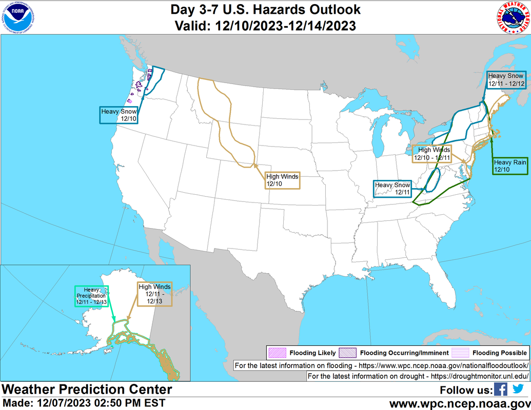
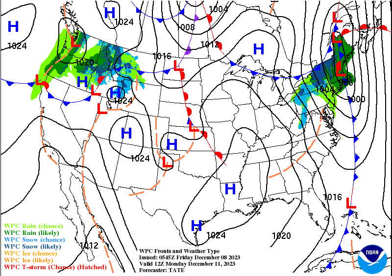
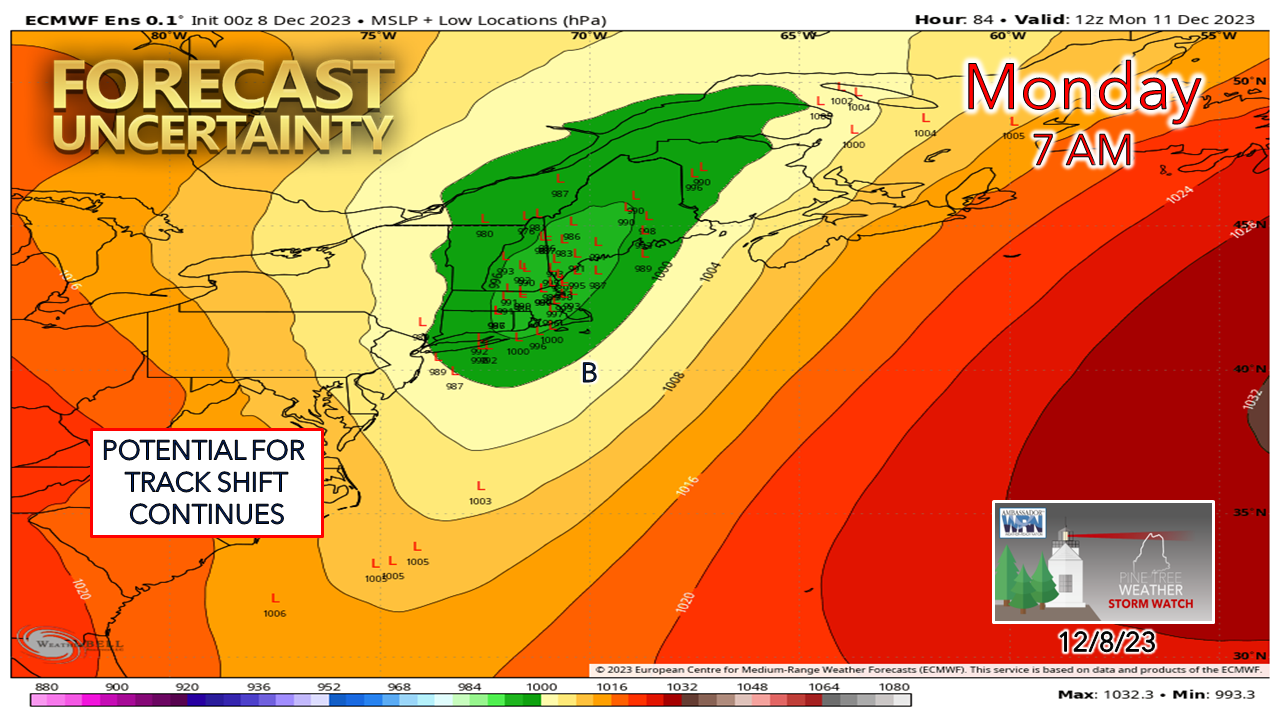
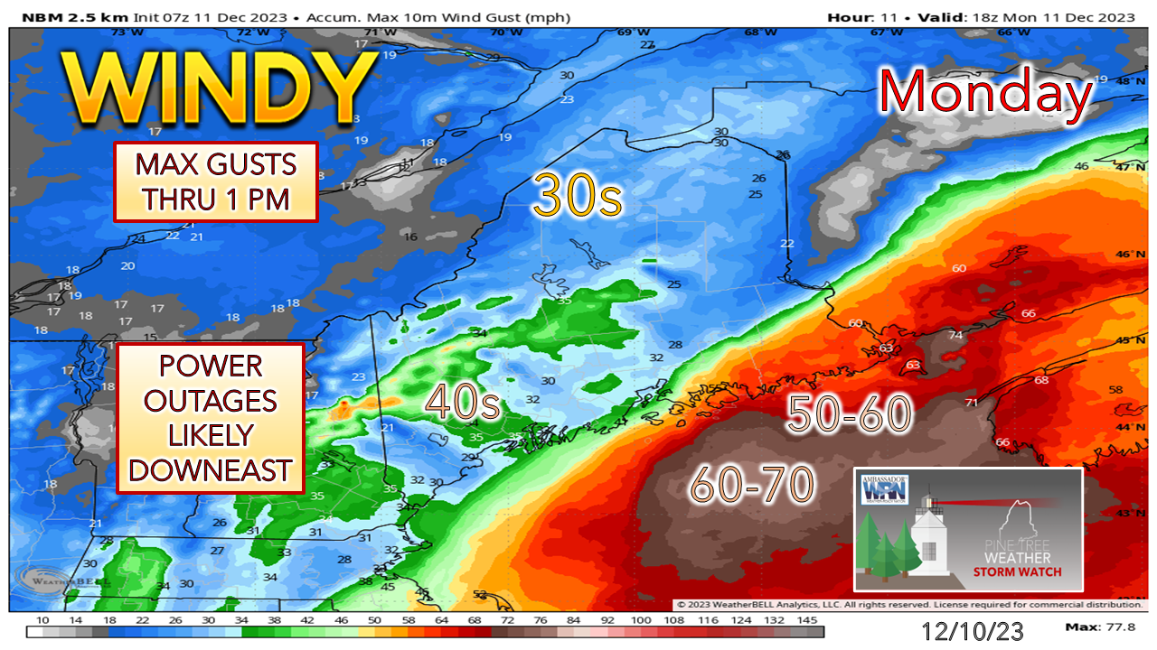
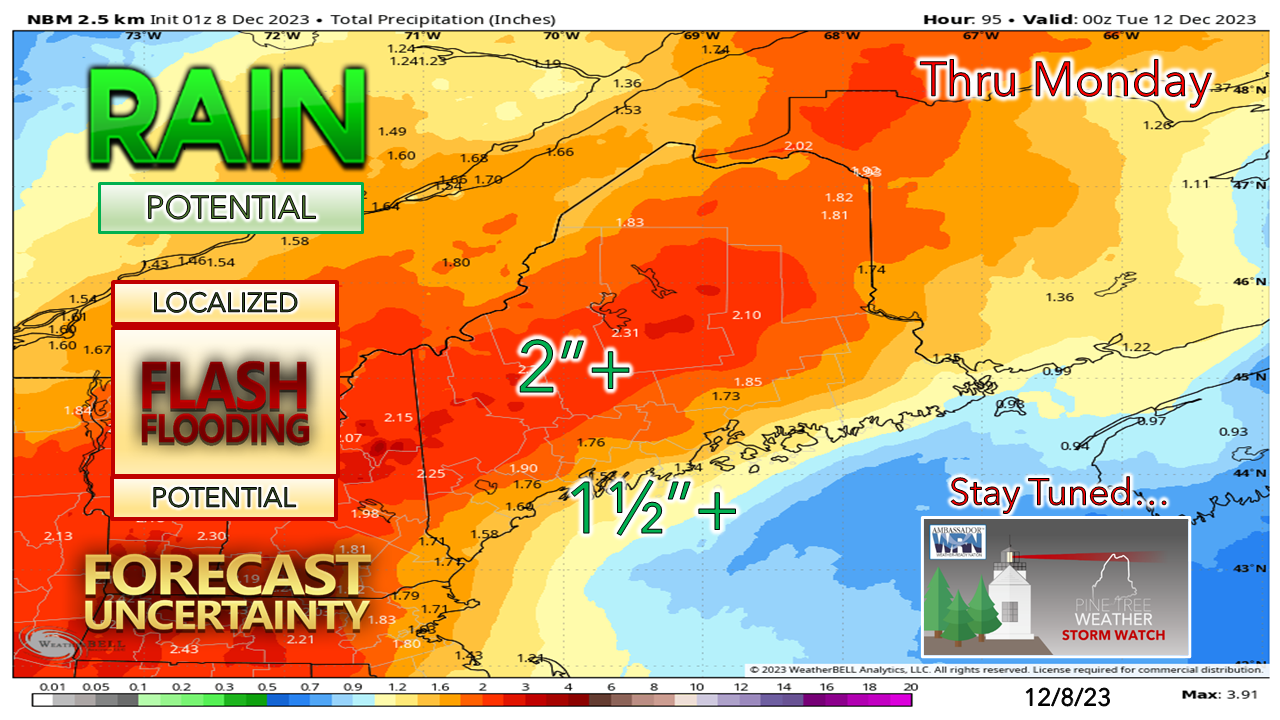
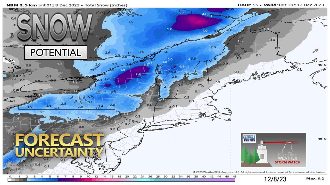
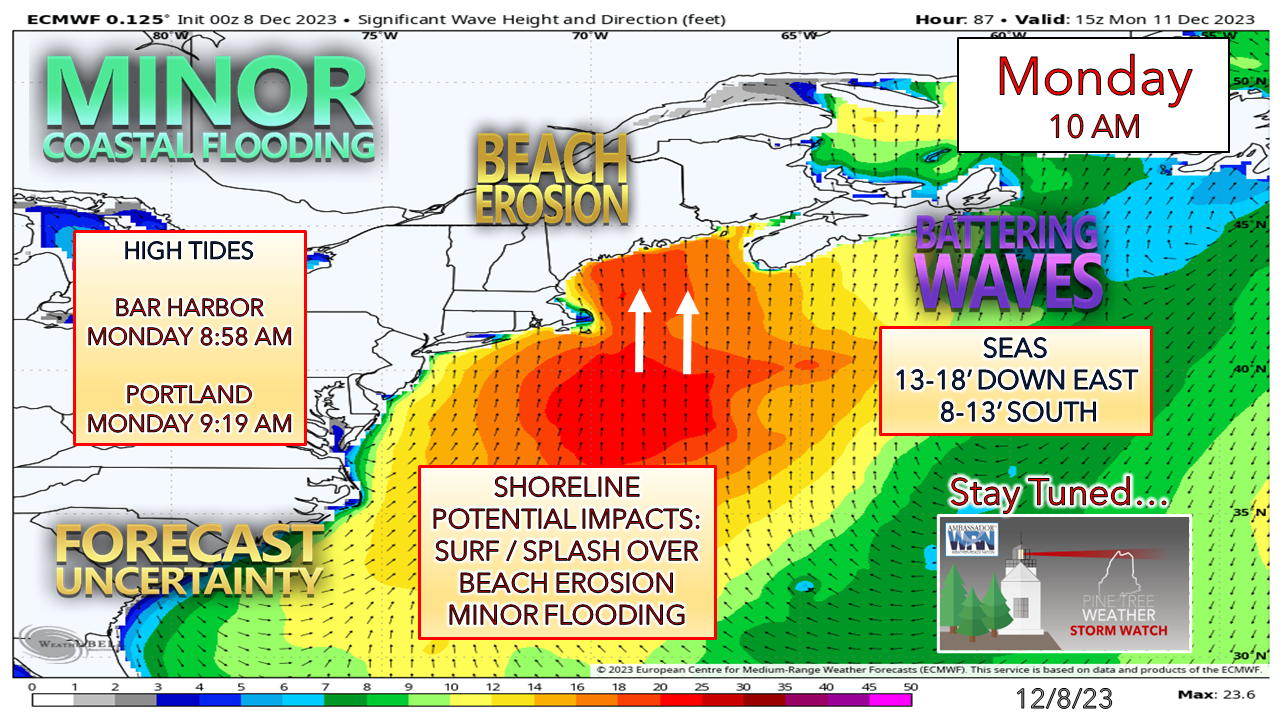
Just a heads up that I will be in the City of Ships of Bath for the next couple of days to call a basketball tournament at the Hyde School. I will have my laptop, and I will update from there Saturday morning. How in-depth of an update is to be determined. Knowing that, this update should provide a pretty good idea of what to expect Sunday into Monday. 

Wind, rain, and snow knocking on the doorstep
​to start the week

Picture
As time moves closer to the storm, the more interesting it gets. Where Vermont was looking at a washout maybe looking at a decent snowfall. The axis of rain has shifted east over Maine. Wind continues to be the greatest concern. The good news is that it appears to be a quick hitter, but it is expected to bring a punch and leave a mess in its wake. 

Back to the future

One thing experienced forecasters look at when it comes to figuring out storm potential are analogs from previous events. Occasionally they line up in range. This is a great tool to look back on to help guide prospective outcomes.

This storm from Thanksgiving Day in 2013 is near what is expected with this one. A deep trough moving in south of Florida driving up a juicy moisture hose (atmospheric river) with a lead low pressure system and disturbances riding along the frontal boundary. ​
Picture
The storm was a corker. From what information I could dig up from various sources, roughly 1½-3½" of rain fell, along with wind gusts between 40-70 mph (Mount Washington peaking at 102 mph). Newspaper reports provided pictures of flooding, wind damage, and reports of power outages that ruined some holiday dinners and had municipal crews clearing storm drains where streets turned into rivers. 
Picture
This is the forecast from the Weather Prediction Center for Monday. 

​Buckle up. Here we go again. 

Still some wiggle room which could alter the outcome

Picture
Where once the ideas were tracking along the St. Lawrence River, it has shifted more of a south to north track that drives the parent low through the heart of the state up into eastern Quebec.

The concern with track on the one is the cold air to the northwest that comes in behind the parent low. A more eastward shift brings the idea of snow becoming more of factor. With the neighboring Kingdom of Vermont potentially seeing a winter storm watch, the cold is a player here. 
Picture
With the surge of moisture being driven in by a a strong low-level jet at around 2,000 feet aloft that could peak out at 90-100 knots, along with the risk of heavy rain makes the wind a double edged sword. There is both the horizontal and vertical downdraft threats to consider here. A wind advisory is a given for the coast. A high wind watch / warning is likely to come for MidCoast and DownEast areas. 

The wind is expected to gradually pick up Sunday afternoon with the highest gusts starting around midnight Monday, ending from west to east between 8 AM to around noon. 

A northwest wind comes in on the backside and will continue through Tuesday and diminish Wednesday. 

Secure your holiday displays. 
Picture
The ground is frozen at this point over 95% of the region. The rain has no place to go but into brooks, streams, small rivers, roads, and basements. The Weather Prediction Center has the entire state under a marginal risk of flash flooding. There will likely be snow melt over the coastal interior on up into the foothills which may flood some of the smaller rivers. The snowpack in the mountains have the capacity to absorb quite a bit. It's a timing game of the arrival of the cold that determines when the damage ends. 

Don't be surprised if there is some thunder involved here. With deep cold close, it could be loud. 
Picture
The snow ideas have shifted east as the ideas on track have gone that way. I don't take a whole lot of stock in this outcome anything more than a bit of backside paste as the storm heads for Labrador. This could change. 

The one thing ALL AREAS need to be concerned about is falling temperatures. It's expected that there will be a nocturnal high around midnight Monday, and with the frontal passage, temperatures drop below freezing in the mountains in the afternoon, over the foothills on up into northern areas by mid-evening, and the coast by Tuesday morning as the northwest wind rushes the cold in.

Can you say, "skating rink"? Black ice city. Sharpen your wheel studs and have your creepers on your boots. You may need them.
Picture
The shorelines are likely to get trashed. That high tide Monday morning that is expected to run about 1-1½' above due to astronomical levels, add the potential for storm surge, and the wave action. I am going with the idea of minor coastal flooding for now, but that could be elevated pending on how this plays out. 

Stay tuned.

Prepare now. 

Please make my 2 AM wake up calls worth it
​and help me pay the bills

Picture

​Thank you to Allspeed Cyclery & Snow in Portland, Downeast Aerial Photography in Rockland, Dutch Elm Golf Club in Arundel,
and Sunrise Property Services in Bridgton, for partnering with Pine Tree Weather.

Special thanks to all the individuals who financially contribute.
​I sincerely appreciate your support. 


Stay updated, stay on alert, and stay safe!

- Mike

PRINT MEDIA: Feel free to quote and cite my work here for your stories. Please give me the professional courtesy of knowing that you are referencing my material so I can read your final product and acknowledge it on my media and link it on the Who I Am page here on the website. Feel free to send me a message via the Facebook page or Twitter (X) to get my phone number if necessary. Thank you!  ​

​NOTE: The forecast information depicted on this platform is for general information purposes only for the public and is not designed or intended for commercial use. For those seeking pinpoint weather information for business operations, you should use a private sector source. For information about where to find commercial forecasters to assist your business, please message me and I will be happy to help you.

Comments
    Picture

    Mike Haggett
    Kennebunk, ME

    Weather-Ready Nation
    Ambassador

    Certified Weather
    Forecaster
    Penn State '21

    American Meteorological Society

    National Weather Association
    ​
    ​SKYWARN-CWOP

    Matthew 19:26


    DONATE

    Picture
    Picture
    Picture
    Picture
    Picture
    Picture

    Picture

    Picture

    Picture

    Picture

    Picture

    Picture

    Picture

    Picture

    Picture

    Picture

    Picture

    Picture


    Archives

    January 2026
    December 2025
    November 2025
    October 2025
    September 2025
    August 2025
    July 2025
    June 2025
    May 2025
    April 2025
    March 2025
    February 2025
    January 2025
    December 2024
    November 2024
    October 2024
    September 2024
    August 2024
    July 2024
    June 2024
    May 2024
    April 2024
    March 2024
    February 2024
    January 2024
    December 2023
    November 2023
    October 2023
    September 2023
    August 2023
    July 2023
    June 2023
    May 2023
    April 2023
    March 2023
    February 2023
    January 2023
    December 2022
    November 2022
    October 2022
    September 2022
    August 2022
    July 2022
    June 2022
    May 2022
    April 2022
    March 2022
    February 2022
    January 2022
    December 2021
    November 2021
    October 2021
    September 2021
    August 2021
    July 2021
    June 2021
    May 2021
    April 2021
    March 2021
    February 2021
    January 2021
    December 2020
    November 2020
    October 2020
    September 2020
    August 2020
    July 2020
    June 2020
    May 2020
    April 2020
    March 2020
    February 2020
    January 2020
    December 2019
    November 2019
    October 2019
    September 2019
    August 2019
    July 2019
    June 2019
    May 2019
    April 2019
    March 2019
    February 2019
    January 2019
    December 2018
    November 2018
    October 2018
    September 2018
    August 2018
    July 2018
    June 2018
    May 2018
    April 2018
    March 2018
    February 2018
    January 2018
    December 2017
    November 2017
    October 2017

Proudly powered by Weebly