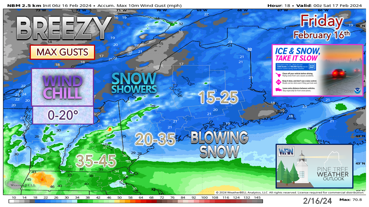
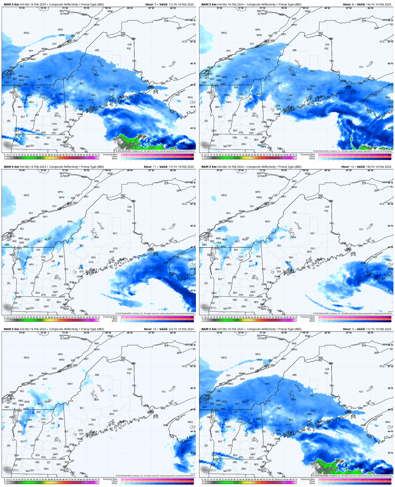
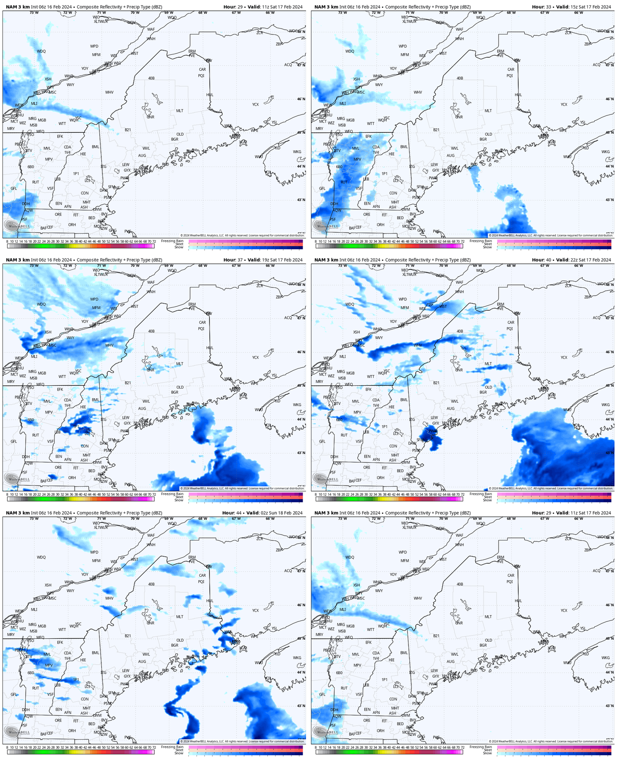
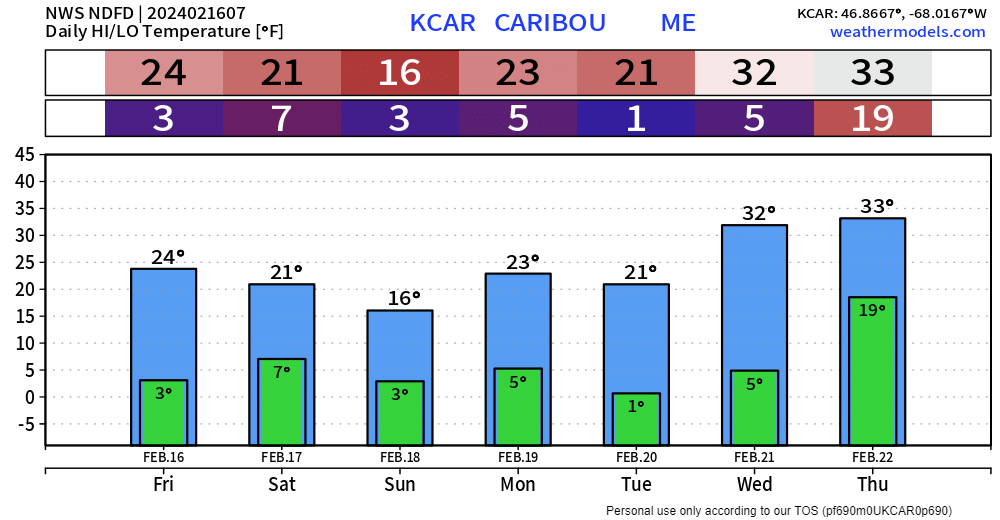
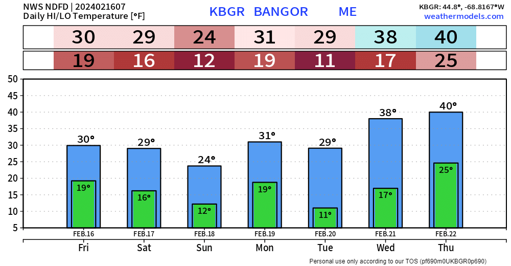
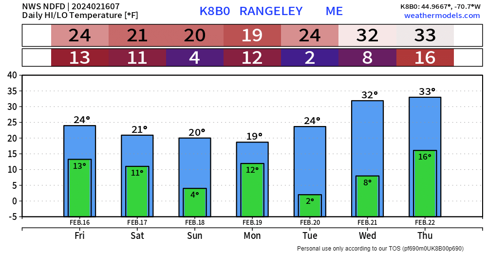
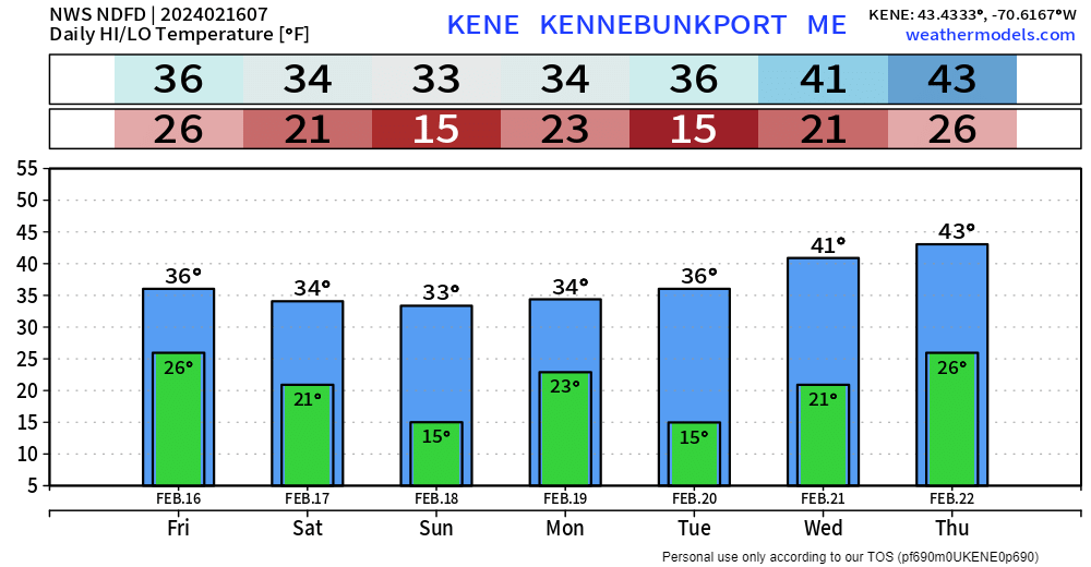
Snow ends and the wind picks upA wind advisory is in effect for southern New Hampshire through 1 PM as a low level jet streak passes through. Some of the stronger gusts may impact the southern border towns with gusts upwards of 45 mph. The mountains sees a stiff breeze, and may cause wind holds on the lifts. The wind speeds settle down in the afternoon as the storm heads east with a weak area of high pressure arriving Friday evening. For areas that picked up some of the fluff overnight, it may blow around, especially along the coast where accumulations were a bit higher east of Portland and MidCoast areas. This will be a day to bundle up as wind chill values range from around 0° in the mountains to around 20° for the coast. Friday 6 AM (11z) to 7 PM (00z Saturday) - Snow tapers off over the much of the region in the morning. There could be a few lingering snow showers over the MidCoast region and the mountains through the afternoon. Areas that are under a winter weather advisory should expect that to expire on time. A few snow showers around for SaturdaySaturday 6 AM (11z) to Sunday Midnight (05z) - A storm passes by well south of the region, but may interact with upper level energy associated with the trough moving in from the northwest. This will kick up some snow showers primarily in the mountains, with some isolated activity elsewhere through the afternoon into the evening. Little to no accumulation is expected. The wind picks up again in the afternoon as the storm to the south departs and the wave passes through. Wind gusts in the teens and 20s continue overnight and into Sunday morning. Outlook for the week aheadFriday 7 AM (12z) to Next Friday (00z Saturday) - Overall a seasonably cool and dry pattern is expected through midweek. Upper level troughing spins waves through which may bring some charity flakes to the mountains and north on Sunday, and then again on Tuesday as a ridge moves in. That ridge brings temperatures up as we head into the latter part of the week. A developing deep trough is the key feature to watch for a potential storm next Friday. Website upgrades and tweaks continuePlease take the time to check out different pages, see what is available. I continue to improve the data available on this site to give you the information you need at anytime across the state. I am not done with the upgrades yet as I am always exploring options to improve. Thank you to Allspeed Cyclery & Snow in Portland, Downeast Aerial Photography in Rockland, Dutch Elm Golf Club in Arundel, and Sunrise Property Services in Bridgton, for partnering with Pine Tree Weather. Special thanks to all the individuals and businesses who financially contribute. I sincerely appreciate your support. Always have MULTIPLE ways to receive weather alerts. Stay updated, stay on alert, and stay safe! - Mike PRINT MEDIA: Feel free to quote and cite my work here for your stories. Please give me the professional courtesy of knowing that you are referencing my material so I can read your final product and acknowledge it on my media and link it on the PTW IN MEDIA page here on the website. Feel free to send me a message via the Facebook page or Twitter (X) to get my phone number if necessary. Thank you! NOTE: The forecast information depicted on this platform is for general information purposes only for the public and is not designed or intended for commercial use. For those seeking pinpoint weather information for business operations, you should use a private sector source. For information about where to find commercial forecasters to assist your business, please message me and I will be happy to help you. |
Mike Haggett
|

