Pine Tree Weather
  • DISCUSSIONS
  • DONATE
  • MAPS
  • NWS BRIEFINGS
  • SATRAD
  • MARINE
  • SNOW / ICE OUTLOOK
  • RAIN OUTLOOK
  • CPC OUTLOOK
  • Kennebunk
  • OBSERVING WEATHER
  • Who We Are
  • My Photography
  • DISCUSSIONS
  • DONATE
  • MAPS
  • NWS BRIEFINGS
  • SATRAD
  • MARINE
  • SNOW / ICE OUTLOOK
  • RAIN OUTLOOK
  • CPC OUTLOOK
  • Kennebunk
  • OBSERVING WEATHER
  • Who We Are
  • My Photography

Frost alert for Tuesday AM; Dry times continue

9/14/2020

Comments

 
Picture
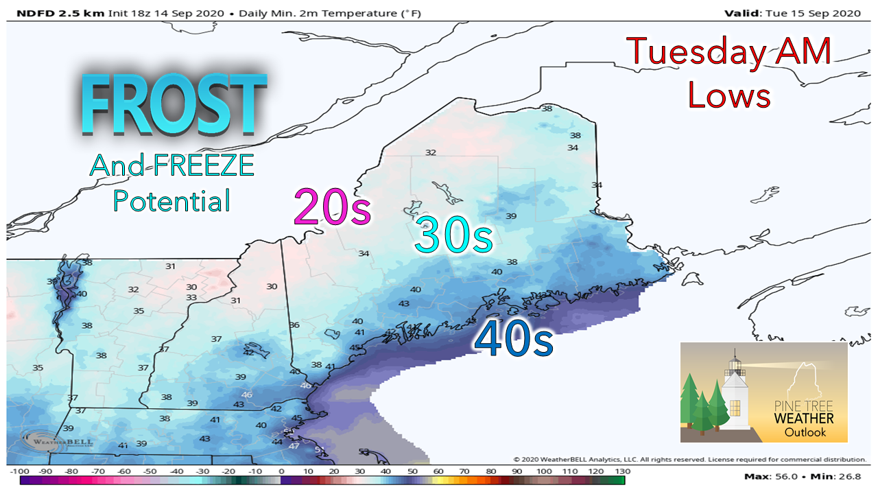
9-14-20 #MEwx MONDAY Update - FROST ALERT for Tuesday AM; Dry times continue.

For those who the took time to read my post on the website Sunday, this is no huge surprise to you. I mentioned concerns about potential frost for areas near the coast. I am going to stick to my thoughts on that.

If you look up into the sky, you will see the haze from smoke. Smoke has a way of fooling models. There is enough of a haze around where I expect that it will be colder in areas than what is predicted. With a clear (hazy) sky and little to no wind, the frost threat increases. Smoke does not act like clouds. The particles allows for long wave radiation from the day to escape, allowing for more cooling potential.

Many of you are gardeners, whether you have vegetables or flowers going. My suggestion is to cover them up, unless you can smell the ocean from your doorstep. It's better to be safe than sorry in this situation.

Also be aware that this could happen again Friday night into Saturday, so keep the blankets on the ready just in case.

Other concerns... the region will stay dry from the looks through the weekend. Remnants of Sally do not appear to make it up here. We'll get a moisture starved frontal boundary that appears to pass through on Thursday. Northern areas appear to have the best chance for rainfall, as scant as it looks for now. When the next rain maker comes is anyone's guess at this point.

The lack of rainfall and low dew points means the fire threat will continue. Wind will dictate how much of a problem that will be. Wednesday, Thursday and Saturday we could see some elevated speeds as frontal boundaries pass through. Use extreme caution with anything flammable, and always check with your local FD / forest ranger / park ranger before burning.

Thanks as always for your support!
​
- Mike
Comments
    Picture

    Mike Haggett
    Kennebunk, ME

    Certified Weather
    Forecaster
    Penn State '21

    American Meteorological Society

    National Weather Association

    Weather-Ready Nation 
    Ambassador
    ​
    ​SKYWARN-CWOP

    Matthew 19:26


    Support
    Pine Tree Weather

    DONATE

    Picture

    Picture

    Picture

    Picture

    Picture

    Picture

    Picture

    Picture

    Picture

    Picture

    Archives

    January 2023
    December 2022
    November 2022
    October 2022
    September 2022
    August 2022
    July 2022
    June 2022
    May 2022
    April 2022
    March 2022
    February 2022
    January 2022
    December 2021
    November 2021
    October 2021
    September 2021
    August 2021
    July 2021
    June 2021
    May 2021
    April 2021
    March 2021
    February 2021
    January 2021
    December 2020
    November 2020
    October 2020
    September 2020
    August 2020
    July 2020
    June 2020
    May 2020
    April 2020
    March 2020
    February 2020
    January 2020
    December 2019
    November 2019
    October 2019
    September 2019
    August 2019
    July 2019
    June 2019
    May 2019
    April 2019
    March 2019
    February 2019
    January 2019
    December 2018
    November 2018
    October 2018
    September 2018
    August 2018
    July 2018
    June 2018
    May 2018
    April 2018
    March 2018
    February 2018
    January 2018
    December 2017
    November 2017
    October 2017

    RSS Feed

Proudly powered by Weebly