
|
Before I get into the forecast, I have a few things to pass along. First, the format that I have been going with for a while now is going to change. My run of 2 - 3 AM wake up calls for months in this one-person operation. has taken its toll on me. Working a demanding day job along with little time with family and a bizarre sleep pattern is forcing me to change things around. While I love providing in-depth discussions, those will be saved for more complicated and impactful events. My updates may become a bit erratic as to when they happen. The goal here is for at least four updates per week depending on how active the pattern is. My focus will be primarily on impact weather, in the short term (24-72 hours), and will pass along anything of concern up to 7 days out. I sincerely appreciate your readership, encouragement, financial support, and sharing with others what I do here. Frost advisory for interior areas Saturday morning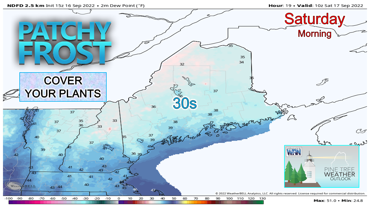 High pressure takes over aloft, winds calm, and a cloudless sky sets up radiational cooling for tonight. Dew points (shown above) fall into the 30s for most areas away from the shorelines. While the general idea is for the chance of patchy frost developing for the well protected valleys away from the coast, I'll up the ante a bit and say watch out for any area where you can't smell sea salt from your front door. I know many of you have put your souls into your gardens while dealing with the drought for most of the summer. Protect what you can as a precaution. Isolated showers Saturday, showers and storms Sunday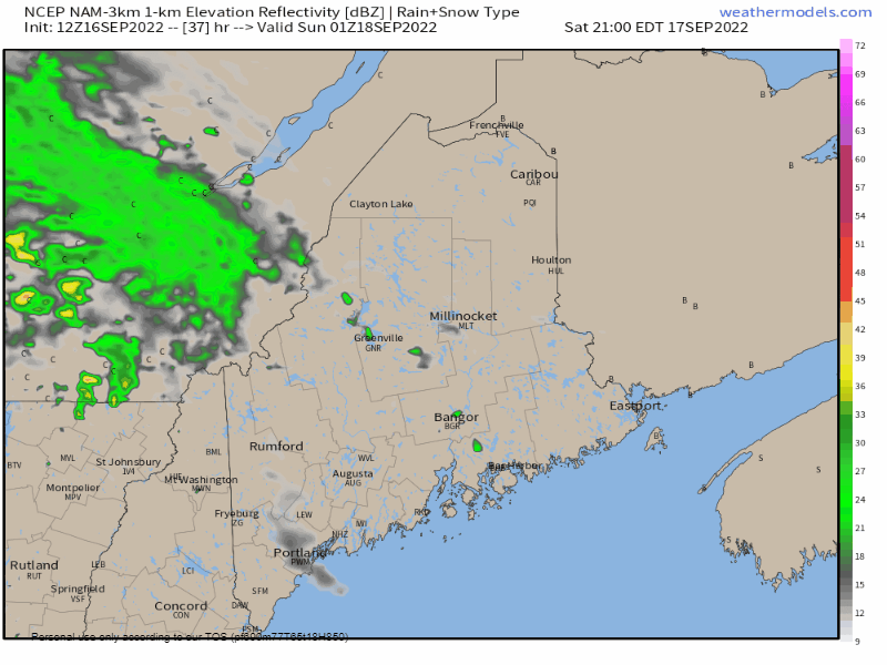 Saturday 9 PM to Sunday 8 PM - The battle line between a ridge advancing from the west and a backdoor cold front dropping down from eastern Quebec sets up over Maine. The western mountains and north may see an isolated shower Saturday afternoon. As the baroclinic leaf from the ridge works up against the descending trough, showers become more numerous over the north, west, and east overnight into Sunday morning. Dew points appear to rise to muggy levels (60-65°) over the south during the day on Sunday. As the backdoor cold front sags south, this sets up the potential for showers and thunderstorms for southwestern areas in the afternoon. How strong the storms could be will depend on the available sun. There could be at least a 20° for high temperatures between the far north (upper 50s) and the far south (low 80s). The front continues south into Southern New England Sunday night and then stalls out. Rain is expected to stay in the forecast through Tuesday for the west and south, and through Wednesday for the north and east. Potential for a soaking rain through Tuesday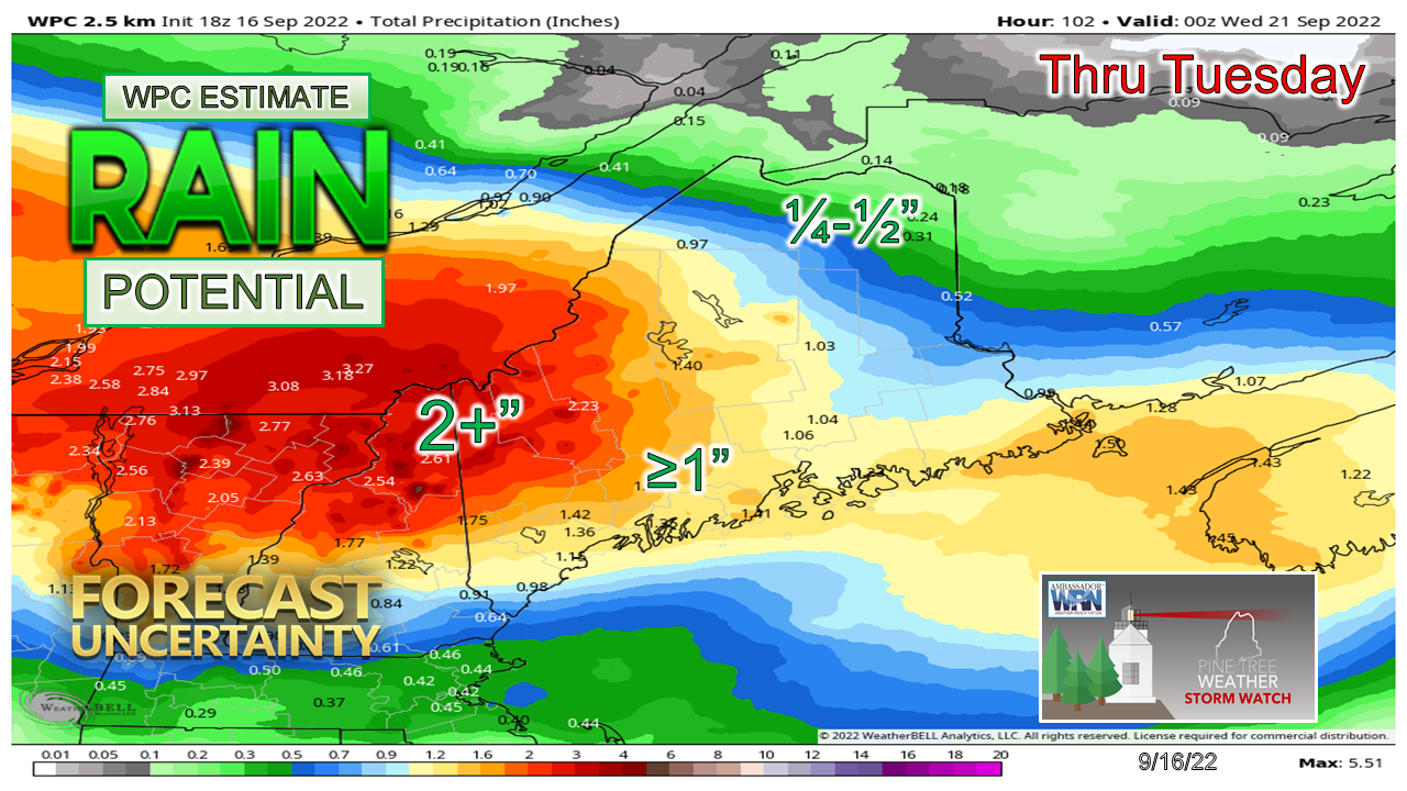 This is a strictly a potential idea at this point dependent on where the front stalls out and when low pressure develops in the Gulf of Maine Monday night. Regardless, many areas could see 1"+ and the mountains could do better than that. The far north gets some rain on Sunday, then has a chance to get a bit more on Wednesday as the low moves into the Canadian Maritimes. Thank you for supporting this community-based weather information source which operates by financial contributions from people like you. Stay updated, stay on alert, and stay safe! - Mike NOTE: The forecast information depicted on this platform is for general information purposes only for the public and is not designed or intended for commercial use. For those seeking pinpoint weather information for business operations, you should use a private sector source. For information about where to find commercial forecasters to assist your business, please message me and I will be happy to help you.
|

Mike Haggett
|


