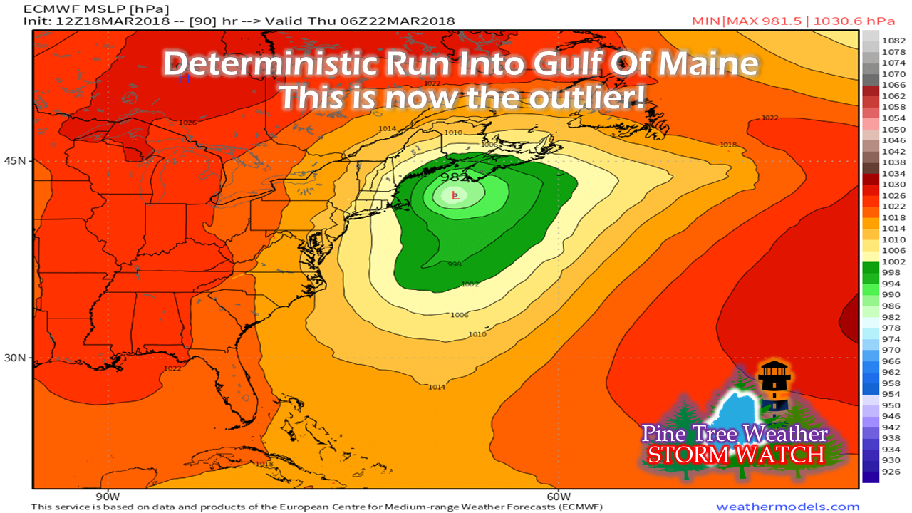
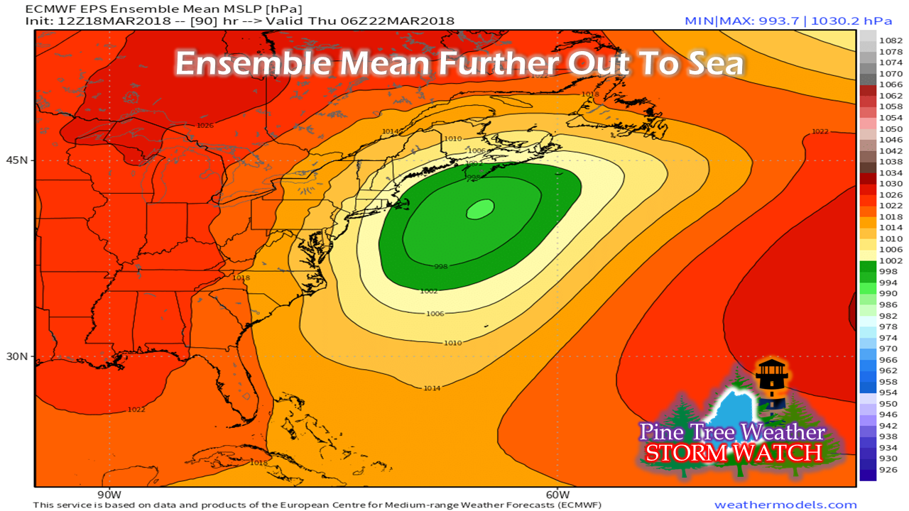
Pine Tree Weather
  • DISCUSSIONS
  • DONATE
  • MAPS
  • NWS BRIEFINGS
  • SATRAD
  • MARINE
  • SNOW / ICE OUTLOOK
  • RAIN OUTLOOK
  • CPC OUTLOOK
  • Kennebunk
  • OBSERVING WEATHER
  • Who We Are
  • My Photography
  • DISCUSSIONS
  • DONATE
  • MAPS
  • NWS BRIEFINGS
  • SATRAD
  • MARINE
  • SNOW / ICE OUTLOOK
  • RAIN OUTLOOK
  • CPC OUTLOOK
  • Kennebunk
  • OBSERVING WEATHER
  • Who We Are
  • My Photography

Guidance still playing games with potential storm Thursday

3/18/2018

Comments


The spring model circus continues

Here's your voice of rationality about late week storm potential. Beware of the hype! As I told you the other day on this very website, models are showing signs of spring by their erratic behavior. As I mentioned on Facebook Sunday morning, the Canadian GGEM model was showing hints that a trailing low could end up in the Gulf of Maine and bring a solid snow event. Now that today's morning model suites have all come in, now it is the European deterministic model that has the idea. 

So now some may say "Well the Euro is the most reliable model and we need to think we're going to get nailed..." 

​Just relax. 

The difference between the European
​deterministic and ensembles 

Picture
The European deterministic run is now the sole outlier in regards to this event.  Yes, it is true that is it brings the storm into the Gulf of Maine. But before you go out and grab bread, milk, and think the kids will be in school until the Fourth of July due to all the snow days, you may want to look at this...
Picture
Since operational and deterministic model ideas spread like wildfire on social media, I thought it would be important to show you the rest of the story. Taking out the deterministic bias of all 51 ensemble members and giving each an equal say in output, the track is further east. With the further east track southeast of Nova Scotia, this would mean less of an impact.

So what about possible snow?

Let's take a look at the European ensemble mean snowfall potential from both the 00z and 12z runs from Sunday:
Picture
As I have been saying for the past couple of days, I have mentioned the MidCoast and DownEast areas have been my concern for snow with this trailing low, and that the coastal plain as a whole could see some snow out of this. The European model idea has been consistent with that idea. This chart above is that from the 00z (8 PM Saturday) overnight model run.

The ensemble idea did shift westward a bit on the 12z (8 AM Sunday) morning run...
Picture
All in all, it's a manageable amount of snow to deal with. Again, it's the MidCoast and DownEast areas that could get the higher amounts. 

In this time of model volatility, it is always the safer bet to look at ensemble ideas like this rather than to purely rely on deterministic or operational models. More times than not, they are wrong this far out, and especially in seasonal change.

NOTE: This is not the final answer here. Tomorrow's runs will help eliminate some of the bias and feedback noise to help iron out the forecast.  This is purely for discussion purposes and to present possibilities.

For the newcomers...

For those regulars who have followed this page for awhile, you'll have to pardon me here as I educate some of the newcomers... be very careful where you get your weather information from. If they aren't showing you or telling you what the possible options are, you should find another source. Model volatility due to the change of seasons is increasing due to spring's astronomical approach on Tuesday. With many folks on edge after three NorEasters in the past two weeks, there are people who will prey on you and will spread ideas that are driven for shares and attention. I don't work that way. ​​ 

Integrity in forecasting is always number one with me.

Beware of the hype!

​Stay tuned.

- Mike

Follow on Twitter

Follow on Facebook

Comments
    Picture

    Mike Haggett
    Kennebunk, ME

    Certified Weather
    Forecaster
    Penn State '21

    American Meteorological Society

    National Weather Association

    Weather-Ready Nation 
    Ambassador
    ​
    ​SKYWARN-CWOP

    Matthew 19:26


    Support
    Pine Tree Weather

    DONATE

    Picture

    Picture

    Picture

    Picture

    Picture

    Picture

    Picture

    Picture

    Picture

    Picture

    Archives

    January 2023
    December 2022
    November 2022
    October 2022
    September 2022
    August 2022
    July 2022
    June 2022
    May 2022
    April 2022
    March 2022
    February 2022
    January 2022
    December 2021
    November 2021
    October 2021
    September 2021
    August 2021
    July 2021
    June 2021
    May 2021
    April 2021
    March 2021
    February 2021
    January 2021
    December 2020
    November 2020
    October 2020
    September 2020
    August 2020
    July 2020
    June 2020
    May 2020
    April 2020
    March 2020
    February 2020
    January 2020
    December 2019
    November 2019
    October 2019
    September 2019
    August 2019
    July 2019
    June 2019
    May 2019
    April 2019
    March 2019
    February 2019
    January 2019
    December 2018
    November 2018
    October 2018
    September 2018
    August 2018
    July 2018
    June 2018
    May 2018
    April 2018
    March 2018
    February 2018
    January 2018
    December 2017
    November 2017
    October 2017

    RSS Feed

Proudly powered by Weebly