
A cold front Saturday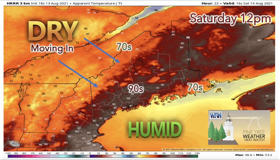 A cold front coming in from the north beginning Friday evening is expected to reach the area this Saturday and move across the state throughout the day. This cold front is expected to help both temperatures and dew points to fall. High temperatures for the day are expected to be cooler in the 70s range west due to NW winds/clouds and east due to onshore winds. This wind setup however, will not likely effect the central areas of the state causing high temperatures in the 90s through this area. Dew points are likely lower Saturday especially north where these temperatures may finally drop below 70 degrees. However humidity is expected to stick around long enough to allow for heat indices reach into the 90s once again. 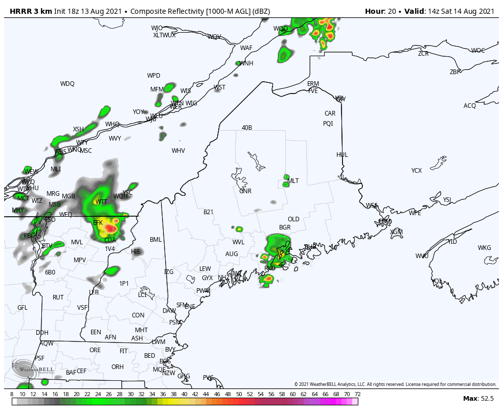 As a result of the incoming cold front more showers and thunderstorms become likely throughout the day and temperatures and humidity will likely begin to fall. Incoming winds from the NW will push dry air overhead while an opposing Seabreeze will advect plenty of moisture. This clashing of air masses should be the spark for storm development Saturday. Areas that are likely to be the first to see the most precipitation and stormy weather include the western boarder of the state and highland areas. Showers and a few storms from Friday night may roll over into Saturday morning but the timing for more severe weather still has some uncertainty. At this time models are favoring the largest mass of storms to arrive by noontime on Saturday. Keep an eye on the sky as these storms are expected to develop quite quickly. Significant relief Sunday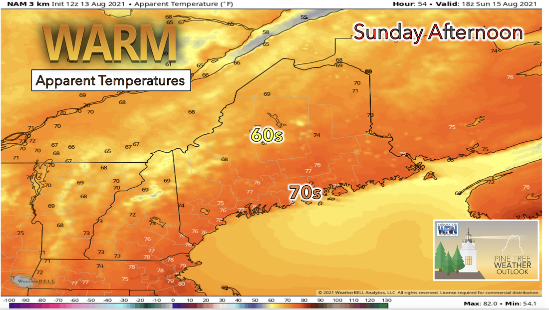 A dryer day is expected for Sunday even though a northern stream trough is likely to move overhead due to dryer air at lower levels while high pressure crosses to the south. High temperatures Sunday should be close to average for this time of year. Down sloping northwesterly winds should allow for locations along the coast to climb near 80F and air should feel much less humid with dew points dropping down to the 40s and 50s. A zonal flow aloft will likely cause clearer skies on Sunday and overnight Sunday. Lows Sunday night should be around 5 degrees below normal. 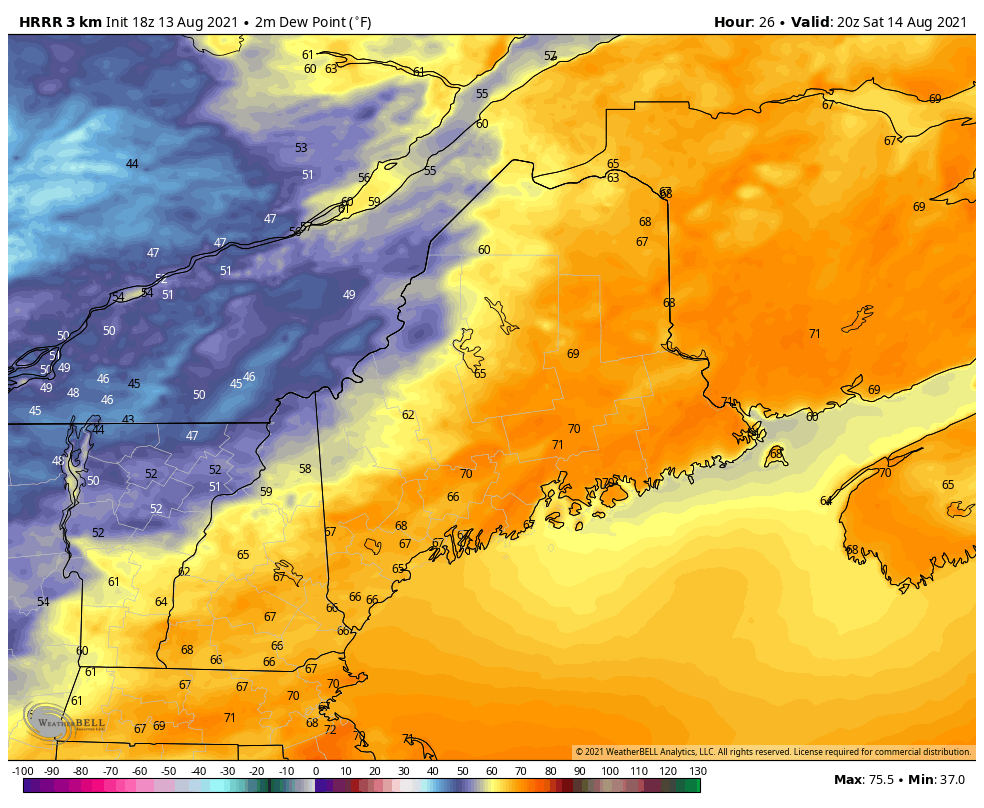 With winds following a zonal pattern and moving air into the region from the northwest cooler and drier air advection is expected for Sunday beginning early. As the above graphic shows a cool and dry air mass to the northwest is expected to creep into the region starting late Saturday continuing into Sunday and will likely continue to move across the state throughout the day Sunday. This is expected to cause dew points to be significantly lower than they hav been and averaging in the 50s range for the day. This means much needed drier air appears and finally a break in humidity.  Drier next week with rain potential Wednesday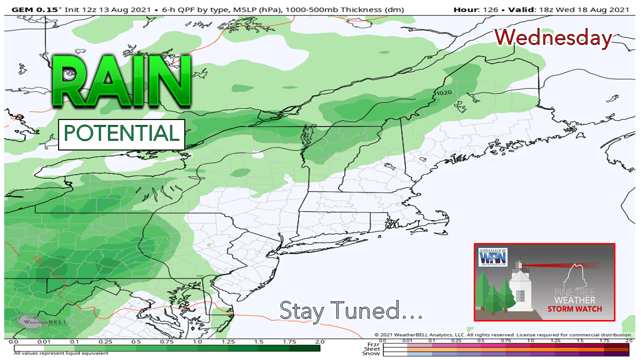 Zonal flow in the upper levels is expected to continue throughout most of the week next week and temperatures are likely to be only slightly above average over this time period. Very little precipitation is expected in the next few days mainly due to the offshore Bermuda High and a high pressure system to the north of Maine. Currently we do not expect to see another chance of rain next week until Wednesday rolls around. Wednesday is expected to see potential for rain and by the afternoon models currently show a weak trough with low heights approaching later on Wednesday which may be the reason for the potential rain this day. Boating Safety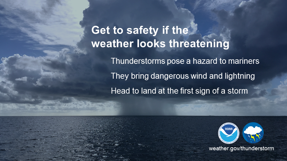 Thunderstorms can be a mariner's worst nightmare. They can develop quickly and can produce strong wind, pounding rain, damaging hail, and deadly lightning. If you see clouds starting to pile up, thunderstorms are likely beginning to develop. Don’t wait until you hear thunder or see lightning. It’s best to head to port or safe shelter at the first sign of a developing storm. weather.gov/safety/safeboating-during Temperature OutlookOne last day of high heat and humidity Friday before temperatures drop back to the normal range for the rest of the week ahead. Sunday has the lowest temperatures and humidity this week for most of the state after storms late Saturday. Temperatures should be back to their normal range in the high 70s to 80s while dew points remain low in the 50s to near 60s. This means air will feel mostly dry next week and days of fair weather are likely to come!  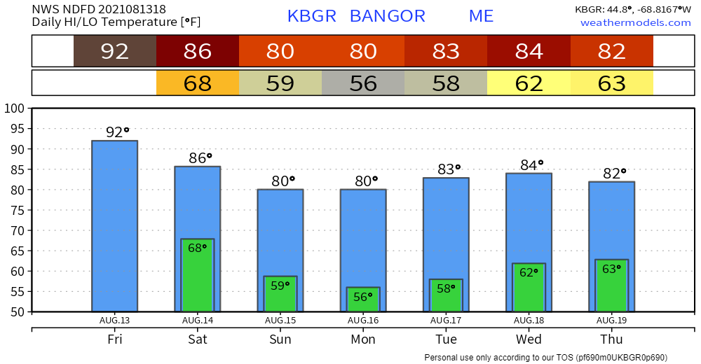 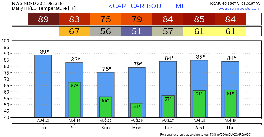 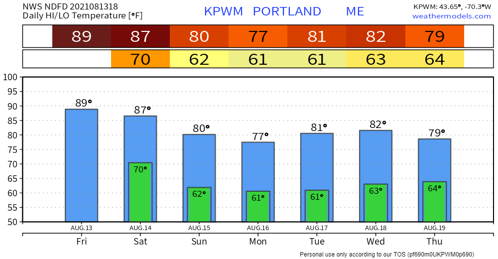 Be prepared to receive alerts and stay updated!  BE PREPARED WITH A NOAA Weather Radio. For $20-$40, it could provide vital information to you when you need it. The weather bands are standard on most public safety scanners, and newer scanner models. Weather radios can be programmed for auto alert. Click here for more information.  ► ► For the latest official forecasts, bulletins, and advisories, please check in with the National Weather Service in Gray for western and southern areas, or Caribou for northern and eastern parts of Maine.  Thank you for your support!
Check back on here tomorrow for a morning update from Sean. -Angelina Find me on Twitter. |

Mike Haggett
|


