
Status update Cape Porpoise, Kennebunkport One thing I am doing this summer compared to previous years is I am getting out and enjoying it. My updates have been erratic as I am getting outside and spending much needed time with my family, and playing golf as much as I can. My family has been through a lot of loss (four deaths to key family members in 30 months), the move to Kennebunk (a year ago April), so taking time to heal, relax, rest and have fun is high on the priority list. Rest be assured that I am keeping watch on what is going on. My forecasts have held up reasonably well as I take a day or two away at times, which I am glad. That has allowed me to take a break, get caught up on real job projects, cut the amount of time I am in the office, and take time for myself and my girls. I need to be careful not to burn myself out, and I fight that from time to time. Anyone that knows me understands that balance in life has been a struggle for me for a long time. I am really working on doing that for my own mental health, and to be a better forecaster, father, husband and friend. Rest be assured, when something with potential weather impacts arises, you will be informed. Here comes the hot & sticky...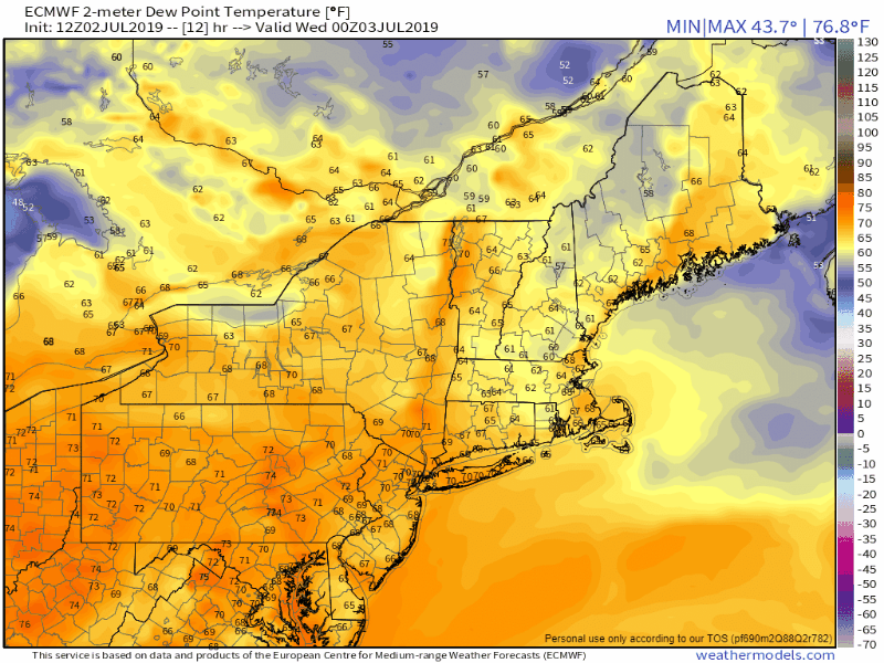 The above loop is that of dew point temperatures running from Tuesday night to Sunday afternoon. The trend is upward. This means uncomfortable sleeping, weather-you-can-wear, sticky conditions. The worst of the humidity appears to be on Saturday, where dew points may reach as high as the low 70s. 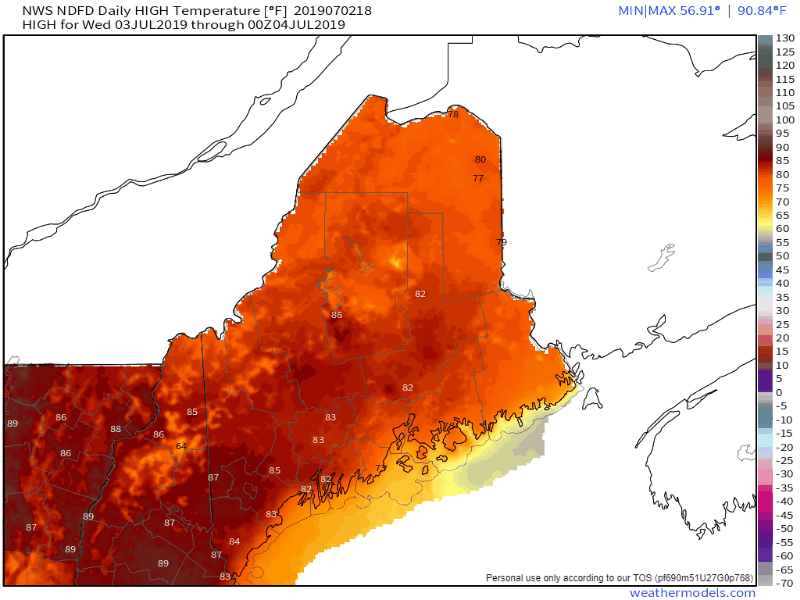 The actual temperatures will gradually rise through Friday. Interior southwestern towns like Fryeburg and Sanford may reach heatwave status (3 days of 90°). While Saturday may be the most humid of the upcoming days, cloud cover from a cold front passing through will help knock the mercury down a bit. By Sunday, it will be back to "Maine summer" conditions with temperatures in the 70s and dew points in the 50s. 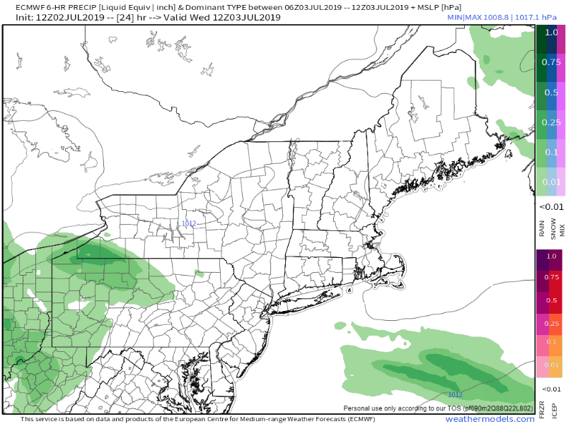 Northern and eastern areas may be dealing with fog Wednesday morning, and perhaps an isolated shower or thunderstorm in the afternoon. The Fourth and Friday appear mainly dry. With the humidity on the increase, I can't rule out the potential for a pop up thunderstorm in the western mountains / central highlands, but the risk is remote. Saturday will be the next day for concern for showers and strong to severe storms. After that clears the coast Saturday night, Sunday and Monday will be worth the reward for enduring the heat & humidity with much more comfortable temperatures and dry conditions. Outlook through Sunday With the rise in humidity, fog will be a concern to start off in areas along the coast. I don't expect it will last long. Outflow ahead of the cold front may cause an isolated shower / storm for the mountains and north on Friday. After a sultry, showery and stormy Saturday, Sunday appears to be much drier and back to seasonable temperatures.  If you are headed to the beach, whether ocean or lakeside, don't forget the sunscreen. It will be important to stay hydrated, and to exercise early in the day. Find a way to stay cool, and take it easy through the rest of the week.
Stay on alert in case of pop up storms. Be blessed, and thank you as always for your support! ► ► For the latest official forecasts, bulletins and advisories, please check in with the National Weather Service in Gray for western and southern areas, or Caribou for northern and eastern parts of Maine. Please consider supporting Pine Tree Weather ► ► Your financial donations are much appreciated to keep this site funded and for further development. I sincerely appreciate your support not only financially, but also in sharing my efforts with others. For more information from me, please check the Pine Tree Weather Facebook page as well as my Twitter feed. Always stay weather aware! - Mike |

Mike Haggett
|


