Pine Tree Weather
  • DISCUSSIONS
  • DONATE
  • WEATHER WALL
  • MAPS
  • RAIN OUTLOOK
  • SEVERE
  • MARINE
  • CPC OUTLOOK
  • Kennebunk
  • MY BIO
  • PTW IN MEDIA
  • OBSERVING WEATHER
  • INTERNSHIPS
  • INTERN ALUMNI
  • DISCUSSIONS
  • DONATE
  • WEATHER WALL
  • MAPS
  • RAIN OUTLOOK
  • SEVERE
  • MARINE
  • CPC OUTLOOK
  • Kennebunk
  • MY BIO
  • PTW IN MEDIA
  • OBSERVING WEATHER
  • INTERNSHIPS
  • INTERN ALUMNI

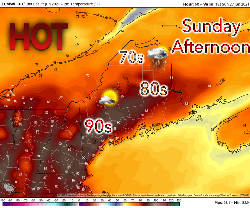
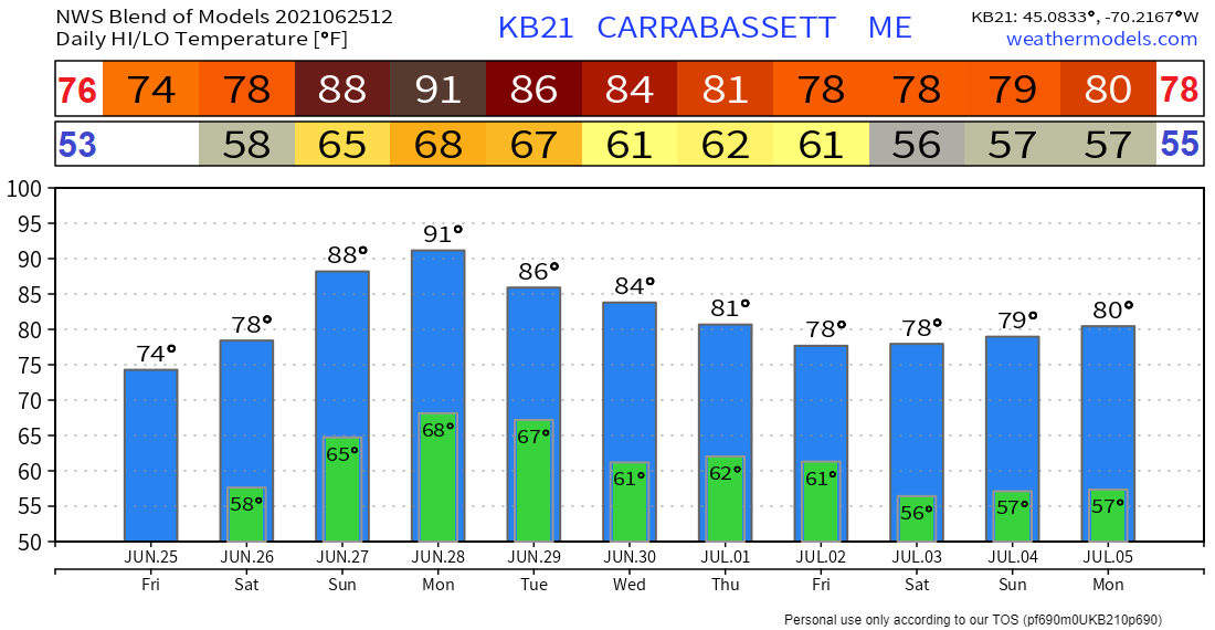
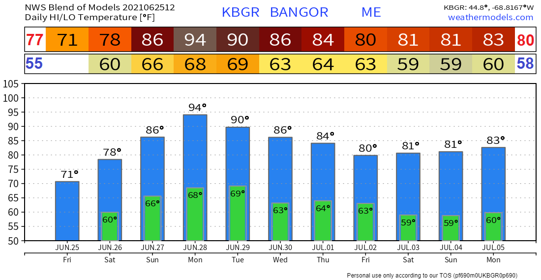
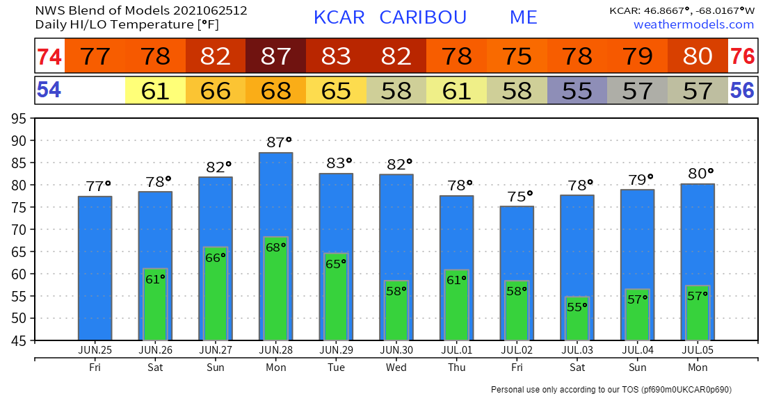
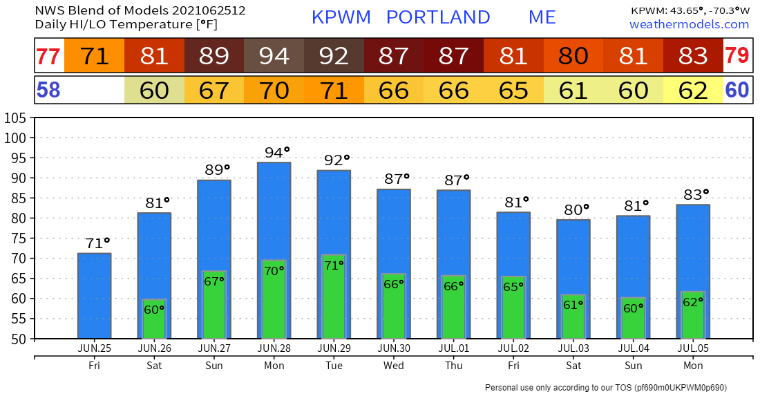
Heat and humidity increase over the weekend along with a chance for showers and thunderstorms

6/25/2021

Comments


Warm temperatures and scattered showers for Saturday

Picture
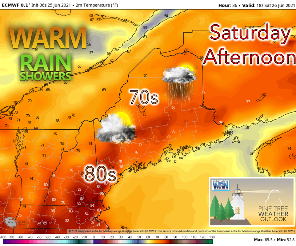
As coastal fog burns off early and daytime heating begins, ​Saturday will mark the start of a warming trend across the state continuing into next week. Temperatures will be in the 70’s although a few interior locations, especially towards the south are likely to reach the 80’s. The exception will be along the coast where a sea breeze will set up, keeping temperatures cooler. As pockets of shortwave energy at 500mb pass through the area, showers will develop in the afternoon primarily in the northern regions. These showers, however, will likely not bring any significant relief to ongoing drought conditions. 

Hot and humid on Sunday with scattered showers and thunderstorms
​

Picture
​Temperatures could surpass 90 in the southern interior regions while farther north temperatures are likely to stay in the 70’s. A sea breeze will keep the coast on the cooler side with temperatures in the 70’s along the southern coast and possibly below 70 along the northern coast. Dewpoints as high as 70 in some locations will make the air uncomfortable where temperatures are the warmest. As pockets of shortwave energy continue to traverse the area, scattered showers and thunderstorms will linger throughout the day towards the north. Otherwise, the region should see a mix of sun and clouds to the north and mostly sunny skies to the south. Overnight, there is the possibility for some fog to develop around the MidCoast region

A hot and humid start to the week

Picture
​The pattern of hot and humid weather continues into next week with temperatures looking to be even hotter than over the weekend, potentially reaching the mid-90’s in the southern interior regions on Monday and Tuesday. Temperatures will again be cooler towards the north, possibly not exceeding 80. Showers and thunderstorms will be present across much of Maine and the chance for an isolated severe storm exists. A weaker sea breeze may allow the southern coast to heat up and stay in the 80’s as winds will be pushing hot, continental air offshore. Conditions will also be very humid as dewpoints stay in the 60’s and even 70’s in a few places on Monday before becoming more comfortable by the end of the day on Tuesday.
Picture
Some scattered storms will move through the area on Monday. The possibility of a severe storm or two cannot be ruled out.

More warm weather for the remainder of next week with scattered showers and thunderstorms
​

Picture
Temperatures will remain warm but not quite as hot as the beginning of next week. Humidity should also not be quite as stifling as Monday and Tuesday. Scattered showers and thunderstorms will be present across the region each day and some may persist into the overnight hours. Also look out for the chance of a severe storm or two.

Temperature outlook for the weekend and next week

Temperatures increasing through Monday making for some hot conditions. Temperatures trend slightly cooler towards the end of next week. 
Picture
Picture
Picture
Picture

Lightning safety when camping

Picture
Going camping? You are NOT safe from lightning in a tent. Avoid standing under trees. Find a sturdy building for shelter. If you can’t find one and are near your hard-topped vehicle, shelter in it with the windows up.
weather.gov/safety/lightning

​Be prepared to receive alerts and stay updated!

Picture
​BE PREPARED WITH A NOAA Weather Radio.

For $20-$40, it could provide vital information to you when you need it. The weather bands are standard on most public safety scanners, and newer scanner models. Weather radios can be programmed for auto alert.  Click here for more information.

► ► For the latest official forecasts, bulletins, and advisories, please check in with the National Weather Service in Gray for western and southern areas, or Caribou for northern and eastern parts of Maine.  ​
​
Picture

Picture
Thank you for your support!

Check back on Facebook tomorrow for a morning update from Mike! 

-Sean 

Find me on Twitter

​For more information in between posts, please follow Pine Tree Weather on Facebook and Twitter. 

​Thank you for supporting this community-based weather information source which operates by reader supported financial contributions. 

Stay updated, stay on alert, and stay safe!
Comments
    Picture

    Mike Haggett
    Kennebunk, ME

    Weather-Ready Nation
    Ambassador

    Certified Weather
    Forecaster
    Penn State '21

    American Meteorological Society

    National Weather Association
    ​
    ​SKYWARN-CWOP

    Matthew 19:26


    DONATE

    Picture
    Picture
    Picture
    Picture
    Picture

    Picture

    Picture

    Picture

    Picture

    Picture

    Picture

    Picture

    Picture

    Picture

    Picture

    Picture

    Picture


    Archives

    April 2025
    March 2025
    February 2025
    January 2025
    December 2024
    November 2024
    October 2024
    September 2024
    August 2024
    July 2024
    June 2024
    May 2024
    April 2024
    March 2024
    February 2024
    January 2024
    December 2023
    November 2023
    October 2023
    September 2023
    August 2023
    July 2023
    June 2023
    May 2023
    April 2023
    March 2023
    February 2023
    January 2023
    December 2022
    November 2022
    October 2022
    September 2022
    August 2022
    July 2022
    June 2022
    May 2022
    April 2022
    March 2022
    February 2022
    January 2022
    December 2021
    November 2021
    October 2021
    September 2021
    August 2021
    July 2021
    June 2021
    May 2021
    April 2021
    March 2021
    February 2021
    January 2021
    December 2020
    November 2020
    October 2020
    September 2020
    August 2020
    July 2020
    June 2020
    May 2020
    April 2020
    March 2020
    February 2020
    January 2020
    December 2019
    November 2019
    October 2019
    September 2019
    August 2019
    July 2019
    June 2019
    May 2019
    April 2019
    March 2019
    February 2019
    January 2019
    December 2018
    November 2018
    October 2018
    September 2018
    August 2018
    July 2018
    June 2018
    May 2018
    April 2018
    March 2018
    February 2018
    January 2018
    December 2017
    November 2017
    October 2017

Proudly powered by Weebly