Heat continues for the next couple of days, relief is in sight with cooler weather by Thursday6/7/2021 Heat and humidity continue for Tuesday, some relief thanks to cloud cover and shower chances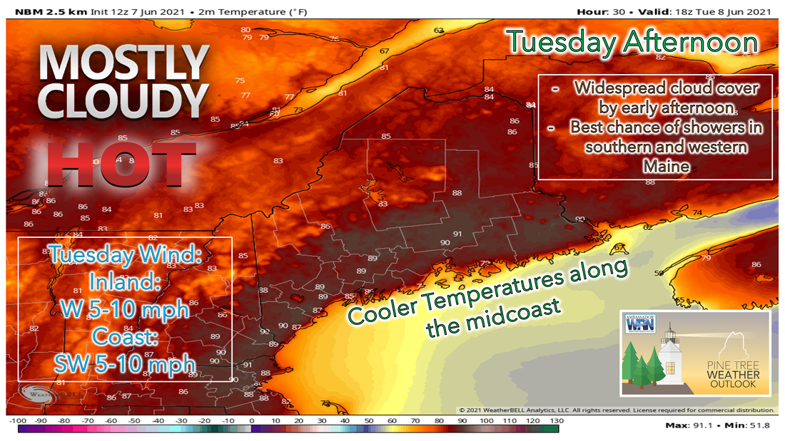 With temperatures falling back into the upper 60s and lower 70s across the state Monday night into Tuesday morning, they won't have to climb that much to be hot once again on Tuesday. There's the possibility that there are some peaks of sunshine during the morning hours on Tuesday, especially the further north and east you are, but clouds will likely fill into the area heading into the afternoon as a cold front approaches the region. 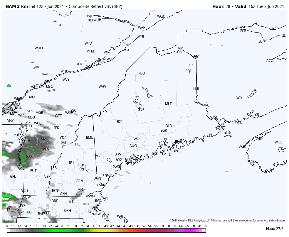 Heading through the late afternoon and into the early evening hours on Tuesday, there's the possibility of seeing scattered showers and thunderstorms form across the central and southern parts of the state. It appears at this point that most of the activity will be scattered, and the threat for widespread severe weather is low. However, I can't rule out the threat of some rumbles of thunder, especially in spots that are able to hang onto the sun for a better part of the day. These showers and thunderstorms likely continue to push southeast through the overnight hours as the weak cold front continues to slowly move into our area. Relief is almost here, one more warm day Wednesday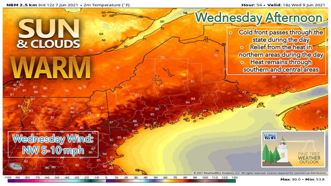 With the cold front likely stalling, if not slowly making its way southeast through the state during the day on Wednesday, expect a split state forecast scenario to setup. The majority of the area has a good chance of seeing cloudy skies waking up Wednesday morning, with more sunshine likely in northern areas. Expect cooler and drier conditions throughout the northern part of the state during the day with temperatures remaining warm climbing into the mid 70s, but dew points will continue to drop throughout the day, making it feel much drier. The southern part of the state likely stays humid through the early afternoon on Wednesday as the cold front takes its time moving through the area. The timing of the cold front will be key as to whether or not the southern half of the state sees showers and storms during the day Wednesday. Most of the models are showing that the front likely moves through during the morning hours. Clearing conditions are likely once the cold front passes through the region, so expect a greater chance of sunny conditions heading into the afternoon Wednesday, especially the further north and east you are. 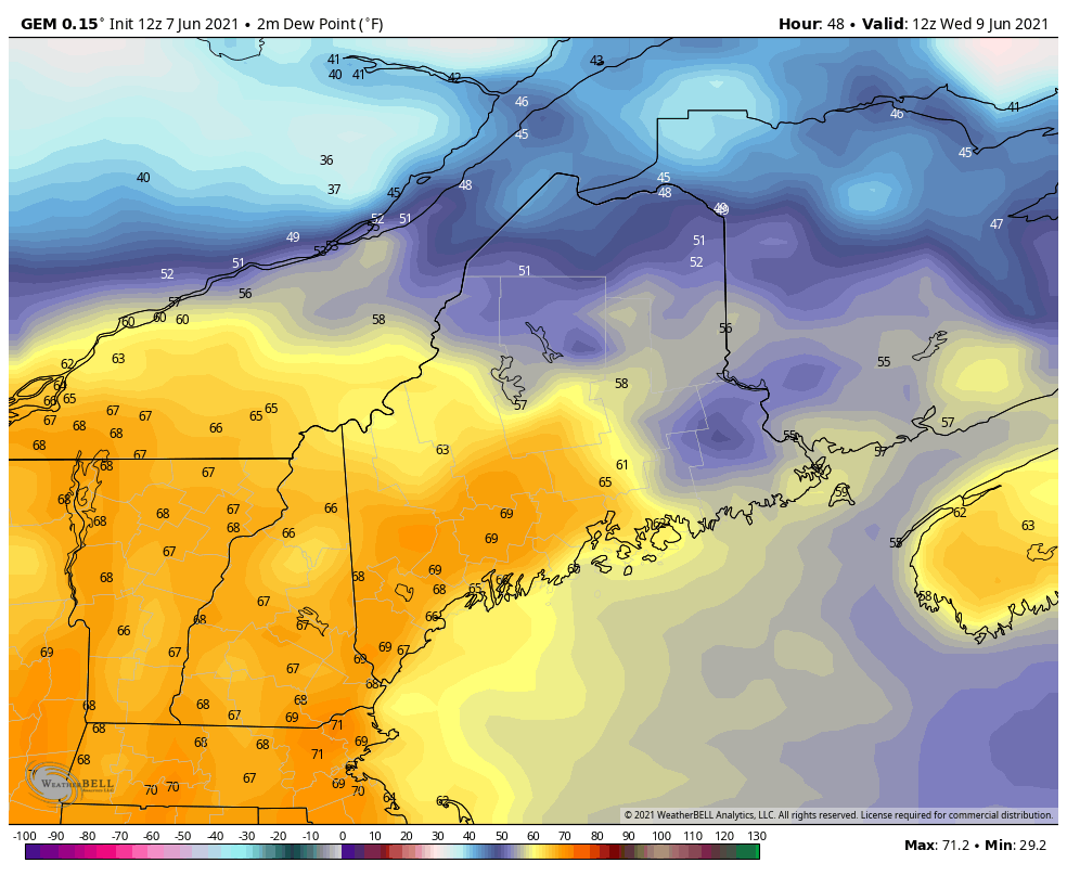 Starting the day on Wednesday, dew points across the northern part of the state are likely to start in the upper 40s and lower 50s, before dropping into the 30s by the early morning hours of Thursday. The central and southern part of the state are likely to hang on to the higher dew points through the day, with southern parts of the state the last to see the cooler and drier air work into the region. With clear skies likely to remain though the overnight hours, temperatures are expected to fall into the 40s and 50s for much of the state. Dry weather continues into Friday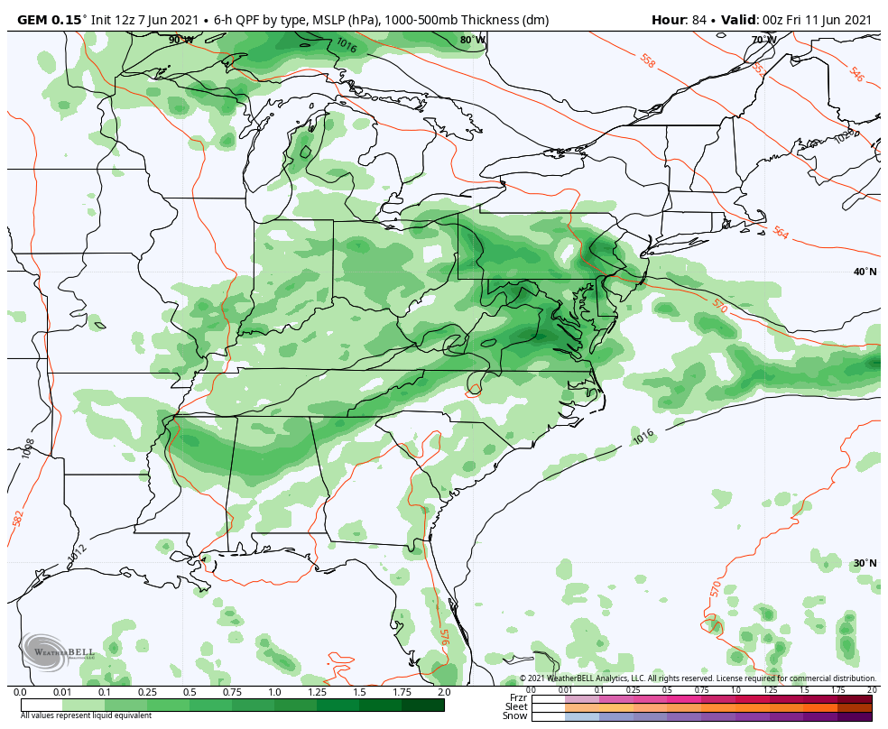 Heading into the Friday, a weak area of high pressure will continue to slide off to our southeast. This allows for a weak shortwave trough to our west to help intensify a low-pressure system to our south. Because of this, Friday looks likely to see clouds increase throughout the afternoon ahead of the trough. The low-pressure system to our south will likely stay to our south on Saturday as the high-pressure system that brought us nice weather for Thursday is likely still close enough to keep the low-pressure system to our south. The most recent model runs have been showing the northern edge of the precipitation associated with this system moving further north, so we'll have to keep an eye on this system as it gets closer. Temperature outlook through SundayKeeping in mind that average high temperatures this time of year are usually in the 70s, most places will likely still be close to if not well above that over the next couple of days. Once cooler air moves into the region Wednesday night into Thursday, temperatures will likely be closer to average, with Friday night being the only possible exception with temperatures likely dropping into the lower 40s in northern areas. Warmer temperatures begin to re-appear in the forecast heading into the weekend and early next week, with high temperatures likely into the mid 70s by Sunday. The red numbers on the charts below indicate the average high temperature for this time of year, while the blue numbers indicate the average low temperature. 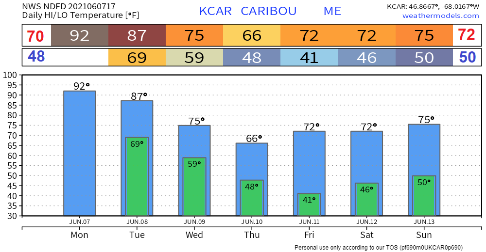 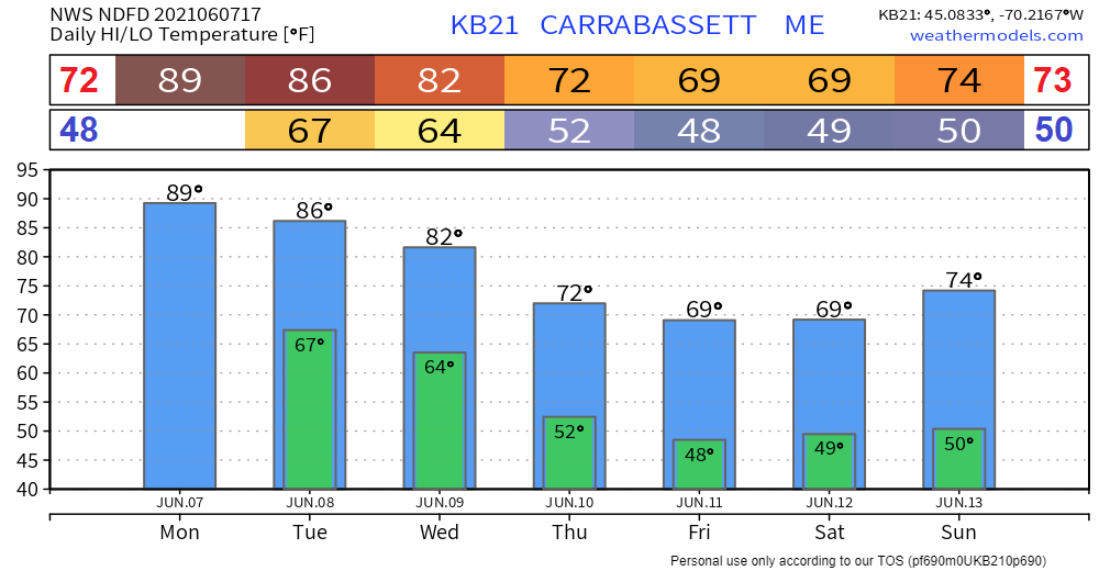 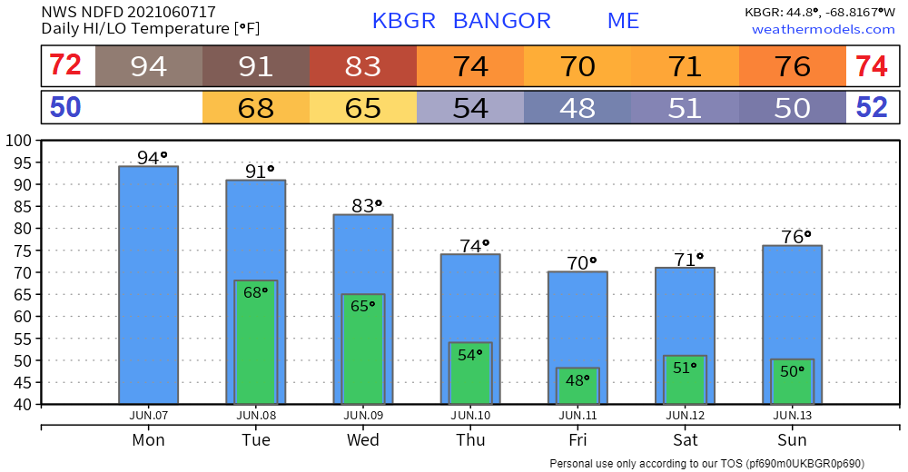 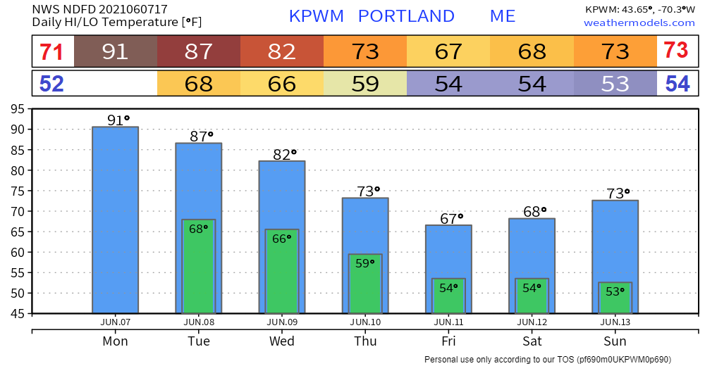 Auto Safety with the Heat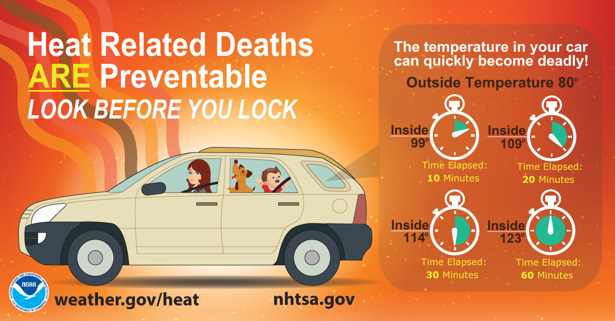 With the heat remaining in the forecast over the next couple of days, now is a great time to remind people to never, never, never leave children, disabled or elderly adults, or pets in parked, unattended vehicles! Studies have shown that the temperature inside a parked vehicle can rapidly rise to dangerous levels for people and pets. Leaving the windows slightly open does not significantly decrease the heating rate. The effects can be more severe on children because their bodies have not developed the ability to efficiently regulate internal temperature. weather.gov/safety/heat-children-pets Be prepared to receive alerts and stay updated!
For more information in between posts, please follow Pine Tree Weather on Facebook and Twitter.
Thank you for supporting this community-based weather information source which operates by reader supported financial contributions. Stay updated, stay on alert, and stay safe! |

Mike Haggett
|