Pine Tree Weather
  • DISCUSSIONS
  • DONATE
  • WEATHER WALL
  • MAPS
  • RAIN OUTLOOK
  • SEVERE
  • MARINE
  • CPC OUTLOOK
  • Kennebunk
  • MY BIO
  • PTW IN MEDIA
  • OBSERVING WEATHER
  • INTERNSHIPS
  • INTERN ALUMNI
  • DISCUSSIONS
  • DONATE
  • WEATHER WALL
  • MAPS
  • RAIN OUTLOOK
  • SEVERE
  • MARINE
  • CPC OUTLOOK
  • Kennebunk
  • MY BIO
  • PTW IN MEDIA
  • OBSERVING WEATHER
  • INTERNSHIPS
  • INTERN ALUMNI

Henri misses Maine, but remnants linger through Tuesday

8/21/2021

Comments


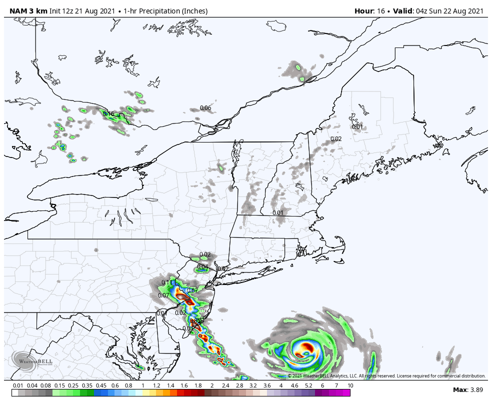
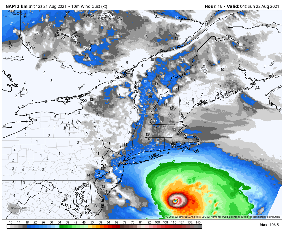
Henri accelerates toward southern New England

Picture
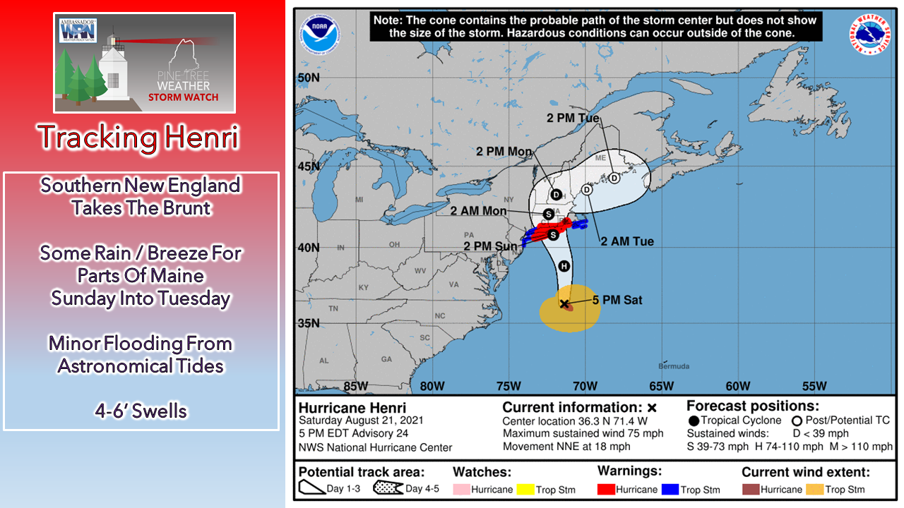
Henri officially became a hurricane according to the National Hurricane Center's 11 AM Saturday advisory. Tropical storm warnings are posted for southeastern Massachusetts, Martha's Vineyard / Nantucket, and west of New Haven, CT to Port Jefferson Harbor, NJ, which also includes New York City. Hurricane warnings are posted from Westport, MA to New Haven, and includes Block Island. 
Picture
Satellite image of Henri through 3 PM shows acceleration of the storm offshore of the Carolinas and parallel to the DelMarVa peninsula, well west of land for now. An upper-level trough is on pace to steer Henri towards Long Island and southern Connecticut, with landfall expected late afternoon on Sunday.  The storm will run into cooler ocean waters before making landfall, then slow to a crawl over central Connecticut, advancing into western Massachusetts early Monday. 

Scattered showers and breeze from Henri
​Sunday through Tuesday

Picture
As typical with tropical systems, the wind, severe potential and storm surge occurs predominantly on the right front quadrant of the storm, and rain on the left front quadrant. This model idea from the NAM shows that well. Outer bands from Henri spin into southern Maine Sunday morning and spread into the mountains by Sunday afternoon. There is a chance for a thunderstorm and/or downpours within those bands, but the main concern with severe potential appears likely for central and southeastern Massachusetts, and Rhode Island.

As the storm weakens, showers and isolated thunderstorms are likely to become more scattered on Monday, to widely scattered on Tuesday.
Picture
The big rain is likely to be an issue for northwest Connecticut, western Massachusetts including the Berkshires, on over to the Albany, NY area. Flash flooding and flood warnings are possible there. For Maine, an easterly wind flow pumps moisture in off the Gulf of Maine and could enhance rainfall amounts on up into the eastern facing slopes of the White Mountains and the taller hills into the western mountains where rain would be graciously appreciated there.
Picture
Wind will be the main concern for eastern Long Island into central Connecticut and western Massachusetts Sunday, then diminish as Henri weakens. For Maine, the shorelines could see gusts upwards of 25-30 mph from the east, but it will be more of a stiff breeze than anything.

The best chance for coastal flooding appears to be the high tide around midnight Monday. With the easterly breeze off the ocean and the tide astronomically high, some minor flooding and potentially some splash over in exposed areas from 4-6' swells are possible.

Picture

Next chance for rain Thursday

Picture
After the remnants of Henri pass to the east on Tuesday, this will set up a sunny, warm humid day on Wednesday. A cold front advances into the region from the northwest on Thursday, which brings a chance for showers and storms statewide. The state appears to snap the long period of humidity on Friday, with more seasonable temperatures headed in for the weekend.

CoCoRaHS precipitation reports are needed in Maine! 

Picture
Ever wanted to take rain or snow measurements? Join CoCoRaHS or Community Collaborative Rain, Hail, and Snow Network. This volunteer network of observers measures precipitation from their backyards. Any age can volunteer. Data is used by NWS meteorologists to help with forecasts. For more information ► https://www.cocorahs.org/state.aspx?state=me​

Temperature outlook through Thursday

Warm, humid nights continue statewide through much of the week ahead. Temperatures remain above normal through most of the period. 
Picture

Be prepared to receive alerts and stay updated!

Picture
BE PREPARED WITH A NOAA Weather Radio.
​
​For $20-$40, it could provide vital information to you when you need it. The weather bands are standard on most public safety scanners, and newer scanner models. Weather radios can be programmed for auto alert. Click here for more information.

​► ► For the latest official forecasts, bulletins, and advisories, please check in with the National Weather Service in Gray for western and southern areas, or Caribou for northern and eastern parts of Maine.
Picture

​​For more information in between posts, please follow Pine Tree Weather on Facebook and Twitter. 

​Thank you for supporting this community-based weather information source which operates by reader supported financial contributions. 

Stay updated, stay on alert, and stay safe!

​- Mike

Comments
    Picture

    Mike Haggett
    Kennebunk, ME

    Weather-Ready Nation
    Ambassador

    Certified Weather
    Forecaster
    Penn State '21

    American Meteorological Society

    National Weather Association
    ​
    ​SKYWARN-CWOP

    Matthew 19:26


    DONATE

    Picture
    Picture
    Picture
    Picture
    Picture

    Picture

    Picture

    Picture

    Picture

    Picture

    Picture

    Picture

    Picture

    Picture

    Picture

    Picture

    Picture


    Archives

    April 2025
    March 2025
    February 2025
    January 2025
    December 2024
    November 2024
    October 2024
    September 2024
    August 2024
    July 2024
    June 2024
    May 2024
    April 2024
    March 2024
    February 2024
    January 2024
    December 2023
    November 2023
    October 2023
    September 2023
    August 2023
    July 2023
    June 2023
    May 2023
    April 2023
    March 2023
    February 2023
    January 2023
    December 2022
    November 2022
    October 2022
    September 2022
    August 2022
    July 2022
    June 2022
    May 2022
    April 2022
    March 2022
    February 2022
    January 2022
    December 2021
    November 2021
    October 2021
    September 2021
    August 2021
    July 2021
    June 2021
    May 2021
    April 2021
    March 2021
    February 2021
    January 2021
    December 2020
    November 2020
    October 2020
    September 2020
    August 2020
    July 2020
    June 2020
    May 2020
    April 2020
    March 2020
    February 2020
    January 2020
    December 2019
    November 2019
    October 2019
    September 2019
    August 2019
    July 2019
    June 2019
    May 2019
    April 2019
    March 2019
    February 2019
    January 2019
    December 2018
    November 2018
    October 2018
    September 2018
    August 2018
    July 2018
    June 2018
    May 2018
    April 2018
    March 2018
    February 2018
    January 2018
    December 2017
    November 2017
    October 2017

Proudly powered by Weebly