Pine Tree Weather
  • DISCUSSIONS
  • DONATE
  • MAPS
  • NWS BRIEFINGS
  • SATRAD
  • MARINE
  • SNOW / ICE OUTLOOK
  • RAIN OUTLOOK
  • CPC OUTLOOK
  • Kennebunk
  • OBSERVING WEATHER
  • Who We Are
  • My Photography
  • DISCUSSIONS
  • DONATE
  • MAPS
  • NWS BRIEFINGS
  • SATRAD
  • MARINE
  • SNOW / ICE OUTLOOK
  • RAIN OUTLOOK
  • CPC OUTLOOK
  • Kennebunk
  • OBSERVING WEATHER
  • Who We Are
  • My Photography

Hot and Muggy Start to the Week, Slight Cool-down Later in the Week

6/21/2020

Comments


Hot and Muggy Monday, Chance for Afternoon Storms

Picture
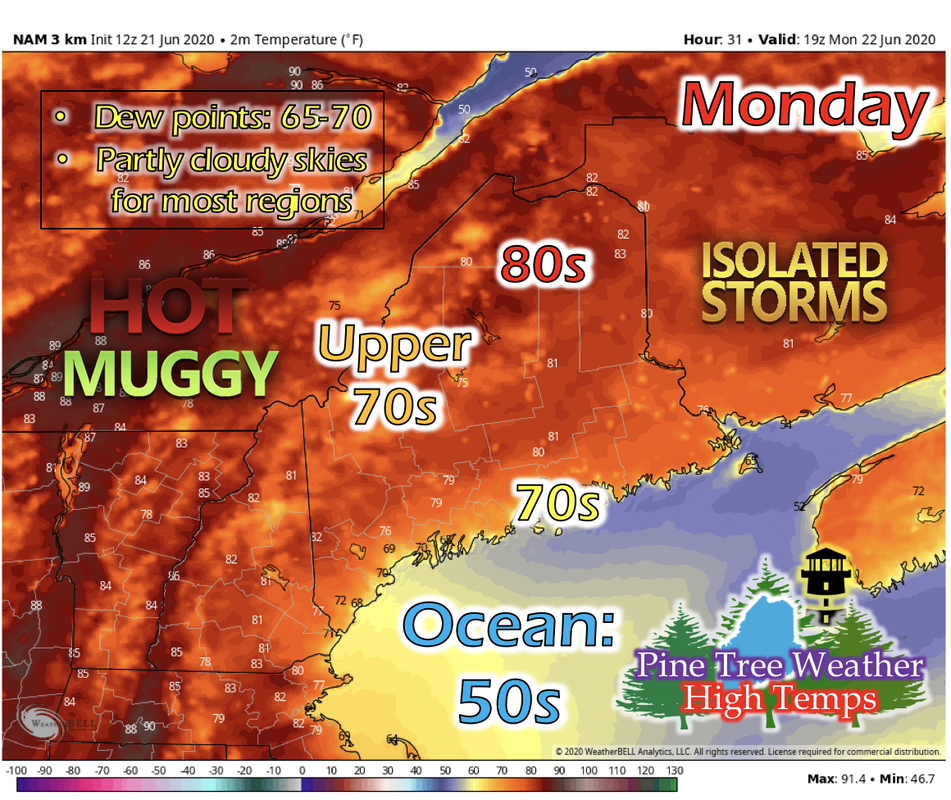
Another hot and muggy day for Maine for the start of the week. Northern and central Maine is looking at temperatures in the 80s, while western and mountainous regions are in the upper 70s. As the afternoon sea breeze sets in, coastal areas are looking at temperatures in the 70s.

As the day begins to heat up, isolated thunderstorms for northern and western Maine are possible for the afternoon. Lack of energy and cooling of temperatures should keep these storms within these regions, but a stray pop-up storm is always possible in the summertime.

Tuesday: Similar Temperatures to Monday

Picture
Temperatures for Tuesday are similar to Monday's, as well as dew points and cloud cover. The only change is the likelihood of afternoon thunderstorms. The amount of energy that an ensemble model is predicting for Tuesday is lower than previous days, so the probability is lower. This isn't ruled out, however. As long as there's some energy in the atmosphere, there could be some small pop-up afternoon storms for mainly northern and western Maine, but the chance is lower than for Monday. 

Temperature and Rain Outlook for this Week

Picture
The GIF above runs from 7 PM Tuesday to 7 PM Friday. As a low pressure system begins to approach Maine from the west on Tuesday, temperatures will stay similar to Tuesday's until Thursday, where daytime temperatures will begin to cool slightly as a cold front pushes through. Exact timing and location of the cold front will be monitored as more information from numerical models is available to us.
Picture
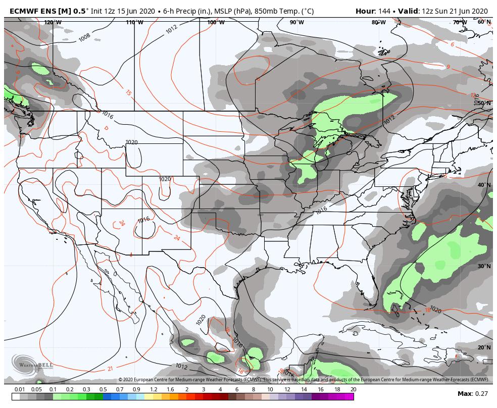
The GIF above runs from 7 AM Sunday to 7 AM Wednesday. The low pressure system begins to push its way north of Maine on Wednesday, according to this long-range model's most recent run. Though there is a chance of rain, amount, location, and timing are still very much in the air at this time. More information will become available in the next few days.

Cold Water Safety

Picture
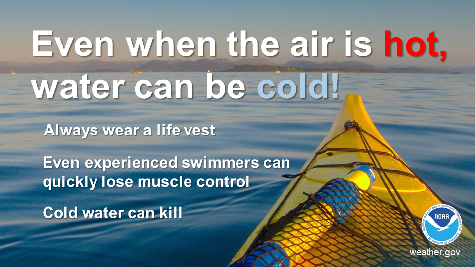
Ocean and lake temperatures for Maine are 50s and 60s respectively. Warm air temperatures doesn't necessarily mean warm water temperatures. Cold water drains body heat up to 25 times faster than cold air. When cold water makes contact with your skin, cold shock causes an immediate loss of breathing control. This dramatically increases the risk of sudden drowning even if the water is calm and you know how to swim. Practice cold water safety by staying out of waters below 70 degrees!

​Help forecast verification, and stay informed!

Picture
mPINGers Wanted! Report your weather anywhere anytime anonymously and help improve forecast verification. No special training required. Download the mPING app and start reporting what you see from any location.  For more information, check out the mPing site. ​

Picture
Hiking, camping or boating this summer?
BE PREPARED WITH A
 
NOAA Weather Radio.

​For $20-$40, it could provide important information to you when you need it. The weather bands are standard on most public safety scanners, and newer scanner models and weather radios can be programmed for auto alert.  
Click here for more information.

Picture
​​​► ► For the latest official forecasts, bulletins and advisories, please check in with the National Weather Service in Gray for western and southern areas, or Caribou for northern and eastern parts of Maine.

For more information, please follow Pine Tree Weather on Facebook and Twitter. 

Thank you for supporting this community based weather information source that is funded by your financial contributions. 

Stay updated, stay on alert, and stay safe!

Have a great Father's Day, and have a wonderful week!

- Kaitlyn
Comments
    Picture

    Mike Haggett
    Kennebunk, ME

    Certified Weather
    Forecaster
    Penn State '21

    American Meteorological Society

    National Weather Association

    Weather-Ready Nation 
    Ambassador
    ​
    ​SKYWARN-CWOP

    Matthew 19:26


    Support
    Pine Tree Weather

    DONATE

    Picture

    Picture

    Picture

    Picture

    Picture

    Picture

    Picture

    Picture

    Picture

    Picture

    Archives

    January 2023
    December 2022
    November 2022
    October 2022
    September 2022
    August 2022
    July 2022
    June 2022
    May 2022
    April 2022
    March 2022
    February 2022
    January 2022
    December 2021
    November 2021
    October 2021
    September 2021
    August 2021
    July 2021
    June 2021
    May 2021
    April 2021
    March 2021
    February 2021
    January 2021
    December 2020
    November 2020
    October 2020
    September 2020
    August 2020
    July 2020
    June 2020
    May 2020
    April 2020
    March 2020
    February 2020
    January 2020
    December 2019
    November 2019
    October 2019
    September 2019
    August 2019
    July 2019
    June 2019
    May 2019
    April 2019
    March 2019
    February 2019
    January 2019
    December 2018
    November 2018
    October 2018
    September 2018
    August 2018
    July 2018
    June 2018
    May 2018
    April 2018
    March 2018
    February 2018
    January 2018
    December 2017
    November 2017
    October 2017

    RSS Feed

Proudly powered by Weebly