
Scorching Sunday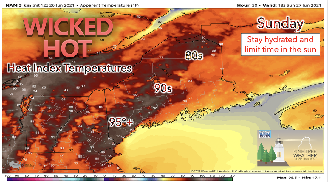 We are in for a wicked hot day as Sunday kicks off the hotter trend for the upcoming week. A strong stationary high pressure system off the coast of Maine is the reason that we are likely to see a spike in temperatures. Dew points will continue to be higher in the above 60 range for Sunday, which will make for humid conditions. For the South, skies are forecasted to be sunnier on Sunday due to an upper level ridge overhead which will allow for increased surface level heating. Therefore highs for the day in this area are forecasted to fall between the high 80s and low 90's with some interior regions reaching into the mid 90s. As for the northern half of the state, showers are likely to persist throughout most of the day with the possibility of moderate to heavy rain in some areas due to increased surface heating. The high temperatures for the day in the north will be more limited by clouds and rain and are therefore expected to be in the 80s. The high heat along with increased dew points has the heat index predicting temperatures as high as the 95+ range for some southern regions. It would be smart to limit time in the direct sun and take precautions if you cannot avoid doing so.  Overnight Saturday into early Sunday fog will be likely and conditions are predicted to almost exactly mimic fog from Saturday morning, especially across the Downeast region. The incoming cold front is expected to cause lifting of warm air ahead of it. Therefore, it is likely that the north will experience stratiform rain over the St. John Valley with showers extending to the south of this region. Rain is likely to last throughout the day Sunday and into Monday for the upper half of the state. Even Hotter for Monday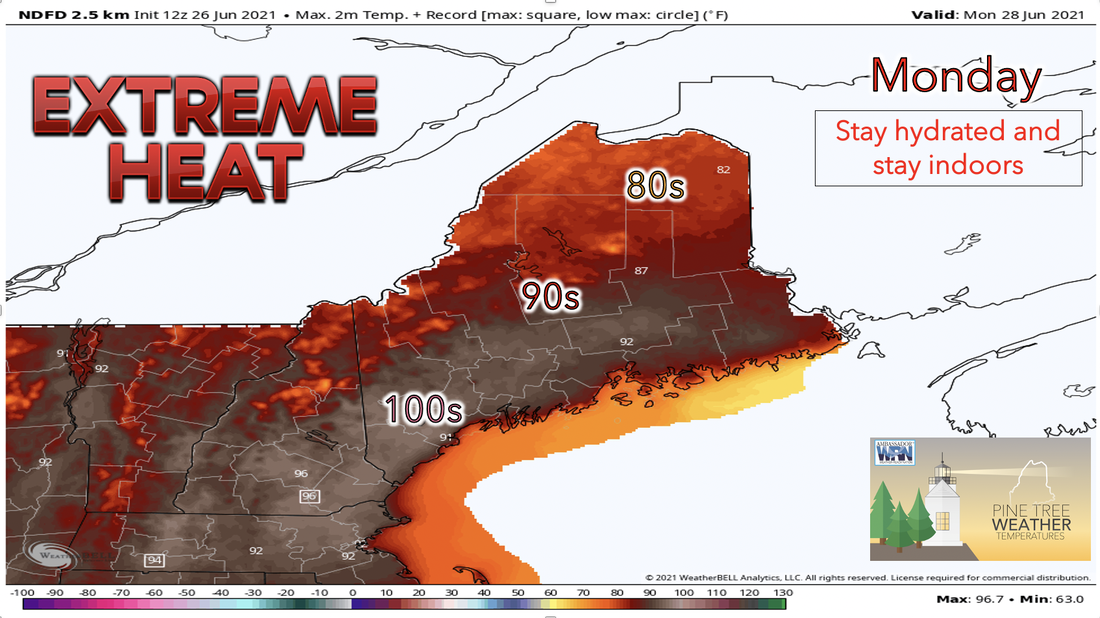 If you thought Sunday was hot, think again. Extreme heat is in the forecast for Monday and it is going to be brutal. Dewpoints are not likely to cool down either so we are in for another hot and humid day. Highs for the day are forecasted to be in the low to mid 90s south of the mountains and some areas of the south show potential to reach the 100s range, yikes! Some potential still for rain showers and thunderstorms in the north due to an incoming shortwave later, on Monday afternoon. The largest chance for thunderstorms is expected to be in the Central Highlands and in Southern Aroostook. With the high heat today, areas of the south are likely to be able to break a few records. This amount of heat can become very dangerous very quickly so be diligent and stay aware! Pattern continuing Tuesday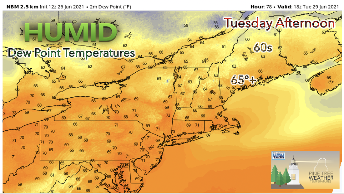 Not a huge change for Tuesday as temperatures begin to dip only slightly as the strong upper level ridge begins to move away to the southeast. As the ridge continues to retreat temperatures will decline causing Wednesdays temperatures to be slightly more seasonable with highs in the mid to low 80s. Highs for Tuesday are forecasted to be considerably high still in the mid 80s to low 90s. Unfortunately, dew point temperatures are most likely going to continue to remain within the mid 60's range throughout the rest of the week into Friday. This means the air will continue to feel stuffy and sticky even as temperatures begin to fall. A rainy end of the week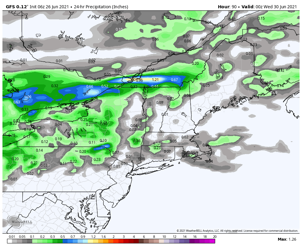 Rain starting Wednesday helps break up the heat but does little to stifle the humidity levels. As Wednesday begins a rainy weather system moves in from the west and moves eastward throughout the day. This means cloudy conditions and scattered rain for most of Maine on Wednesday. Temperatures are likely to break away from the highs from Monday and Tuesday and will remain within the mid to low 80s for most places. Scattered rain and Thunderstorms are scheduled to continue into Thursday and Friday as well with more rainfall and higher accumulation totals along the coastline. The air mass across the eastern CONUS will be moist and unstable Wednesday through Friday therefore, isolated severe threats may develop each day in certain locations if enough destabilization is overlapping modest winds aloft in these locations. Most models however, are still uncertain of where this may occur this early on. A break in this wetter weather is expected by Saturday. Temperature trend through FridayVery high temperatures beginning Sunday and continuing through Tuesday when an increase in cloud coverage and retreat of the upper level ridge on Wednesday and will cause temperatures to decrease through Friday. Dew points remain above 60 until Friday when they begin to drop down. This trend is expected to continue into the holiday weekend where temperatures and dew points are likely to be more seasonal. 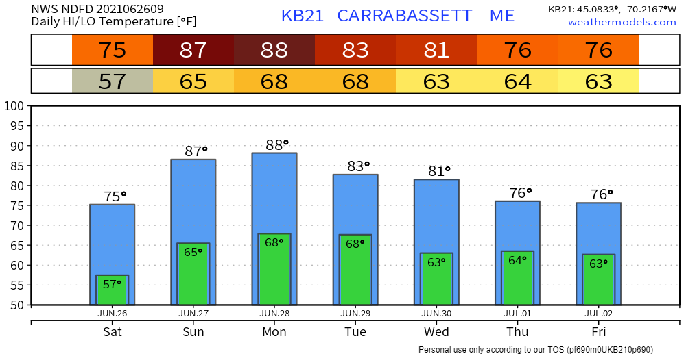 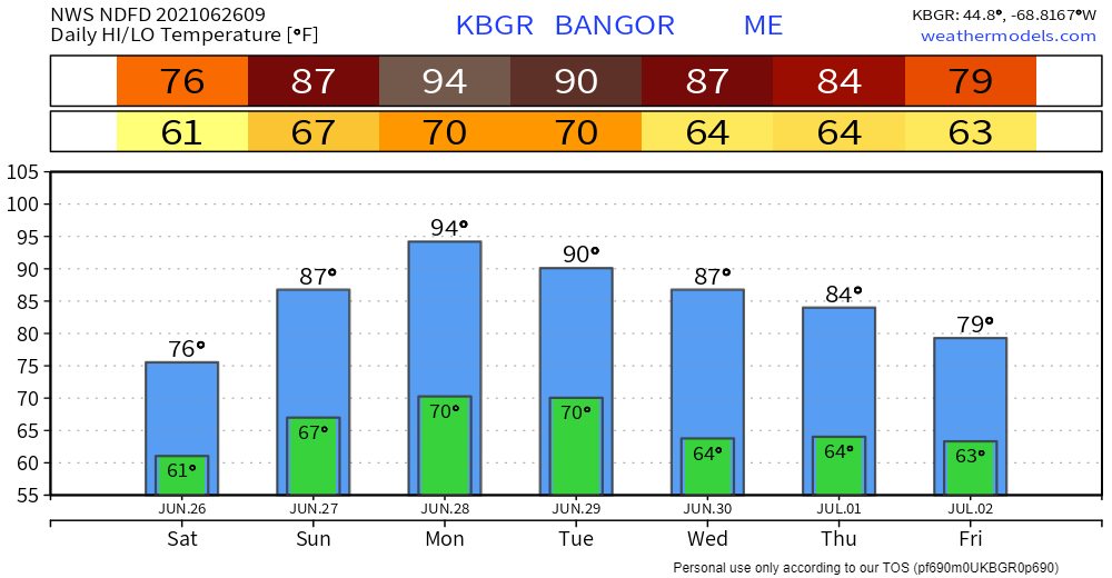 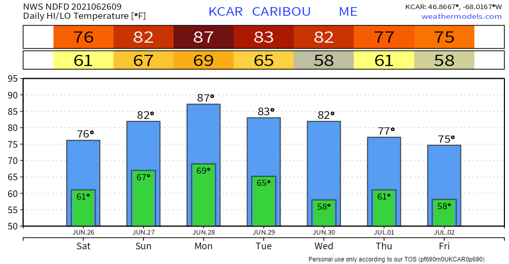 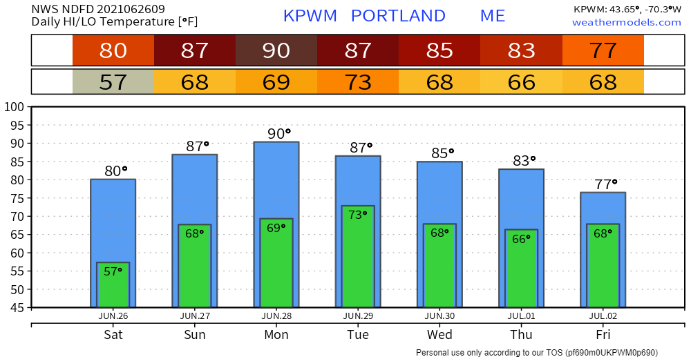 Heat can escalate quickly Warm temperatures can quickly rise to dangerous levels — especially in the summer and in parked cars. Stay Weather-Ready and don’t underestimate the heat. weather.gov/safety/heat Be prepared to receive alerts and stay updated!BE PREPARED WITH A NOAA Weather Radio. For $20-$40, it could provide vital information to you when you need it. The weather bands are standard on most public safety scanners, and newer scanner models. Weather radios can be programmed for auto alert. Click here for more information.  ► ► For the latest official forecasts, bulletins, and advisories, please check in with the National Weather Service in Gray for western and southern areas, or Caribou for northern and eastern parts of Maine. 
|

Mike Haggett
|


