Pine Tree Weather
  • DISCUSSIONS
  • DONATE
  • WEATHER WALL
  • MAPS
  • RAIN OUTLOOK
  • SEVERE
  • MARINE
  • CPC OUTLOOK
  • Kennebunk
  • MY BIO
  • PTW IN MEDIA
  • OBSERVING WEATHER
  • INTERNSHIPS
  • INTERN ALUMNI
  • DISCUSSIONS
  • DONATE
  • WEATHER WALL
  • MAPS
  • RAIN OUTLOOK
  • SEVERE
  • MARINE
  • CPC OUTLOOK
  • Kennebunk
  • MY BIO
  • PTW IN MEDIA
  • OBSERVING WEATHER
  • INTERNSHIPS
  • INTERN ALUMNI

Hot weekend, then a slight cool down before the next chance of rain

6/18/2020

Comments


Hot and dry weekend

Picture
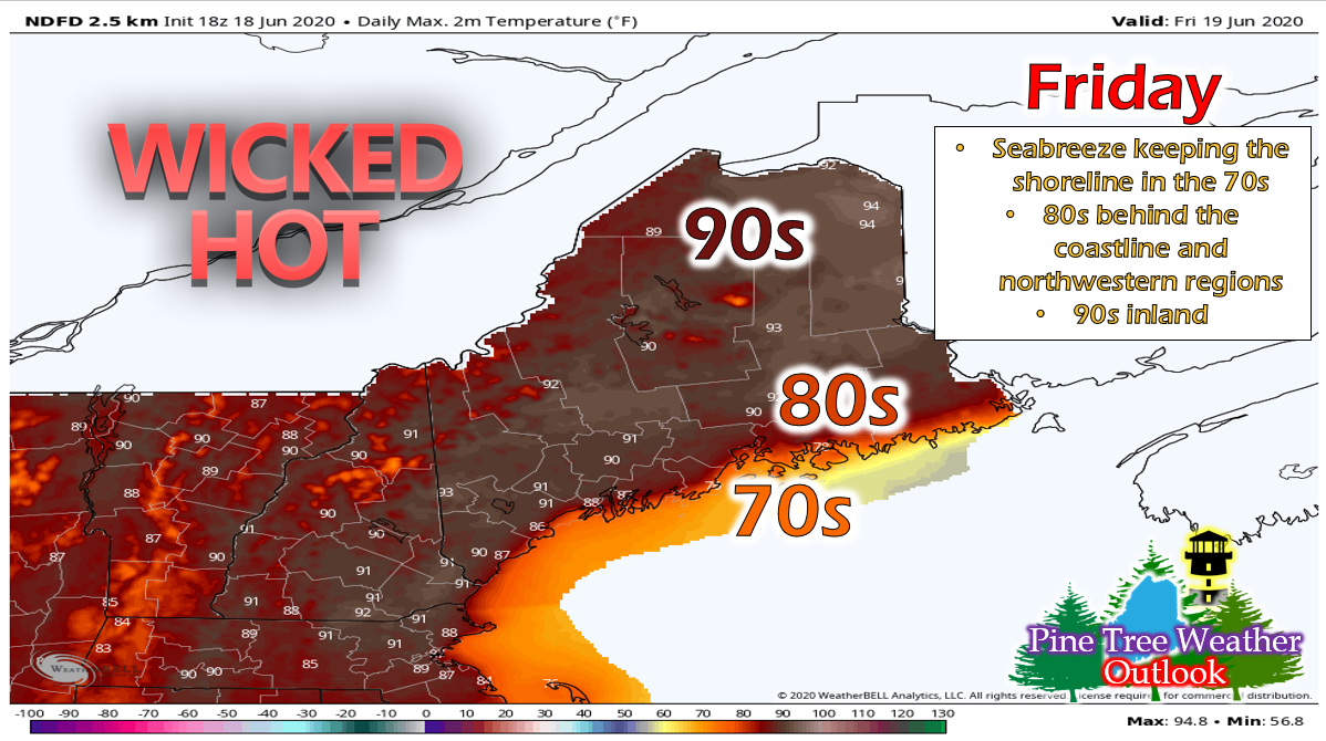
Friday could feature some record-breaking high temperatures in northern regions of the state, especially Caribou. In fact, temperatures will rise into the 90s throughout most of inland Maine. Mid-upper 80s can be expected along the coastal plain and in northwestern regions of the state, while a seabreeze (7-10 mph) will keep the immediate coast in the mid-upper 70s. Skies will be mostly clear with a couple high clouds lingering in the southwestern portions of the state. Dew points will be in the upper 50s and low 60s throughout much of the state, with the exception of the southwestern portions of the state which could see mid-upper 60s. If you live in this area, please try to stay indoors as much as possible. 

Overnight, temperatures will drop into the upper 50s and low 60s. Fog may form along coastline. 
Picture
As the backdoor cold front encroaches on the state, temperatures on Saturday will be slightly cooler, with low 90s in the central portions of the state, 70s along the shoreline and 80s elsewhere. Dew points will be similar to Friday, mainly in the low 60s with some mid-upper 60s along the southwestern regions. Clouds will move in during the day ahead of some showers and thunderstorms that are expected to pop up along the front during the afternoon hours. 

Overnight temps will be similar again, with mainly low 60s state wide. Fog is also a threat again along the coastline. 

Slight cool down and moisture moving in

Picture
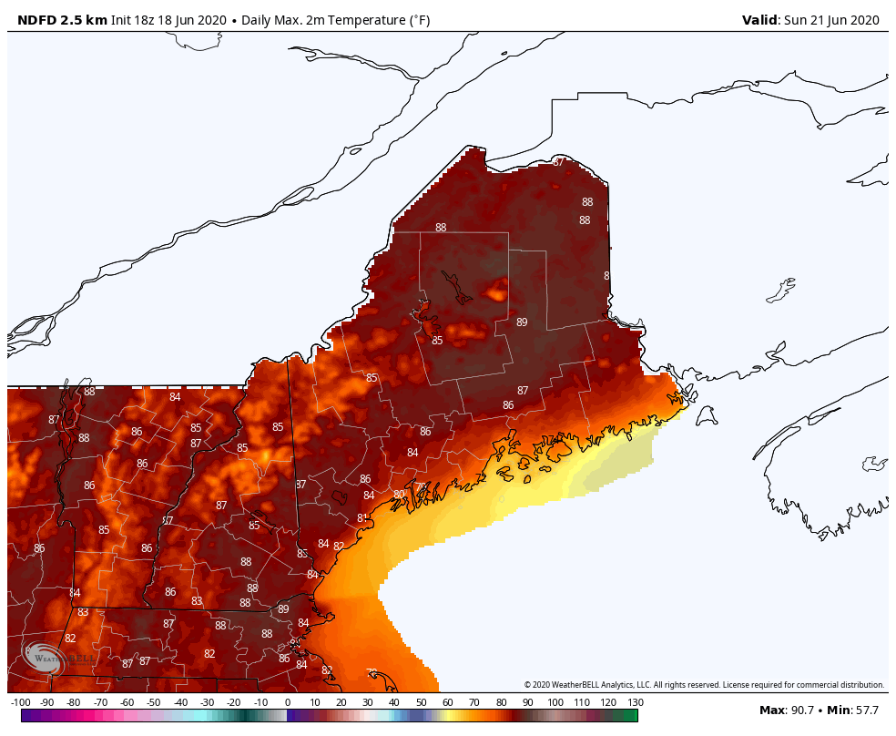
High Temperatures for Sunday 6/21 to Tuesday 6/23
We begin to see a little cool down as we head into next week, with upper 80s on Sunday, and low-mid 80s Monday and Tuesday. Dew points stay in the low-mid 60s which, along with the upper level disturbance over the area, increases the threat for showers and thunderstorms during those days.
Picture
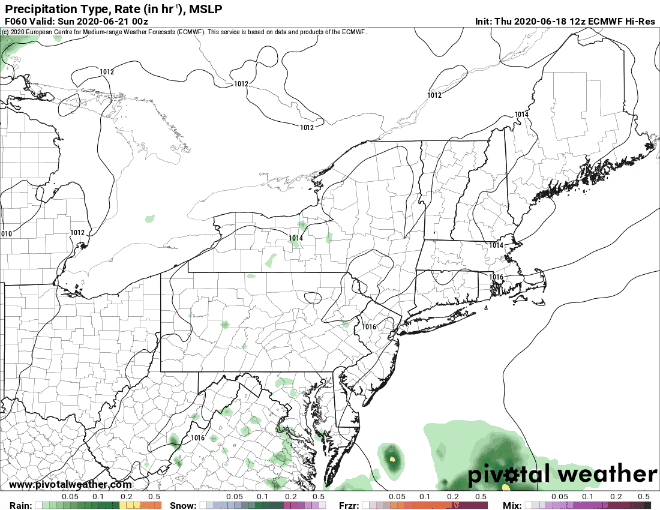
European Model Rain Forecast from Saturday Night to Tuesday Night
As mentioned above, the threat for pop-up showers and thunderstorms during the afternoon hours increases as moisture moves into the area. As the time grows closer, we will have more updates on timing and location. 

Staying safe in hot weather

Picture
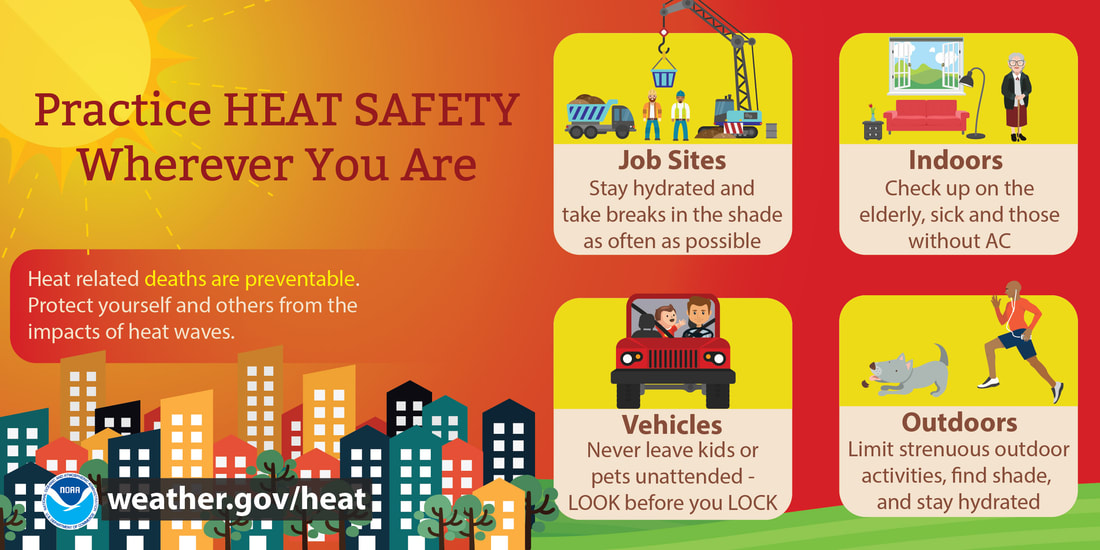
As we've been/continue to be impacted by hot weather, it's important to remember how to stay safe during these times. Remember to stay hydrated and limit outside activity, especially if dew points are relatively high. Never leave pets or children (or yourself) in the car, as it only takes a short amount of time for it to become life-threateningly hot inside.

Help forecast verification, and stay informed!

Picture
mPINGers Wanted! Report your weather anywhere anytime anonymously and help improve forecast verification. No special training required. Download the mPING app and start reporting what you see from any location.  For more information, check out the mPing site.

Picture
Hiking, camping or boating this summer?
BE PREPARED WITH A
 
NOAA Weather Radio.

​For $20-$40, it could provide important information to you when you need it. The weather bands are standard on most public safety scanners, and newer scanner models and weather radios can be programmed for auto alert.  
Click here for more information.

Picture
​​​► ► For the latest official forecasts, bulletins and advisories, please check in with the National Weather Service in Gray for western and southern areas, or Caribou for northern and eastern parts of Maine.
For more information, please follow Pine Tree Weather on Facebook and Twitter. 

Thank you for supporting this community based weather information source that is funded by your financial contributions. 

Stay safe and hydrated! 

​-Alex
Comments
    Picture

    Mike Haggett
    Kennebunk, ME

    Weather-Ready Nation
    Ambassador

    Certified Weather
    Forecaster
    Penn State '21

    American Meteorological Society

    National Weather Association
    ​
    ​SKYWARN-CWOP

    Matthew 19:26


    DONATE

    Picture
    Picture
    Picture
    Picture
    Picture

    Picture

    Picture

    Picture

    Picture

    Picture

    Picture

    Picture

    Picture

    Picture

    Picture

    Picture

    Picture


    Archives

    May 2025
    April 2025
    March 2025
    February 2025
    January 2025
    December 2024
    November 2024
    October 2024
    September 2024
    August 2024
    July 2024
    June 2024
    May 2024
    April 2024
    March 2024
    February 2024
    January 2024
    December 2023
    November 2023
    October 2023
    September 2023
    August 2023
    July 2023
    June 2023
    May 2023
    April 2023
    March 2023
    February 2023
    January 2023
    December 2022
    November 2022
    October 2022
    September 2022
    August 2022
    July 2022
    June 2022
    May 2022
    April 2022
    March 2022
    February 2022
    January 2022
    December 2021
    November 2021
    October 2021
    September 2021
    August 2021
    July 2021
    June 2021
    May 2021
    April 2021
    March 2021
    February 2021
    January 2021
    December 2020
    November 2020
    October 2020
    September 2020
    August 2020
    July 2020
    June 2020
    May 2020
    April 2020
    March 2020
    February 2020
    January 2020
    December 2019
    November 2019
    October 2019
    September 2019
    August 2019
    July 2019
    June 2019
    May 2019
    April 2019
    March 2019
    February 2019
    January 2019
    December 2018
    November 2018
    October 2018
    September 2018
    August 2018
    July 2018
    June 2018
    May 2018
    April 2018
    March 2018
    February 2018
    January 2018
    December 2017
    November 2017
    October 2017

Proudly powered by Weebly