|
For all the hype and attention social media, some weather models, and other outlets are giving this storm, I want to calm it down a bit. For us in Maine, I don't believe this is going to be one of the history books. I don't expect major problems with this event. If anything, it's a good ol' fashioned snowstorm. It hits on the weekend, many folks will be home, schools are off, athletics are likely to get cancelled, and businesses may close. Most folks can take the weekend to cozy up to a fire, enjoy some home cooked food, read a book, binge watch a series off an entertainment app, get ready for football on Sunday, take a long nap and/or take time to chill out. If you are headed for the slopes, have a blast! My humble advice: get your weekend errands done by Friday, get to your desired destination Friday night, and stay put through Sunday. Stay off the roads. Breaking down this event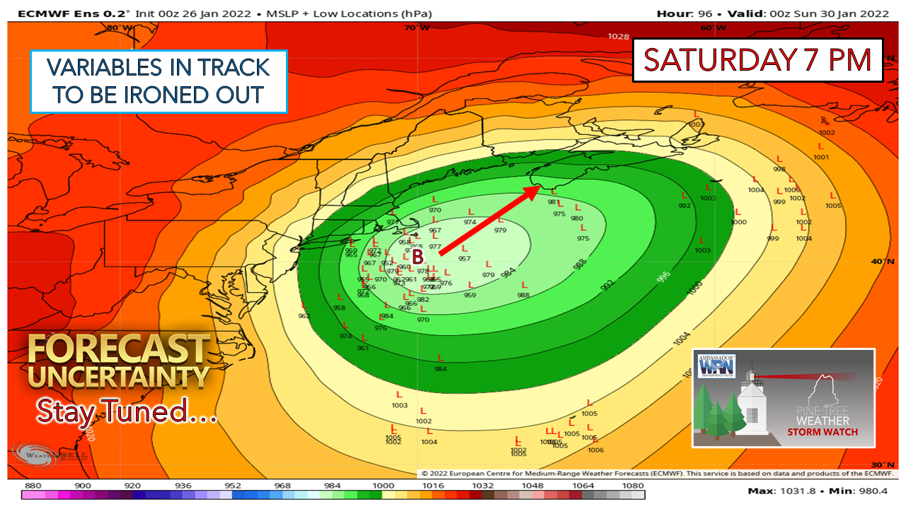 European ensemble ideas continue to show plenty of variables in track potential. The hint here is the track may shift further west as noted by the L's on the west side of the mean. This has been the trend in ensemble thinking over the past 24 hours. I suspect part of the variability comes in the form of convective feedback issues. 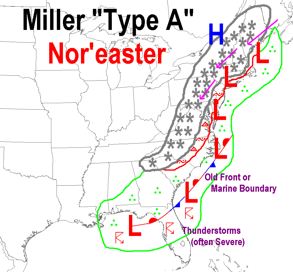 This is a classic "Miller A" NorEaster. With these kinds of storms, there is a tropical influence. When there is a tropical influence with cold air to the north, thunderstorms form on the warm front side of it. Guidance is anticipating that, thus struggles to account for the upstream impact of it, and if anything, typically over amplifies it. This is a known bias that impacts the data that models pump out. Some are better at handling it than others. This is why taking operational model ideas verbatim (ones often spread on social media, usually snow amount forecasts) are often wrong. Some models (*cough* Euro *cough*) are worse than others with it. The feedback issue does affect model ideas of track, intensity, and outcome. With a storm not likely to get its act together until Friday night, it will take that long for models to home in on a general agreement and potential outcome. For where we are at with time (Wednesday morning) and the storm (Saturday) there is a fair idea on overall impacts.  Thursday 7 PM to Sunday 7 PM - A general idea on timing and track with the European ensemble mean. The ideas being generated continue to point towards the nose of Nova Scotia westward to the Bay of Fundy. This isn't to say the storm could escape to the south and east of Nova Scotia, as that idea is possible given some operational model output. Taking the sum components of available data, this is fair estimate with track for now, subject to change. A more westward track brings the element of a mix and/or rain for DownEast areas, and heavier snow for the western mountains. A more easterly track favors a better chance for more snow DownEast, and less snow for the ski hills. 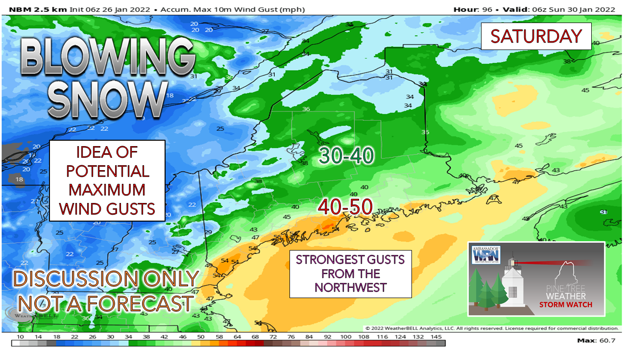 I teased on Twitter Tuesday afternoon about the "B" word and the fact that I would not commit to saying it. I am still not there with the idea of a textbook blizzard at this point. What I am confident about is snow is going to blow around. I am not so concerned with the northeast wind part of the storm for the coast, but the northwest wind on the backside as the storm moves away. If the model ideas of a sub-980mb storm are correct with a track as I presented in the loop before, a backside "ground blizzard" Saturday night as the storm moves away is on the table. The blowing and drifting of snow are likely for the coastal plain, along with whiteout conditions. Impacts from that are likely to exceed anything else the storm throws at us as of this point. The wind continues to blow into Sunday, although at reduced speeds, but it will be enough to continue the drifting and could make travel hazardous on the interstate and wide-open areas. 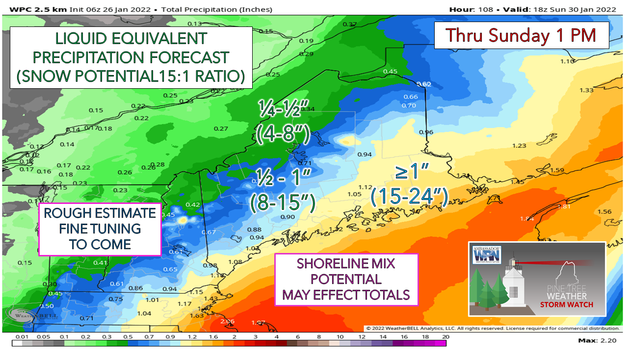 Based on the idea of the forecast track hitting Nova Scotia on the nose and the volume of cold air in the region, that brings the fluff factor into play. I will advise that these are likely not to be poofy flakes. With a very strong low-level jet below the snow growth zone (DGZ) I expect the snow to be grainy like the size of sand as it gets battered in its decent. Using the Weather Prediction Center estimate for liquid equivalent if one is to melt it down and factoring in the general idea on track gives me the basis for this rough estimate on snowfall amounts. The coastal plain can expect 1-2 feet at this juncture, highest amounts DownEast. Will a coastal front make an appearance and bring a mix and /or rain? It's totally possible. A more westward shift brings that idea closer to reality. 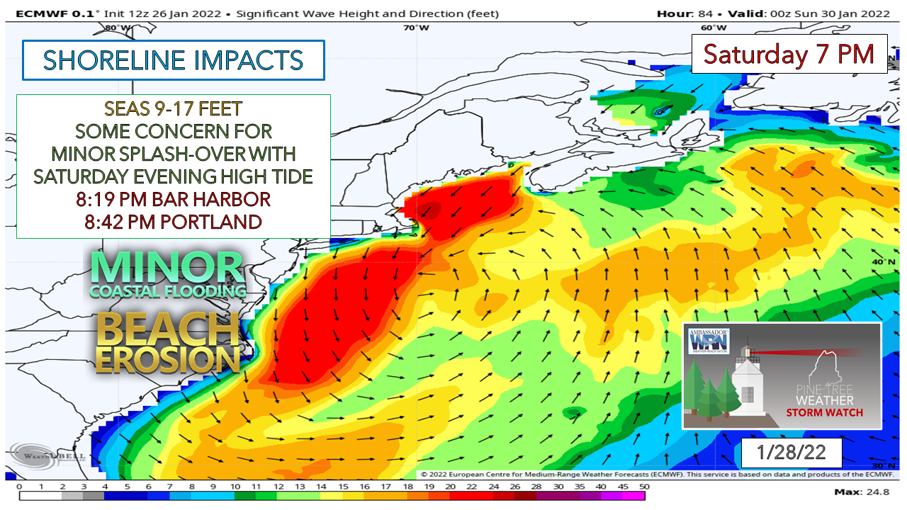 Timing of the storm at this point does the shorelines a favor. The Saturday morning high tide at 7:53 AM (Portland) is forecast to be 1½' higher (10.32') than the evening (8.82'). An estimated storm surge of 2-3 feet is possible, but the height of that appears to coincide in the afternoon as the tide is coming in. There could be some splash-over and beach erosion, but at this point not the kinds of issues seen recently. It's important to stay tuned for updatesThere are many moving parts to this storm and many questions to be answered. Please stay in touch with the National Weather Service and your local TV station of choice. For those following on Facebook, please see the pinned post on the page to get notified of the most up to date information from me. Twitter is where my "live blog" takes place. Links to those are below. My next planned update here is Thursday morning.  More about snow to water ratio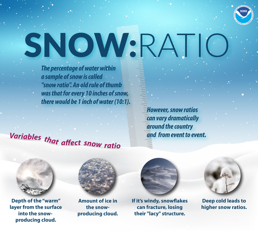 Be prepared to receive alerts and stay updated!
 For more information in between posts, please follow Pine Tree Weather on Facebook and Twitter. Thank you for supporting this community-based weather information source which operates by reader supported financial contributions. Thank you as always for your support! - Mike NOTE: The forecast information depicted on this platform is for general information purposes only for the public and is not designed or intended for commercial use. For those seeking pinpoint weather information for business operations should use a private sector source. For information about where to find commercial forecasters to assist your business, please message me and I will be happy to help you.
|

Mike Haggett
|