The coolest day this week will be on the first one…Monday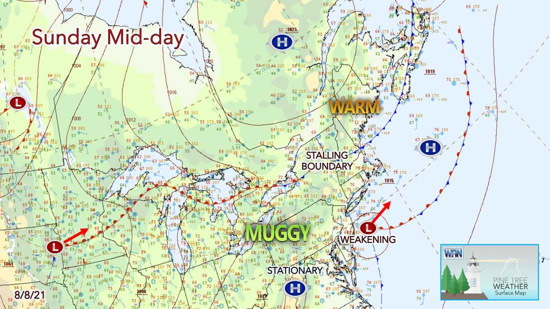 As the weak cold front begins to move out of our region, the forecast for Sunday night will be dominated by high pressure settling towards Nova Scotia. The gradient will support onshore flow over much of the area allowing for patchy fog to develop along the coastal regions. Humidity will remain high overnight as the muggy airmass continues to settle into the region. Minimum temperatures will be mild, with lows in the upper 50s to mid-60s across the state. Isolated rain showers and clouds will last overnight, but we should begin to clear and dry out by Monday morning. 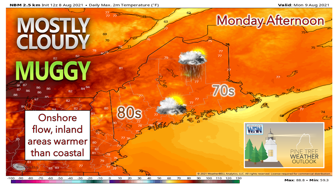 Muggy air from Downeast returns to Northern Maine as low-level southerly flow is present. Generally, expect mostly cloudy skies with a marine layer keeping temperatures from getting too warm. High temperatures will be in the mid to upper 70s with a few spots barely hitting the 80°F mark. Along the coast, high temperatures will only make it to right around 70°F. There is a chance for showers in the afternoon mainly far N/NW. The atmosphere is too stable for severe thunderstorm activity but heavy downpours and a rumble or two of thunder cannot be ruled out. Monday overall should be dry with a stray afternoon shower or storm possible. A mild and muggy night is expected for Monday, lows will only drop into the 60s statewide. There is another possibility of marine low clouds and fog towards Downeast, some fog may even spread north to Eastern Aroostook as we progress into Tuesday morning. Humid conditions increase each day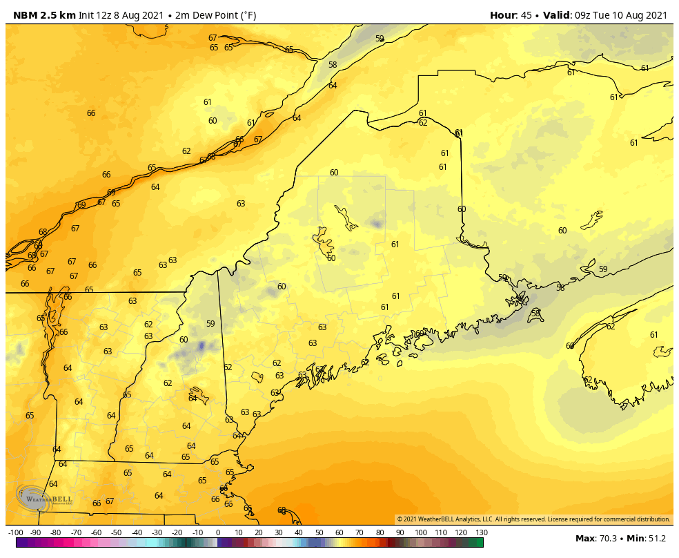 By Tuesday, a cut-off low lingering south of New England will continue weakening and finally move off the northeast coast Tuesday night into Wednesday. This will bring in the arrival of the heat and humidity into our region for the rest of the workweek. Dewpoints on Tuesday will creep into the low 70s with high temperatures reaching the mid to upper 80s, except in the mid to upper 70s along the coast. Tuesday night will be even warmer than Monday night with muggy conditions lasting. Lows only drop into the mid to upper 60s overnight. Then by Wednesday through the end of the week, ridging will build across the Northeast. Wednesday will be the first real warm day, with highs pushing to near 90°F across southern ME, and 80s elsewhere. Combined with rising dew points, heat indices from Tuesday to the end of the week will be well into the mid-90s. Make sure to stay updated with the forecast if you are planning on being outside most days! Shower and thunderstorm chances increase each day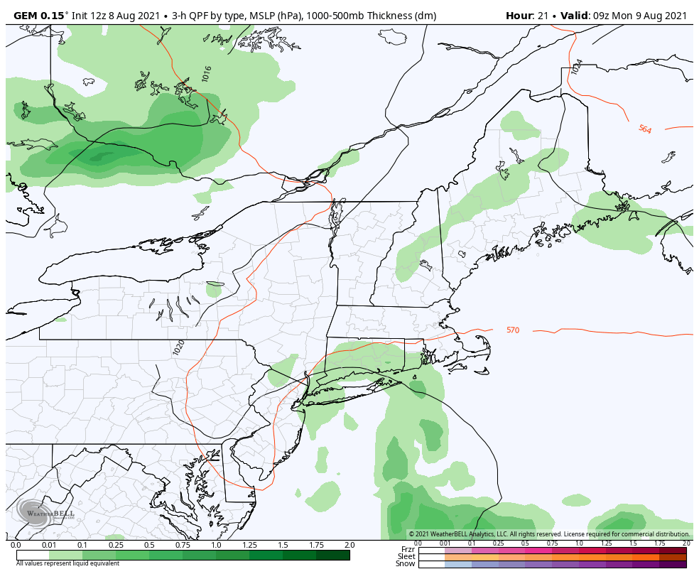 More widespread showers and thunderstorms are expected during the day on Monday, but most should remain dry. Any precipitation that does occur will be confined to the northern areas. A low that will be moving into the area on Tuesday will slightly delay the arrival of the heat during the day. This will also keep the chance for a few scattered showers, mainly inland before it pulls out of the area Tuesday night. Mainly afternoon showers and storms will persist through the middle of the week into Friday as an upper trough approaches from the west. There will be a pretty good amount of shower and storm activity Wed-Fri each day as the juicy air mass will remain in place. Models are picking up on a cold front passing through late Friday into Saturday, but we are still too far away to make any predictions on that. End of the week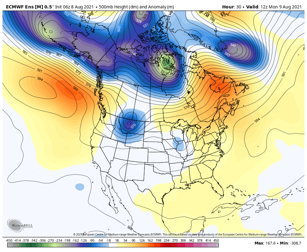 Most of the guidance agrees that upper-level ridging will consolidate from the Northwest U.S. into the Southern Plains during the extended range period, while upper troughing moves through the Upper Great Lakes and Northeast. Warmer than average temperatures and afternoon showers or storms will be the focus this week. Tropical activity will begin to pick up in the tropics along with temperatures rebounding to near normal over the weekend and to start the next workweek for Maine in mid-August. Camping Safety Going camping? Watch out for thunderstorms! Know your weather forecast and notify your family or friends of your plans. Have an evacuation plan and know where you can find shelter. Make sure to pack a safety kit and a radio for forecast updates. weather.gov/safety/thunderstorm Temperature outlook through mid-AugustThe plots below show the trend of the high and low temperatures for Carrabassett, Bangor, Caribou, and Portland over the next week and a half. Temperatures slowly increase as well as humidity to the end of the week. After a cold front moves in on Saturday, temperatures look to bounce back to average and will remain seasonable through mid-August. 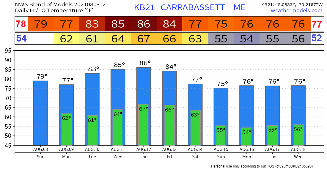 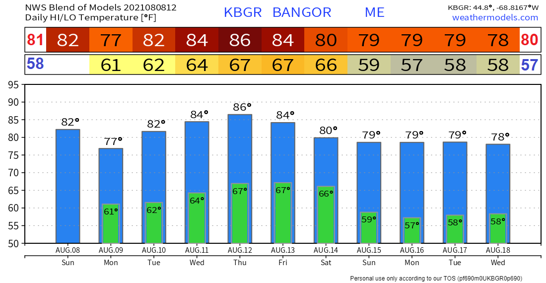 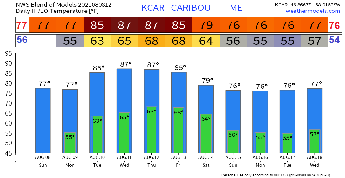 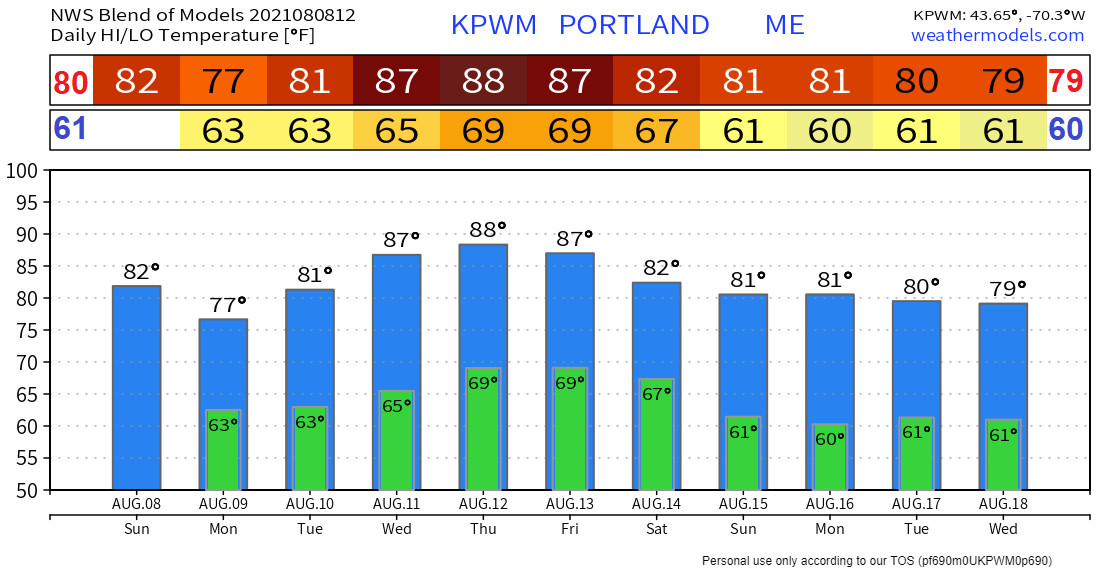 Be prepared to receive alerts and stay updated!
For more information in between posts, please follow Pine Tree Weather on Facebook and Twitter.
Thank you for supporting this community-based weather information source which operates by reader supported financial contributions. Stay updated, stay on alert, and stay safe! |

Mike Haggett
|