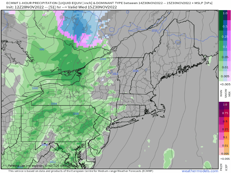
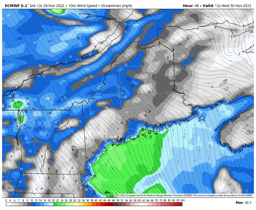
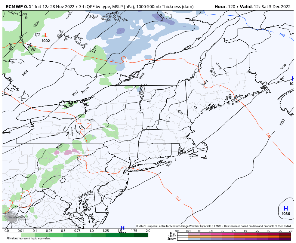
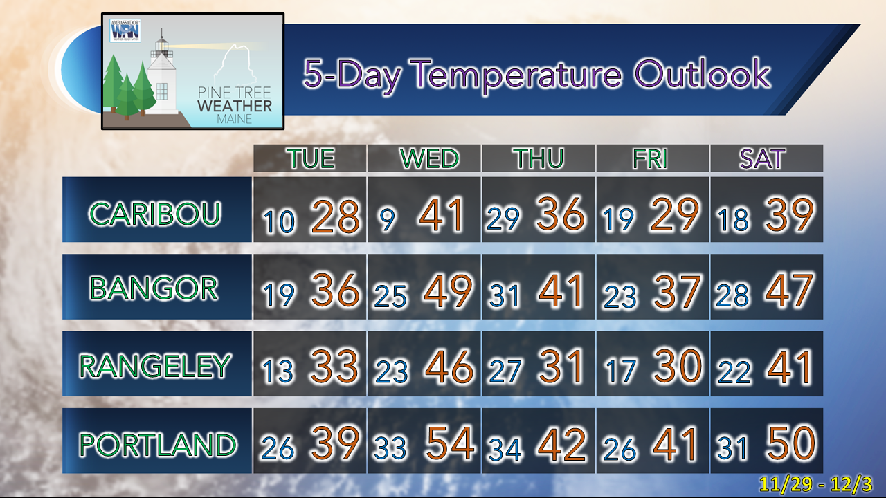
Pine Tree Weather
  • DISCUSSIONS
  • DONATE
  • MAPS
  • NWS BRIEFINGS
  • SATRAD
  • MARINE
  • SNOW / ICE OUTLOOK
  • RAIN OUTLOOK
  • CPC OUTLOOK
  • Kennebunk
  • OBSERVING WEATHER
  • Who We Are
  • My Photography
  • DISCUSSIONS
  • DONATE
  • MAPS
  • NWS BRIEFINGS
  • SATRAD
  • MARINE
  • SNOW / ICE OUTLOOK
  • RAIN OUTLOOK
  • CPC OUTLOOK
  • Kennebunk
  • OBSERVING WEATHER
  • Who We Are
  • My Photography

Inside runner storms Wednesday and Saturday

11/28/2022

Comments


Status update

Picture
Before I get into the forecast outlook, I want to say thank you to those who have sent along donations via VENMO, checks in the mail, as well as Patreon. I still have yet to hit 50% of what I need to pay the bills for 2023. The current deficit is about $1900 in order to cover expenses.

If you are new to what I do here, to this point, this operation runs solely on the contributions of those around the state and northeast who work, live, vacation, or have family here. I've been running on faith of funding from followers now for four years after footing the bills on my own for the first six. I wish I had time to fundraise through other means, but with a full time job, this, family, and life outside of that, I just don't have time to come up with gimmicks for money. Maybe that day will come, but for now, I need to work with the time I have and hope for the best. If you have yet to chip in, I would appreciate your help. 

Speaking of time, I will be away Friday through Sunday as my wife and I escape for a pre-holiday get away. We'll be going away for Christmas as well. Since we have no family left, we're investing in time away together with our grown daughters rather than gifts, as the memories last longer than the material things do. 

A rainy, windy Wednesday;
Icy morning commute concerns for Thursday

Picture
Wednesday 10 AM to Thursday 4 AM - Pardon me if you've seen this movie already this fall as it is about to happen again. In some ways the song "Inside Runner" on the phone has been stuck on repeat since October. Where recently low pressure would hang close enough to the St. Lawrence River valley to bring some snow or mix for the mountains and north, that does not appear to be the case this time. Fortunately this is shaping up to be a fast mover, but all areas will see liquid.

Wednesday morning appears dry for the morning commute. The statewide free car wash comes in time for the evening drive home. Rain could be heavy at times, with reduced visibility from that along with fog in areas that have a snow pack. There is potential for some localized flooding, especially in areas where the ground is frozen. Some urban street flooding is also possible from clogged drains, along with standing water resulting in a hydroplane risk on the faster roads. 
Picture
Wednesday 7 AM to Thursday 7 AM - Along with the rain comes a strong south/southeasterly wind that could bring the potential for flying debris and power outages. Wind gusts could reach 40-45 mph on the conservative end, with a risk of damaging gusts at higher speeds (50-60mph) as the frontal boundary passes through Wednesday evening. If the forecast ideas continue, I suspect that wind advisories are likely to be posted for the coastal counties. The timing of the wind could also cause problems for the evening commute, especially on the interstates.

ProTip: If you have Christmas decorations out, you'll want to make sure they are secure so that they stay in close proximity to your house, or else risk seeing them damaged or down the street on your neighbors lawn by Thursday morning. 

Also, for the shorelines... while we're coming off astronomically high tides from the new moon, I do have concerns with the high water mark late afternoon. With potentially the strongest wind gusts working through at the time of high tide, there could be some splash-over, beach erosion and minor flooding. 
Picture
Wednesday 7 PM to Thursday 7 AM -  If all of that isn't enough, there is the cold front that drags cold air into the state Wednesday night into Thursday morning. The above model idea from the GFS model in Celsius used on purpose here to see where much of the region freezes up (highlighted by the grays) by the time of the Thursday morning commute close to the shorelines. 
Picture
I will be right out front here and say that this idea from the national model blend is a bit on the conservative side for rainfall amounts as compared to individual ideas. What hurts the ski hills is the upslope enhancement of the southeast wind. One inch of rainfall is a fair bet at this point, but I wouldn't be surprised to see 1½-2" in spots, maybe isolated areas greater than 2" if the ideas hold up.

The ski hills are likely to benefit from upslope snow showers on Thursday as weak impulses work through, but only an inch or two of airborne fluff is expected out of that. 

Please help to keep PTW going into 2023

Picture

The next storm: Saturday

Picture
Saturday 7 AM to Sunday 7 AM - The next storm is similar to Wednesday's, but at this point does not appear as juicy with rainfall or as windy. In similar fashion, anything liquid appears to freeze up by Sunday morning, so if the timing holds up, there could be some slick spots around early on. Expect another breezy day to end the weekend with upslope snow showers possible in the mountains. 
Picture
Thank you as always for your support!

Stay updated, stay on alert, and stay safe!

- Mike

​NOTE: The forecast information depicted on this platform is for general information purposes only for the public and is not designed or intended for commercial use. For those seeking pinpoint weather information for business operations, you should use a private sector source. For information about where to find commercial forecasters to assist your business, please message me and I will be happy to help you.

Comments
    Picture

    Mike Haggett
    Kennebunk, ME

    Certified Weather
    Forecaster
    Penn State '21

    American Meteorological Society

    National Weather Association

    Weather-Ready Nation 
    Ambassador
    ​
    ​SKYWARN-CWOP

    Matthew 19:26


    Support
    Pine Tree Weather

    DONATE

    Picture

    Picture

    Picture

    Picture

    Picture

    Picture

    Picture

    Picture

    Picture

    Picture

    Archives

    January 2023
    December 2022
    November 2022
    October 2022
    September 2022
    August 2022
    July 2022
    June 2022
    May 2022
    April 2022
    March 2022
    February 2022
    January 2022
    December 2021
    November 2021
    October 2021
    September 2021
    August 2021
    July 2021
    June 2021
    May 2021
    April 2021
    March 2021
    February 2021
    January 2021
    December 2020
    November 2020
    October 2020
    September 2020
    August 2020
    July 2020
    June 2020
    May 2020
    April 2020
    March 2020
    February 2020
    January 2020
    December 2019
    November 2019
    October 2019
    September 2019
    August 2019
    July 2019
    June 2019
    May 2019
    April 2019
    March 2019
    February 2019
    January 2019
    December 2018
    November 2018
    October 2018
    September 2018
    August 2018
    July 2018
    June 2018
    May 2018
    April 2018
    March 2018
    February 2018
    January 2018
    December 2017
    November 2017
    October 2017

    RSS Feed

Proudly powered by Weebly