
|
First off, I hope everyone is enjoying a break from the heat. After 22 days straight of 80° or higher (28 days in the last 29 combined) it has been a record long warm spell. Checking over totals for the year, I've recorded 46 days of 80° or higher in Kennebunk, which is average to this point in the past two years. The grand total of 56 days has been the number for 2020 and 2021. I don't think we are quite done with heat just yet as there is still summer to come, and I will discuss that later in the post. On a personal note, I've slept very little over the past couple of nights and have a three-day weekend ahead where I have events planned, so the next full update may not come until Tuesday, but I will make an effort to post something here as time permits as the pattern is going to become more active. Keep watch on my Twitter account as well. As the trough goes...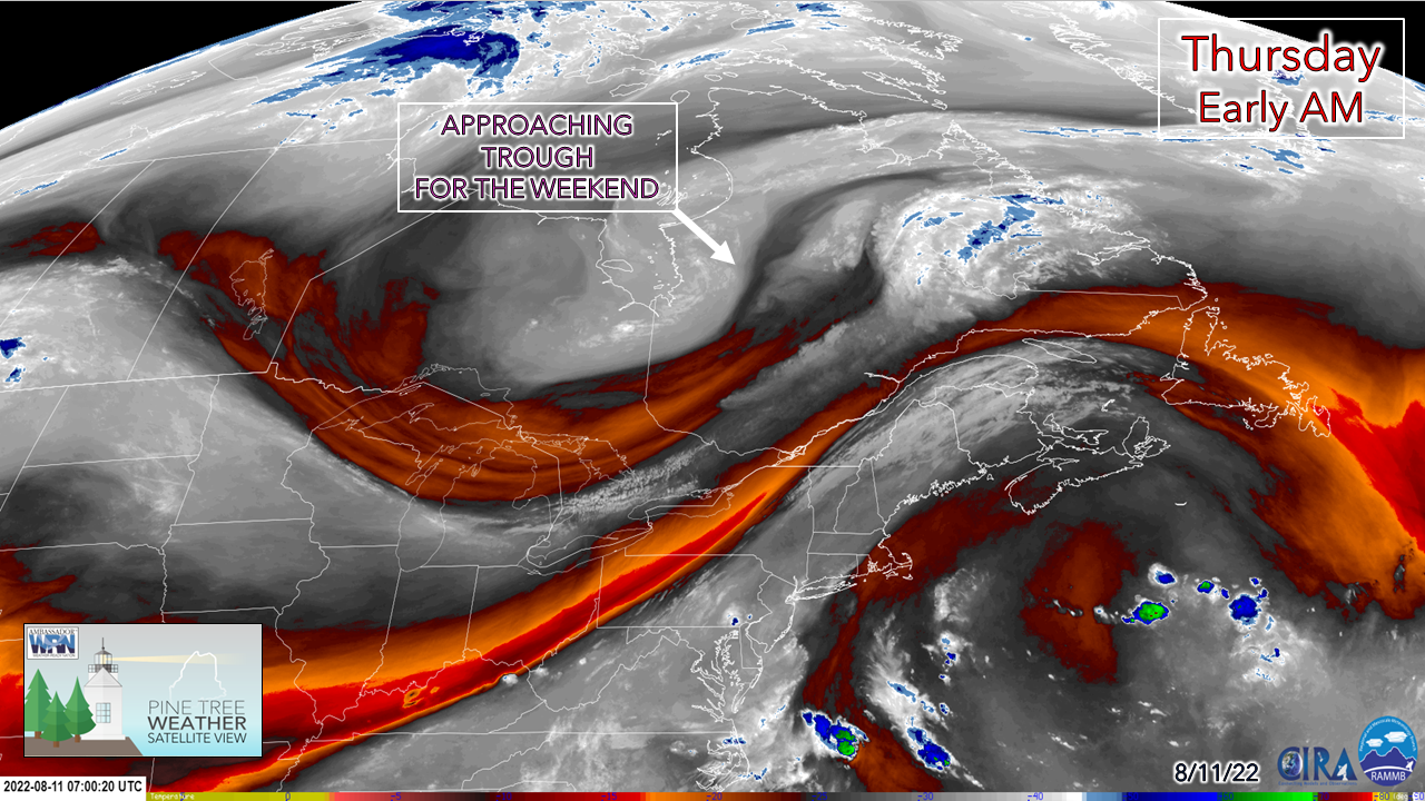 The majesty of the water vapor image shows the ridge out west building as a trough over Hudson Bay is digging to the southeast. You can see the double barrel cold fronts very clearly with the dry air pockets over the St. Lawrence River Valley and western Quebec. High pressure associated with the trough moves into the region Friday. As the trough digs deeper, and upper level sets up and adds intrigue and question marks as to how the second half of the weekend plays out. Few showers with a chance of a storm Thursday Thursday Noon to Friday 3 AM - The first cold front to pass through is the one that could pop up some isolated shower activity and a couple storms. Clouds will dictate storm potential as the parameters aren't great. A strong jet stream aloft ahead of the front keeps any building thunderstorm towers compressed as strong wind shear is likely to tear them to shreds. In this scenario, isolated low capped storms could bring a quick hit of rain, some gusty wind, with an outside chance of small hail. Severe chances are very low with the North Woods having the best chance to see storms potentially on the strong side before sunset. This is another potluck event, most areas stay dry, and the moose may have the best chance to share a story or two about anything that develops in the north. 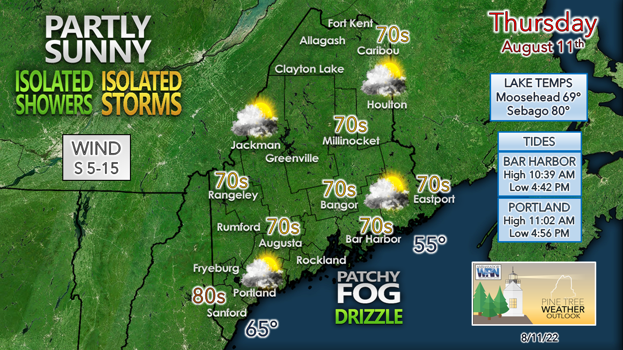 With the rise in dew points comes fog which could be locally dense and bring some drizzle along with it. Where the sun pokes out for a time is when temperatures shoot up. Most areas see 70s for highs, southwestern areas have the best chance to see 80s. The second front appears to pass through overnight. As high pressure works in, that increases the wind from the northwest which brings in dry and cool airmass with dewpoints around 50° and provide an early fall feel to Friday and into the weekend. Does the trough dig or not by Sunday is the questionThere is a bit of debate with model ideas that has been the off and on situation over the past couple of days that has brought the weekend forecast into question. It all has to do with the trough and associated upper-level low that sprouts off it. First scenario from the European model...  Friday 8 PM to Monday 8 AM - In this case the trough digs in over the MidAtlantic, turns sharply negative and spins up a surface low that could bring showers to the area for Sunday. This idea gives me the impression of an early fall NorEaster. If this scenario comes to fruition, it would give northern and eastern areas a decent sip or two of rain, scattered showers for much of western and central areas, and some breeze. While it would dampen any outdoor plans, any rain at this point for the coast is much needed and appreciated. To this point the European has been the outlier with this idea Then the second scenario, mutually agreed upon at this point by the Canadian GEM and GFS...  Friday 8 PM to Monday 8 AM - In this idea the trough does dig but not as sharply. Low pressure does form but stays out sea far enough that it might bring some light shower activity to eastern areas Sunday morning and that is about it. Clouds may be more prevalent over eastern areas regardless of if any rain gets squeezed out of them and makes it to the surface to start the day but would become progressively sunnier as the system moves into Cape Breton and beyond. One thing about me is I don't pick favorites with mid-range models, as by doing so, it is like playing Russian roulette. In this case here where there are sharp differences in potential outcome, I am not afraid to say that there are plenty of questions that still need answers before confidence is achieved. Stay tuned for more on how this plays out. The pattern into next week Monday 8 PM to Sunday 8 PM - When I see this loop of anomaly of the 500 mb steering level, I think cooler temperatures for next week, along with chances for rain. There is some discussion that the area could get a soaker given the pattern, and that is certainly a possibility, and would certainly be welcomed with open arms by many that are dealing with impacts of the drought. While I would love to jump on the roof and scream "DROUGHT BUSTER NEXT WEEK!" I know better than that. It's a week out at this point and given how desperate for rain that some folks are, to say that would be like Lucy laying the football down on Charlie Brown and then rip it away as he's about to kick it, leaving him hurt and mad if it doesn't happen. Is the idea out there? Sure. If some ideas that are out there play out, there could be potential for widespread rainfall that could bring flood concerns if the volume of water ends up ideas are spitting out ends up occurring. Bottom line, it is too early to go there. We'll see what happens as the trough settles in and then figure out storm potential at that point by the first of the week. Also. note the 594 dm area of high pressure over the Atlantic late in the loop. The rebound of the Bermuda High is something to watch as we head into the latter stages of the month for potential heat and tropical trouble. This pattern is going to get interesting and volatile from the looks as we head for fall. Stay tuned. Temperature outlook through TuesdayThe average high and low for Caribou for August 11th is 77° and 55°. For Portland, 80° and 61°. Temperatures are expected to be below normal on the high and slightly warmer on the low end overall into next week. 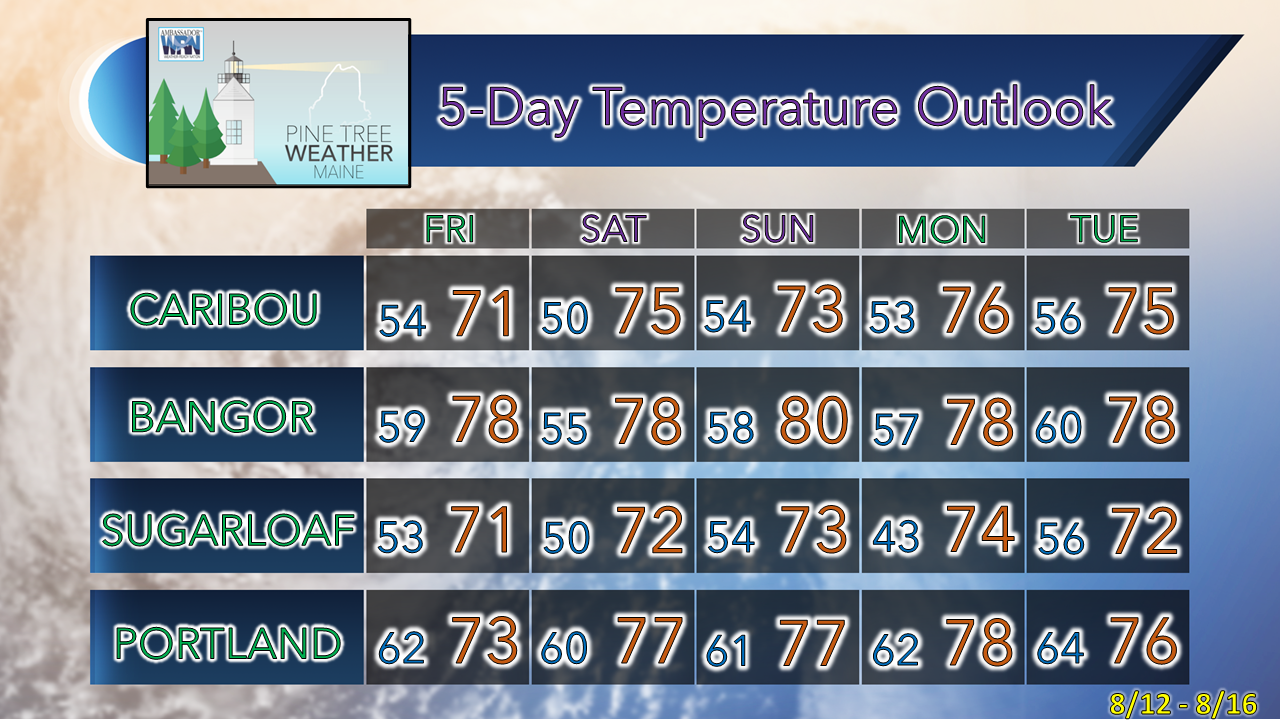 Thank you for supporting this community-based weather information source which operates by financial contributions from people like you. Stay updated, stay on alert, and stay safe! - Mike NOTE: The forecast information depicted on this platform is for general information purposes only for the public and is not designed or intended for commercial use. For those seeking pinpoint weather information for business operations, you should use a private sector source. For information about where to find commercial forecasters to assist your business, please message me and I will be happy to help you. |

Mike Haggett
|


