Pine Tree Weather
  • DISCUSSIONS
  • DONATE
  • MAPS
  • NWS BRIEFINGS
  • SATRAD
  • MARINE
  • SNOW / ICE OUTLOOK
  • RAIN OUTLOOK
  • CPC OUTLOOK
  • Kennebunk
  • OBSERVING WEATHER
  • Who We Are
  • My Photography
  • DISCUSSIONS
  • DONATE
  • MAPS
  • NWS BRIEFINGS
  • SATRAD
  • MARINE
  • SNOW / ICE OUTLOOK
  • RAIN OUTLOOK
  • CPC OUTLOOK
  • Kennebunk
  • OBSERVING WEATHER
  • Who We Are
  • My Photography

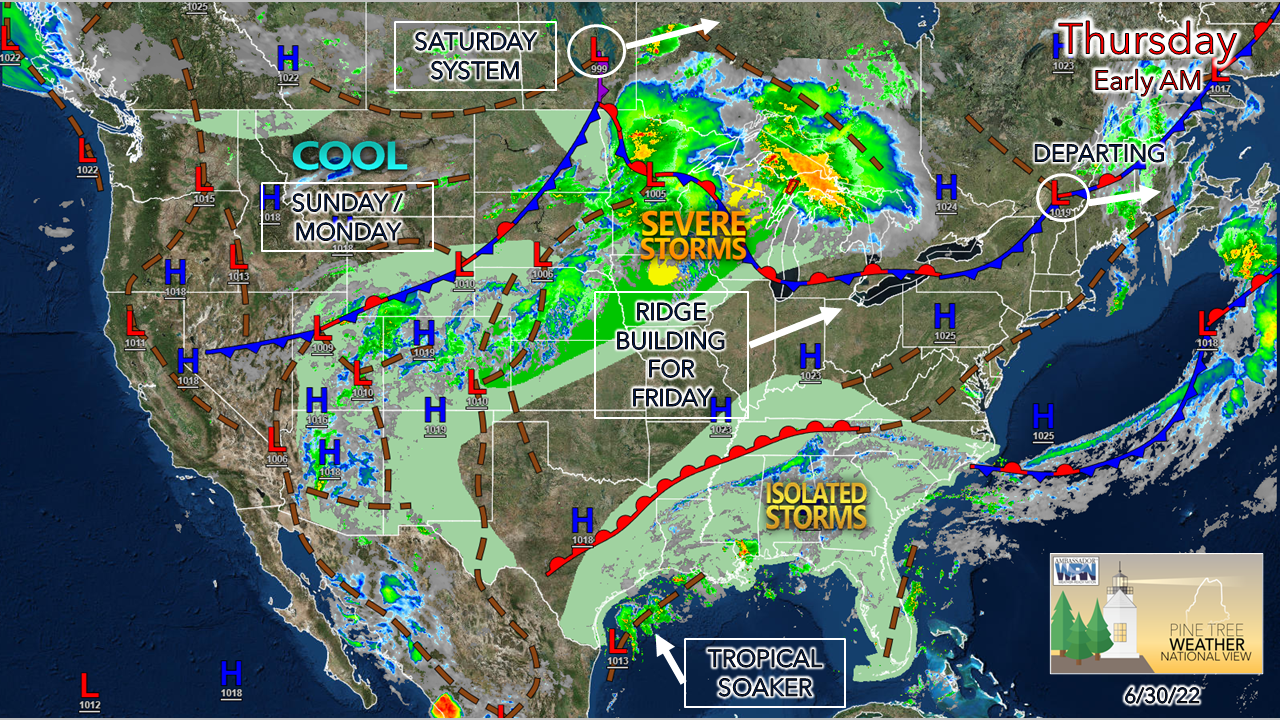
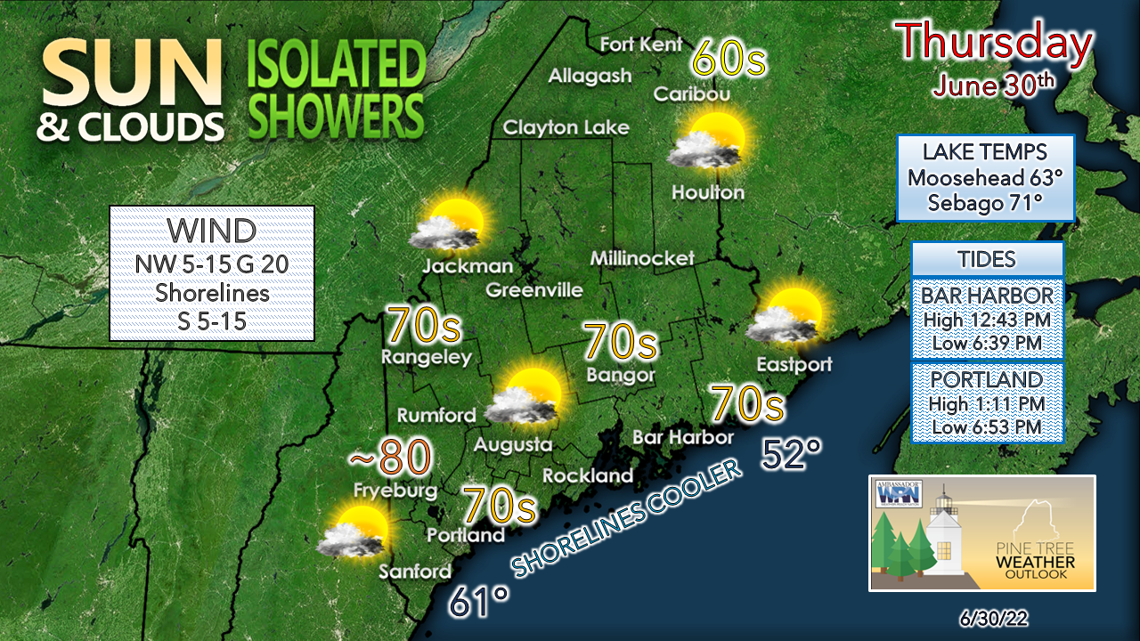
Isolated showers Thursday, showers and storms Friday night into Saturday; update for the Fourth

6/30/2022

Comments


Front departs, trailing wave may bring
​a shower Thursday

Picture
The month of June wraps up a bit on the cool side and generally fair for much of the region. A cold front passing through Maine early Thursday morning heads into New Brunswick. The ridge over the Midwest brings a warm front into the region Friday. After a quick hit of heat and humidity, a cold front passes through Saturday, bringing a shower and thunderstorm threat. An upper-low hangs around for the duration of the holiday weekend.
Picture
The best chance for a shower is over northern and eastern areas through the afternoon. I can't rule out a stray shower for the south and west which may pop up. The warmest temperatures for the day will be for the southwest interior where readings could reach the low 80s. Northern areas may make a run at 70° later in the day if the clouds clear long enough.

Clouds remain in the forecast overnight as warm air works in aloft, with isolated showers with a rumble of thunder possible for the mountains, north, and east overnight into Friday morning.  While temperatures are expected to be warm in the 80s (~90° for the southwest interior) dew point temperatures aren't expected to be oppressive but will be noticeable in the low-60s.

Frontal boundary passes through on Saturday

Picture
Friday 8 AM to Sunday 2 AM - There is still a fair amount of uncertainty about the timing of the cold front as ideas remain scattered. Showers and isolated thunder are possible Friday night into Saturday everywhere. As the front approaches, there could be a lull where the sky clears over the coastal plain, and if that idea happens, storms could fire up Saturday afternoon into early evening given the amount of humidity around.  The mountains and north may see the front slip to the southeast enough where the rain ends, and clouds break up heading mid to late afternoon.

For now, the best chance for severe storms is over southern New England. The main threat for Maine appears to be heavy rain and gusty wind associated with tropical downpours. Expect humidity levels to be oppressive on Saturday until dry air works in behind the front late Saturday afternoon into early Sunday morning.  

Outlook for the rest of the weekend

Picture
Saturday 8 PM to Tuesday 2 AM - A look at the forecast upper-level energy here indicates the pinwheeling of waves through the region as the trough aloft holds in place. How this translates to the sky and surface is the idea of sun and clouds, and if the wave is potent enough, a risk of a shower. While I believe that the coastal plain remains dry over the rest of the weekend, northern areas may deal with some widely scattered showers at times Sunday into Monday. If the upper low dips a bit further south, that may bring the risk of a shower further south. 

Temperatures are expected to be a bit cool but comfortable heading into next week. 
Picture

​Thank you for supporting this community-based weather information source which operates by financial contributions from people like you. 

Stay updated, stay on alert, and stay safe!

​Have a great day!

- Mike

​NOTE: The forecast information depicted on this platform is for general information purposes only for the public and is not designed or intended for commercial use. For those seeking pinpoint weather information for business operations, you should use a private sector source. For information about where to find commercial forecasters to assist your business, please message me and I will be happy to help you.

Comments
    Picture

    Mike Haggett
    Kennebunk, ME

    Certified Weather
    Forecaster
    Penn State '21

    American Meteorological Society

    National Weather Association

    Weather-Ready Nation 
    Ambassador
    ​
    ​SKYWARN-CWOP

    Matthew 19:26


    Support
    Pine Tree Weather

    DONATE

    Picture

    Picture

    Picture

    Picture

    Picture

    Picture

    Picture

    Picture

    Picture

    Picture

    Archives

    January 2023
    December 2022
    November 2022
    October 2022
    September 2022
    August 2022
    July 2022
    June 2022
    May 2022
    April 2022
    March 2022
    February 2022
    January 2022
    December 2021
    November 2021
    October 2021
    September 2021
    August 2021
    July 2021
    June 2021
    May 2021
    April 2021
    March 2021
    February 2021
    January 2021
    December 2020
    November 2020
    October 2020
    September 2020
    August 2020
    July 2020
    June 2020
    May 2020
    April 2020
    March 2020
    February 2020
    January 2020
    December 2019
    November 2019
    October 2019
    September 2019
    August 2019
    July 2019
    June 2019
    May 2019
    April 2019
    March 2019
    February 2019
    January 2019
    December 2018
    November 2018
    October 2018
    September 2018
    August 2018
    July 2018
    June 2018
    May 2018
    April 2018
    March 2018
    February 2018
    January 2018
    December 2017
    November 2017
    October 2017

    RSS Feed

Proudly powered by Weebly