
|
While looking at guidance Saturday afternoon I got to think of this Robin Williams classic where he plays Joey O'Brien, the brilliant used car salesmen in Cadillac Man. For those of you who have followed for a while, I mention that models act like a used car salesman, and that is what we have going on here. The forecast outlook is much different to the point of being weird. I remember a similar storm back years ago, forgetting the date, but remembering the situation. Once a high impact event with big snow with watches issued across much of the state, and it fizzled out to be a couple inches along the coast and big bust. What happened then that is similar now? The phasing of the northern stream with the southern one happened too late. The result was the storm came in flat and Nova Scotia got the goods. That is what is on track to happen here. Storm coming in further south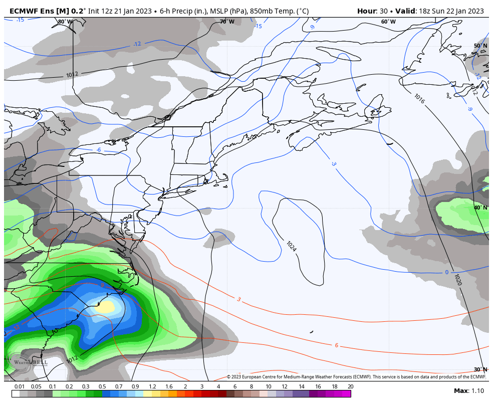 Sunday 1 PM to Tuesday 1 PM - In Friday's post I mentioned that the track was through the Cape Cod Canal and then punch Nova Scotia in the eye and would head into the Bay of Fundy. That has since changed. The track is more southerly, coming in right around benchmark 40° N / 70°W, stays out of the Gulf of Maine and brushes the eastern shore of The Land of Evangeline before going to Newfoundland. The ideas at this point have the phasing coming Monday night as the storm races off for the North Atlantic. The more southerly track and flatter system with a later phase has been the general theme with model runs over the past 72 hours. This was once a big dumper for the interior. Not anymore.  The bottom line here is with a more southerly track, this changes the outcome to a snowier affair. There is less moisture to contend with, as the heavier amounts are offshore. Another wrench in this is the high snow growth region. As the snow is falling, it will go through a mid-level jet stream that will minimize the size of the snowflakes as they reach terra firma. I do expect a higher snow to water ratio, in the vicinity of 15:1 over the mountains and between 10-12:1 at the coast. I'll do the math for you here and say that's ¼-¾" of liquid equivalent if it were rain. I am NOT confident that this snowfall forecast is going to hold up. With the speed of the storm increasing, the flat nature of it, the more southerly track, and the later phasing, these numbers could go down. I am not seeing any ideas where they are going up, other than the coast with the more southerly track, but that could drop there as well. Part of my thinking wanted to go much lower here, but there isn't enough data to support that theory as of yet. With a more southerly storm, it reduces coastal impacts and that is good news. The National Weather Service is thinking ½' of storm surge at this point, and that may go lower still. The coastal flood statements will continue for splash over and minor flooding for the high tides through midweek. It is incredibly frustrating as a forecaster within 24 hours of the start of the event to not have clear answers for you. I'd rather be honest and say that I am not sure than to spin up a forecast that has a particularly good chance that it will blow up. It's about integrity for me, and that it will always be. Stay tuned. Thank you as always for your support! You may not like the weather, but I hope you like what I do! Please hit the like button on Twitter and Facebook, and share! Financial donations to fund what I do are always appreciated! Stay updated, stay on alert, and stay safe! - Mike NOTE: The forecast information depicted on this platform is for general information purposes only for the public and is not designed or intended for commercial use. For those seeking pinpoint weather information for business operations, you should use a private sector source. For information about where to find commercial forecasters to assist your business, please message me and I will be happy to help you. |

Mike Haggett
|


