
|
PREFACE: If you have not read my previous update from yesterday posted on this very site, I would urge you to do so. Click on discussions and scroll down. Due to time concerns, I am not going to repeat everything. Everything in that post parlays into this one. Winter Storm Watch Posted Statewide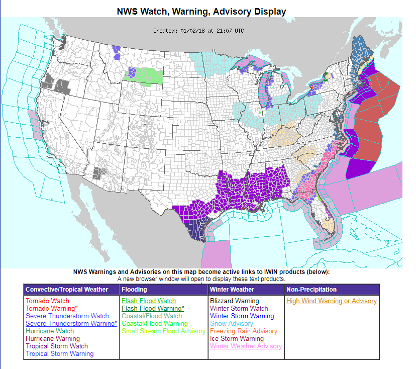 Expect the kitchen sink of warnings out the National Weather Service by the time this is over. Winter storm watches will likely turn into warnings. I suspect blizzard watches / warnings, coastal flood watches / warnings and high wind watches / warnings to come out of this before it is all over. Important to note: a hurricane wind watch has been posted for Georges Bank. It is VERY important that you stay in touch with the National Weather Service office in Gray and Caribou through this event. You can find them on the links page from the menu above. The latest on the track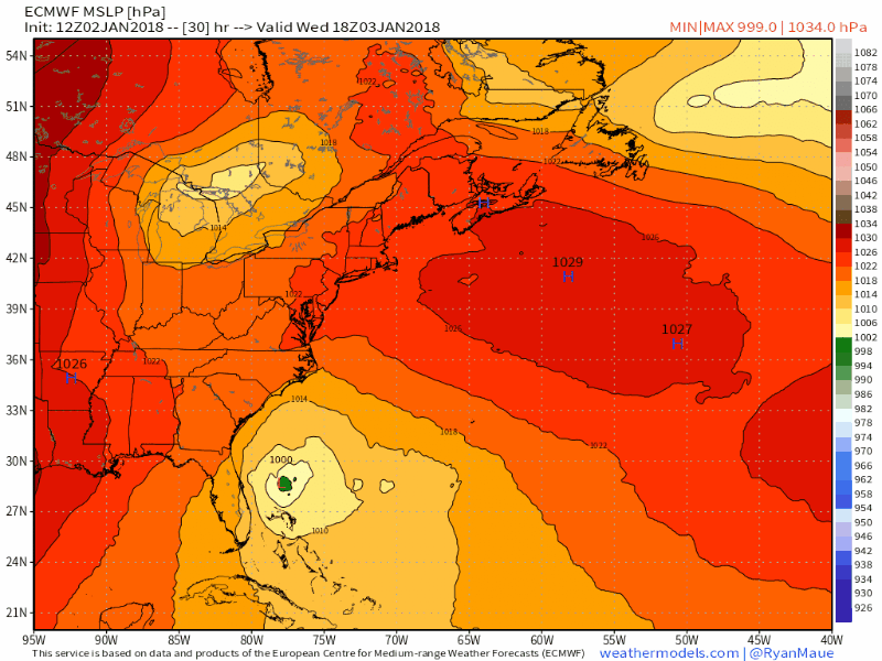 This gif image shows the birth of the storm Wednesday afternoon and its track up the eastern seaboard, in the eyes of the European (ECMWF) model. The storm develops rapidly as all the upper level pieces (the hose, driver, and kicker energy) come into line. The storm track has altered a bit to the west today. As I said in my earlier Facebook post, I don't think this will be totally figured out until Wednesday afternoon or Thursday morning. What is important here is this storm is a formidable one, no matter the track. Where typical NorEaster's bloom of the DelMarVa, this one births near the Bahamas. That gives the storm plenty of moisture from the Gulf of Mexico, plenty of time to strengthen, and travel to New England and Atlantic Canada. Then there is the wind...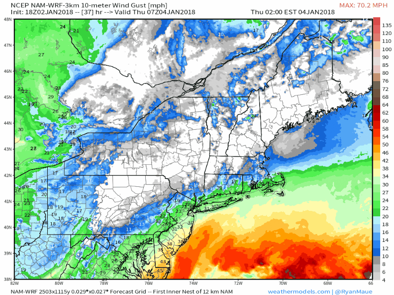 In looking over guidance today, the wind idea is perhaps the most important piece in this. Areas impacted with ice from the pre-Christmas storm do not want to see this. Gusts in the 40-50+ mph range Thursday could cause power outages for interior areas that have accretion. If you are in an area that has ice on trees, prepare to lose power. If you live along the shoreline and the coastal islands, it could get rather hairy with gusts in the 60+ mph range. I expect the offshore buoys will have a story to tell when this one is over. This wind is likely to bring blizzard / whiteout conditions for much of the state, which will make travel by Thursday afternoon a real problem. The strong winds begin to settle by Friday morning, but will remain an issue until the storm completely pulls away by Saturday morning. The ocean is likely to get ugly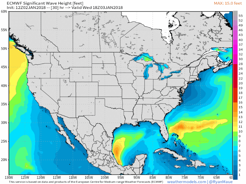 A big storm with Category 3 hurricane pressure causes big problems for the coastlines. With the ice that has formed in harbors in New England from the frigid cold, damage to docks, piers and vessels are very likely. Astronomical high tide with the addition of storm surge will cause flooding. Battering waves in the 20+ foot range will hammer the coast and cause moderate to heavy beach erosion. The ocean won't completely settle down until late Saturday night / early Sunday morning. And then there is the snow...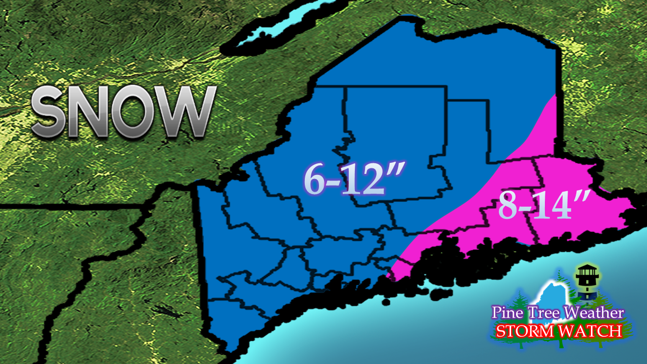 This is the first call, and subject to change. I mentioned 6-18" on my Facebook page Tuesday morning, and I do expect some places in eastern areas that could reach that. There is time for adjustment for track, but this is a good starting point. I expect fluff factor to play a role in this, given the deep cold in place. Given the strong wind involved, it may be easier to measure this one in drifts. It will likely be difficult to get accurate totals from this one.
The heaviest snow arrives Thursday afternoon into the evening and departs Friday morning. Snow showers will persist for much of the region well into Friday and Friday night. Blowing and drifting snow continues until the wind dies down by Saturday morning. The 5-Day Outlook page has been updated through the weekend. You can click menu to get you there. Prepare folks. This is quite a storm. - Mike |

Mike Haggett
|


