
Mainly dry but breezy until Tuesday Outside of a brief shower over southwestern areas and some spotty flurries in the north country roughly around daybreak on Sunday, that will be about it for precipitation until after the work week gets underway. Any clouds around will break up over southern areas as the morning progresses. Clouds appear to be a bit more abundant in the north as low pressure moves eastward. It will be cooler and breezier. I can't exactly call for a "Flying Trash Can Alert" since it is Sunday where there is no garbage pick up, so I will go with a "Leaf Blowing Advisory" instead. Folks who put their trash out for Monday pick up should opt for early morning curbside placement, unless you'd rather spend your time cleaning up the mess in addition to your typical before work routine. Folks can keep that idea in mind for every morning this week from the looks. A Manitoba Mauler or Mutter for Midweek?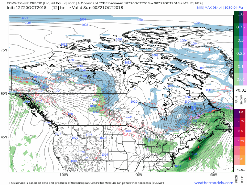 As mentioned in last night's update, we're tracking a piece of energy from Alaska / Yukon area that will travel into the Northwest Territories and head southeastward toward New England. A hat tip to the fine folks at the NWS Gray weather office in their Area Forecast Discussion Saturday afternoon highlighting the difficulty in forecasting the potential with the Tuesday / Wednesday system: " U.S. models have always had a history of poor performance with these short waves moving thru those data sparse areas of Canada where EURO has performed well. Ole rule of thumb also dictates potential significant closed upper low development along northeast corridor 72-96 hrs after movement into the 110W area with rapid height rises. With that said, EURO preferred model and shows an outcome scenario that one would expect as it continues to hint at the scenario of coastal development late Tue into Wed. It would be a fools errand to try and predict outcome at this point, but will begin nudging and hedging forecast to EURO solution by increasing POPs and avoid flip flopping of forecast for Tue into Wed time frame." The short interpretation of this is that it is too early to tell on precipitation amounts, types, timing or much else at this point. It may be Sunday afternoon or Monday morning before a clearer idea develops once the energy descends south enough for radiosondes to sample it. For now, I am sticking to the idea of snow/mix for the mountains and north, with showers for the coastal plain. This is subject to change, so stay tuned.. Outlook through Thursday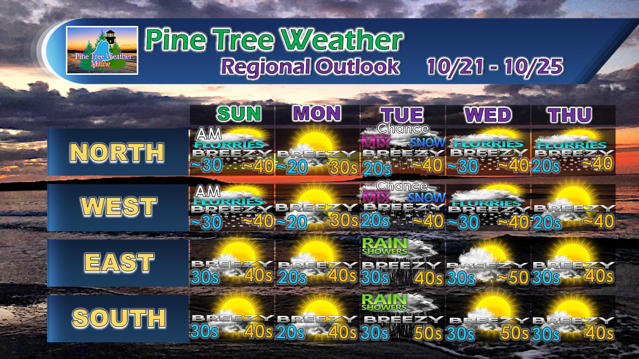 I will update on the midweek event Sunday afternoon.
For the latest official forecasts, bulletins and advisories, please check in with the National Weather Service in Gray for western and southern areas, or Caribou for northern and eastern parts of Maine. For more information from me, please follow the Pine Tree Weather Facebook page and my Twitter feed. Thanks as always for your support! Please consider making a donation to keep Pine Tree Weather going through the year ahead. Check out the donate page on how to contribute. Always stay weather aware! - Mike |

Mike Haggett
|


