
The set up, and recent history to go with it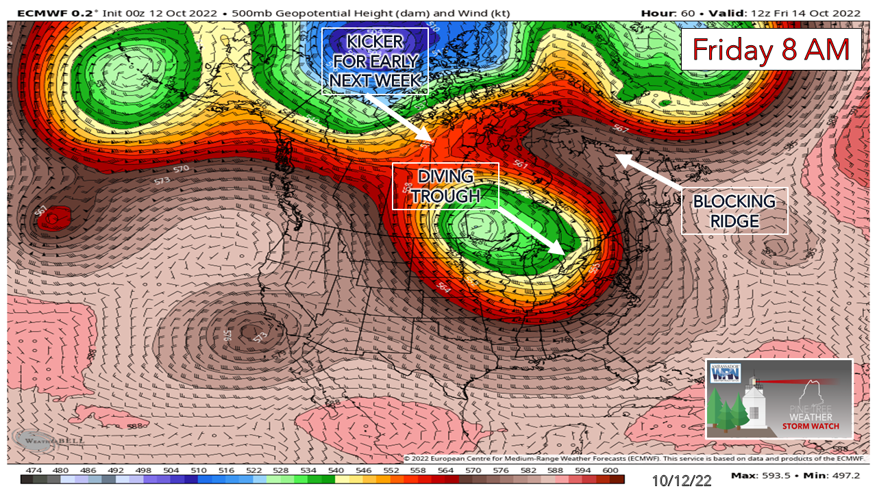 Guidance has been struggling to come to some sort of reasonable agreement on how this storm plays out, and in the eyes of this forecaster it has much to do with the strength and impact of the blocking ridge that is setting up to the northeast over eastern Canada along with how deep and strong the trough comes in behind it. Now that ideas have come to a better consensus, the forecast is coming into focus. I field questions and comments at times from followers when storms of some level of significance pop up. In this case, "Why is this happening so early?" appears to be a common question. I decided to dig into some recent history to see where this lines up. Take a good look at the forecast 500mb steering level chart above, and note the ridge and trough set up. 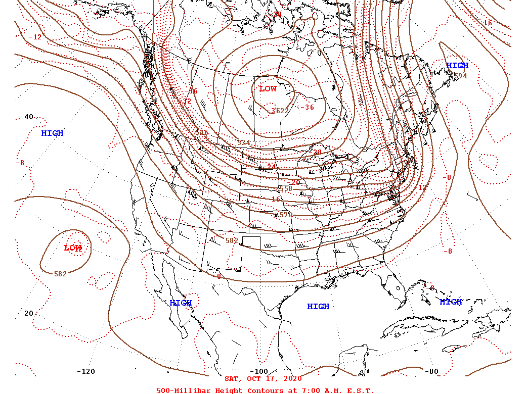 The date is October 17, 2020, a comparable situation with a strong blocking ridge over eastern Canada and a trough diving southeast from the Canadian Prairies, with moisture streaming in from the south. The surface map set up that day... 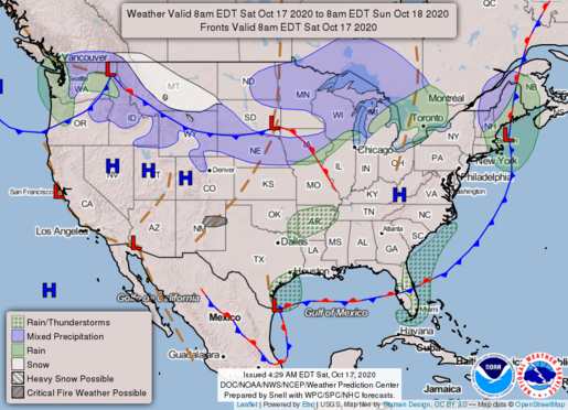 I discussed this storm topically on October 15th before I left town for that weekend. It was a decent storm for the region. The western mountains and northern New Hampshire picked up as much as 9" of snow and the rain totals of 1-3" were consistent over western and southern areas as well as eastern and northern areas. While snow is not on the table with this event, some flakes may fly in the mountains early next week. More on that in a bit. The bottom line here is these types of storms in mid-October aren't out of the realm of possibility. A quiet Wednesday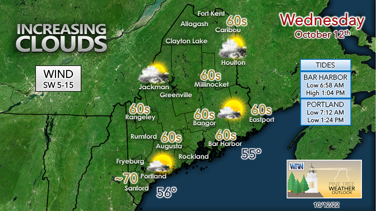 Any fog around early burns off and sun will be the main sky feature until high clouds begin to roll in from the west as the ridge builds in. A bit of breeze pumps warmer air in for above average temperature day for much of the region. Clouds begin to thicken, and all areas appear cloudy or some partial sun around to start Thursday. Heavy rain is the main concern with this stormThe Weather Prediction Center has had this set up pegged all week. I mentioned here previously with my update Sunday that they had it noted in their 5-day outlook. For those following me on Twitter saw my auto feed from WPC kick in on Tuesday. A soaker is in the offing here. 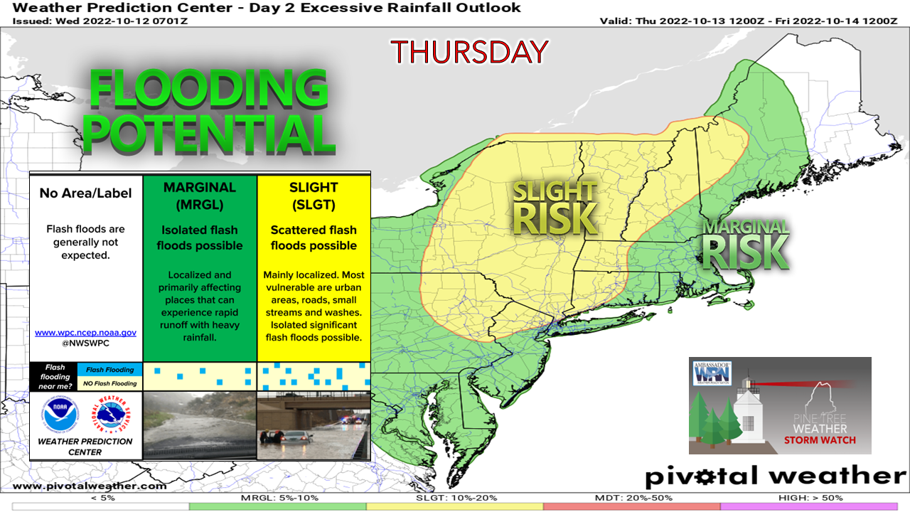 Important to note here that WPC's window is between 12z (8 AM) Thursday to 12z (8 AM) Friday. Much of rain that comes in this part of their forecast comes to Maine Thursday night. 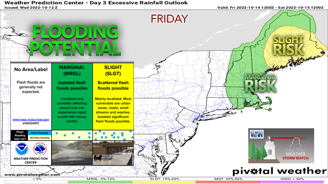 From 12z (8 AM) Friday to 12z (8 AM) Saturday, the heavy rain threat moves eastward over central and eastern areas. 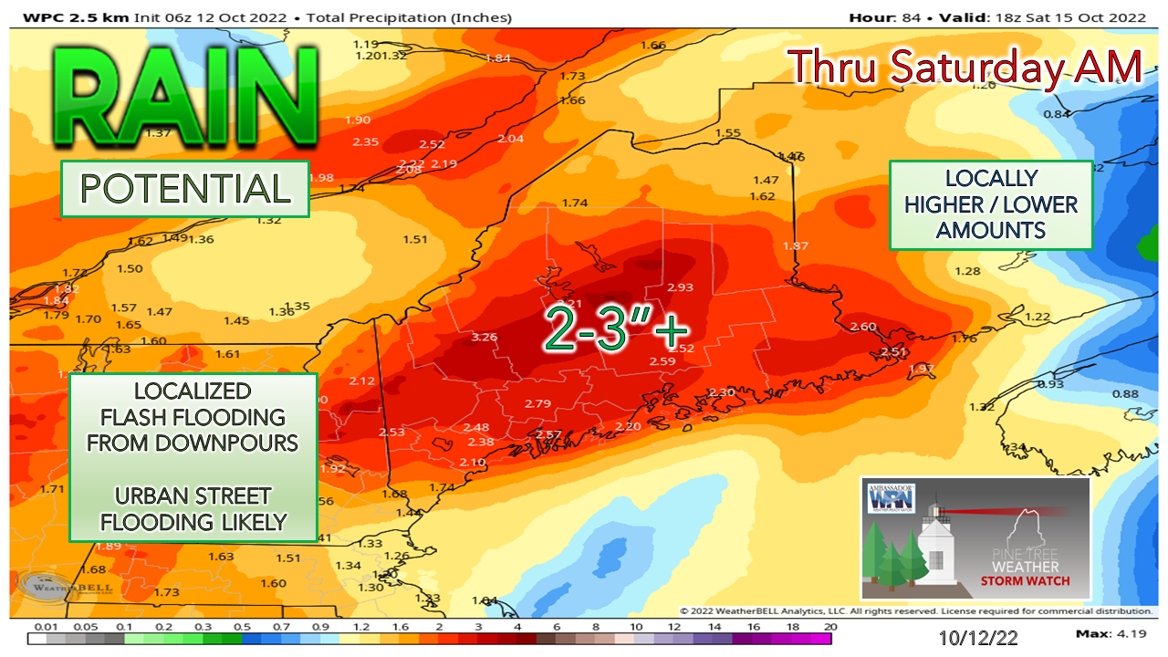 I've seen some ideas push totals upwards of 4-5" in spots between the western mountains and eastern areas. With the atmospheric river stretching all the way to where Tropical Storm Karl is located in the Bay of Campeche, there may be some convective feedback inflating the projected tallies with the European model. Regardless, there is a lot of juice associated with this. Localized flash flooding is the main threat here with the tropical influence. With falling leaves, storm drains are likely to clog up and turn some city streets into rivers. Of note, October is the wettest month of the year in Portland (5.25" on average) and the second wettest in Caribou (3.99"). Some areas may see what they get in a month with this storm or get close to the monthly average with half the month still to go. In regard to timing, there is still some play here. Showers are on track to start over western areas Thursday afternoon and spread south and east Thursday night. Western and southern areas are expected to see rain taper off Friday afternoon. For northern and eastern areas, rain may continue into Saturday. Expect a better idea on this to come. Some wind around to bring the leaves down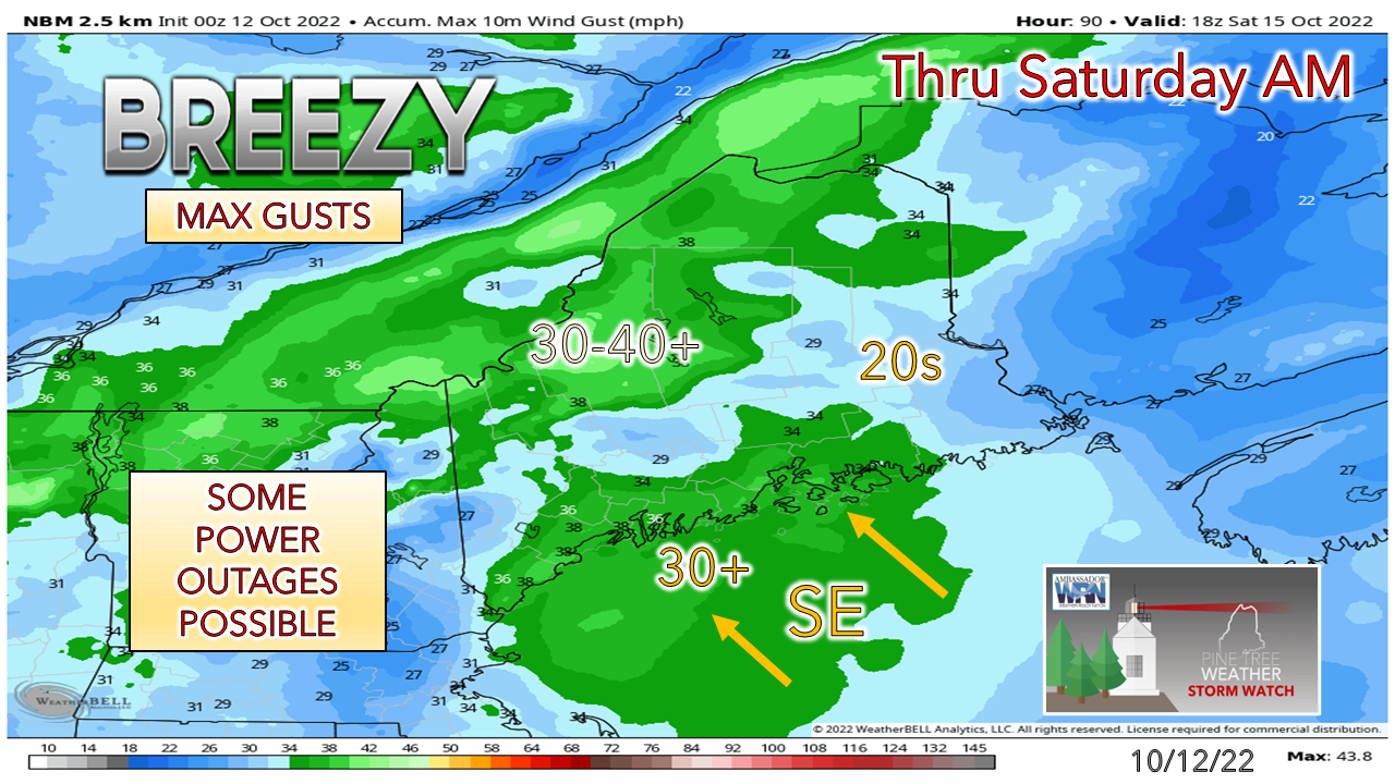 While the low-level jet could produce wind speeds to 50-60 knots, an inversion appears to keep the strongest gusts aloft, outside of any downpours that may drag faster speeds to the surface with it. Southeast wind flow and heavy rain is usually not a good combination for an area that has a tree root system geared for south to northeast direction. While earlier thinking considered a potential wind advisory, it may not get to that level, but expect the breeze to be strong enough to strip leaves and pine needles off trees, bring down some limbs and cause some power outages through Friday evening. With wet leaves on paved roads comes the risk of slick travel conditions. Think of snow as you travel around until the region dries out on Saturday. Pattern outlook into next week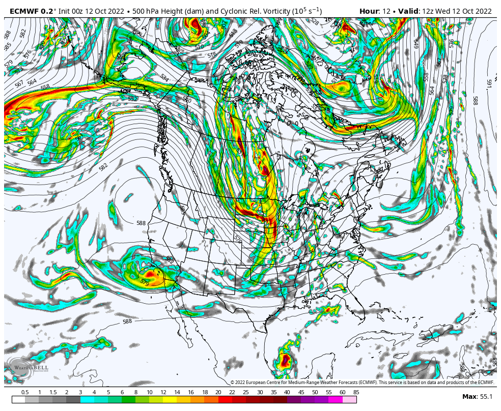 Looking here at the 500mb steering level forecast and putting it into motion for the next week indicates the upper low feature behind the frontal boundary that brings rain to the region through Saturday gets caught up in a bit of a traffic jam with ridge to the northeast. A gyre (large trough) develops Sunday and hangs around until a kicker from the Arctic comes down and gains atmospheric supremacy and moves it out of the area.  Putting that in the context of the surface map over the same time period, the kicker drags down a shot of cold air, which along with the energy spinning round from the gyre may bring some snow to the mountains and north next week. It won't stay cold enough to stay on the ground, but cooler than normal temperatures are expected the second half of next week. The pattern is about to get busy. Temperature outlook through MondayThe normal high and low for Caribou for October 12th is 55° and 37°. For Portland, 61° and 42°. Temperatures are expected to be above normal overall into early next week. 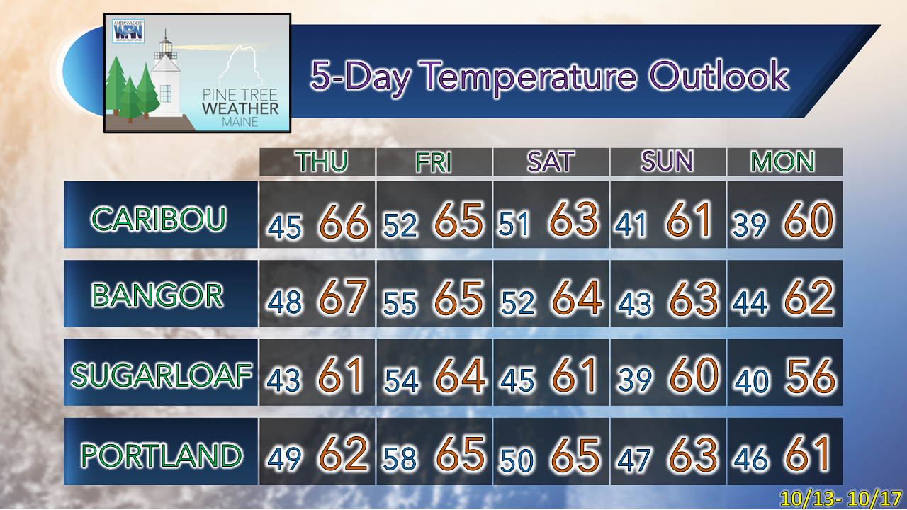 |

Mike Haggett
|


