
|
I am back in the saddle here after a break thanks to reaggravated case of rheumatoid arthritis in my thumb knuckles, which I deal with at times and have since 2003. They are still a bit tender, so I will take it easy, and to my best to stay on point. Thanks to those who commented support and therapy ideas on Facebook. I know I have the best followers on the planet, and I am grateful to each of you. Pardon me if this looks familiar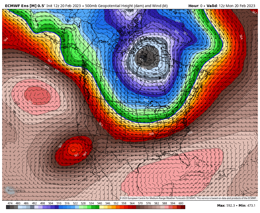 This is the outlook for the week of the 500mb (~20,000' altimeter) steering level of the atmosphere with heights shows the deep cold over Hudson Bay and a strong southeast ridge building to keep it contained there. The upper-level low responsible for that cold spawns cut-off upper-level lows over the southwest. They pop out and then get reeled back in as the ridge tells them to go back home. The blue line as that is a clear indicator for the cold, which as you can see will venture further south as we head into the weekend. The other piece here is those cut-off upper lows over the southwest. The one late in the loop (Saturday) may help spark a potential NorEaster next week. As far as the familiarity factor, that deep gray cold over Hudson Bay is what we dealt with earlier in the month. We'll need to keep an eye on that. A bit of snow Tuesday evening for some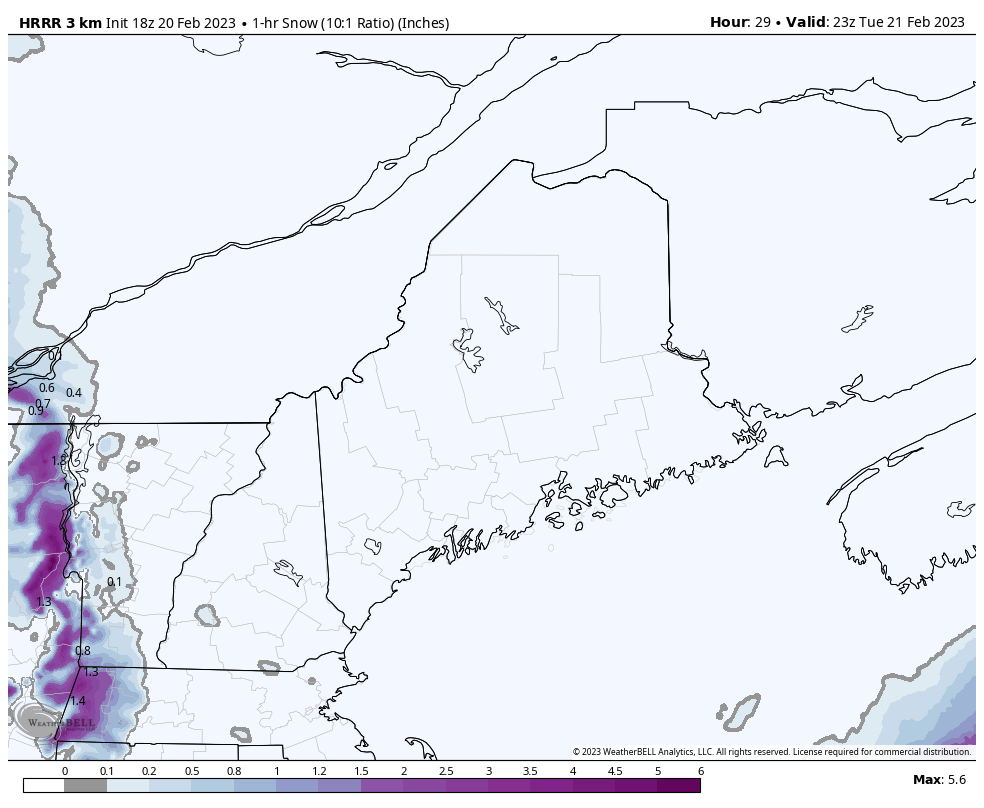 Tuesday 6 PM to Wednesday 4 AM - A one hour look at snowfall amounts shows a nice, juicy clipper that passes through western New England and then runs out of gas by the time it gets to Maine. This is expected to be nuisance, more than anything else. Models have been overly juiced with this one, and the time gets closer, they are reeling back their ideas. What was a solid 1-3" over southwestern areas may bring an inch or two, with a few isolated areas of 3-4" maybe, but this to me has bust written all over it. Eastern and northern areas may get a few flakes, but nothing impactful. Southern areas and the mountains have the best chance, and will likely have to run the salt trucks out, but that may be it. Get the leaf blower out for this one and make short order of the clean up. Expect a few slick spots for the overnight ride in areas, and on the roads less traveled Wednesday morning over southern and western areas. Yes, storm likely Thursday into Friday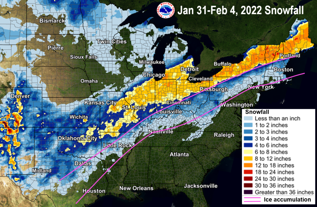 Since NWS Gray brought this up in their discussion early Monday morning in comparing what is potentially coming late week, I went in and dug this out since there is a pseudo-similar track to this. The outcome, however, may be different as far as who gets how much. 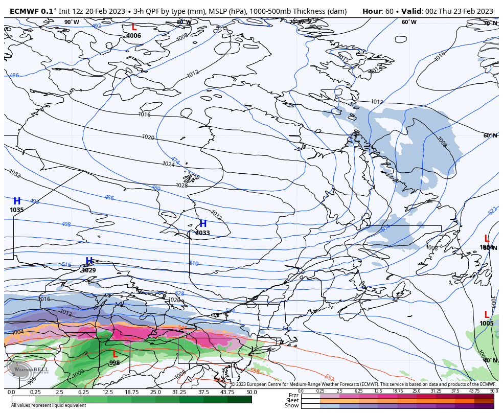 Wednesday 7 PM to Friday 7 PM - If you look at the snowfall map above and see the idea the European model is trying to sell here, it is easy to see similarities in track. Strong area of high pressure to the north locks in the cold and a warm front tries punch into it, but ends up losing the battle. The result of the losing boxing match means snow as potentially the dominant precipitation type for all but the far south as it appears for now. It may be all snow if recent model ideas with a more southerly trend. Pardon me as I chuckle because as I have stated so many times on this site over the years, models don't handle cold well, so the more southerly track is hardly a surprise. Once the warm front gets shutdown and pushed off to the east, an area of low pressure passes through the area Thursday night into Friday. For those curious about the shorelines, we're at the highest of the new moon phase tides today and those will drop as the week progresses. For now, I am not expecting too many issues, if any. 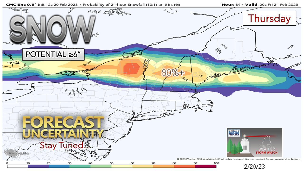 On the front end of this, southern areas have a good chance of 6-12", with most areas will need to plow / and or shovel some amount. Travel could be a pain as the snow will go on through the morning, take a bit of a break, then return as the trailing low comes through. 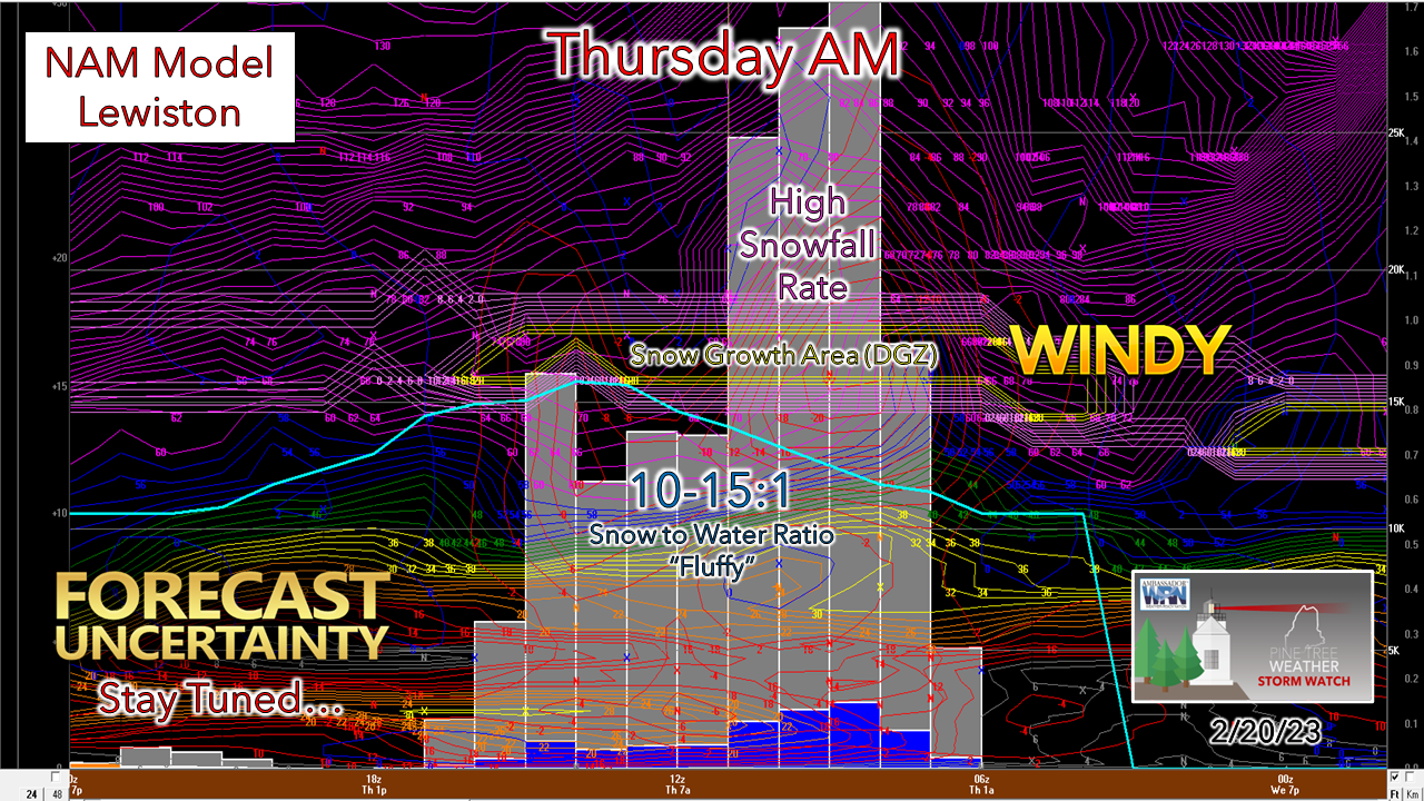 Digging under the hood here a bit with the Bufkit profile for Lewiston shows snow holding off until around midnight Thursday, then has the potential to dump for a few hours before sunrise. It's pretty windy in the snow growth region around 17,000 to 15,000 feet above ground as the model idea depicts, but as it makes it's freefall, the idea for now is that it should hold some decent structure as it makes landfall. Some decent fluff factor here with the higher ratio, which would make it easy to move and push snow amounts higher as a result.  Looking at the potential outcome of the parting gift Thursday night into Friday shows potential for another 6-10" for the ski hills considering the higher ratio. Eastern areas may get into the 6"-ish range as well. Just remember... the trend, for now, is moving south. High pressure to the north is cold and bone dry. There is some play involved here in this outcome, and still many questions to be answered. Expect to shovel, and expect to it more than once. Also, expect travel to be dicey both Thursday and Friday.  Temperatures through SaturdayA Long John Index of four by the weekend. I am not expecting freezer burn wind chill at this point, so while it will be cold, it may be tolerable given the fact wind is expected to be light. Saturday appears dry for now, with potential for snow showers on Sunday from a potential inverted trough set up. 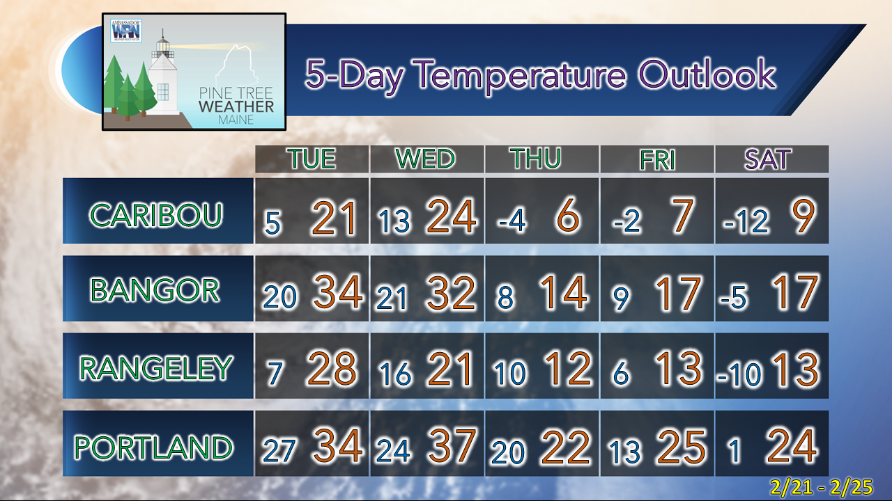 Thank you as always for your support! You may not like the weather, but I hope you like what I do! Please hit the like button on Twitter and Facebook, and share! Financial donations to fund what I do are always appreciated! Stay updated, stay on alert, and stay safe! - Mike NOTE: The forecast information depicted on this platform is for general information purposes only for the public and is not designed or intended for commercial use. For those seeking pinpoint weather information for business operations, you should use a private sector source. For information about where to find commercial forecasters to assist your business, please message me and I will be happy to help you |

Mike Haggett
|


