Pine Tree Weather
  • DISCUSSIONS
  • Substack
  • WEATHER WALL
  • MARINE
  • CPC OUTLOOK
  • Kennebunk
  • INTERNSHIPS
  • MY BIO
  • PTW IN MEDIA
  • INTERN ALUMNI
  • DISCUSSIONS
  • Substack
  • WEATHER WALL
  • MARINE
  • CPC OUTLOOK
  • Kennebunk
  • INTERNSHIPS
  • MY BIO
  • PTW IN MEDIA
  • INTERN ALUMNI

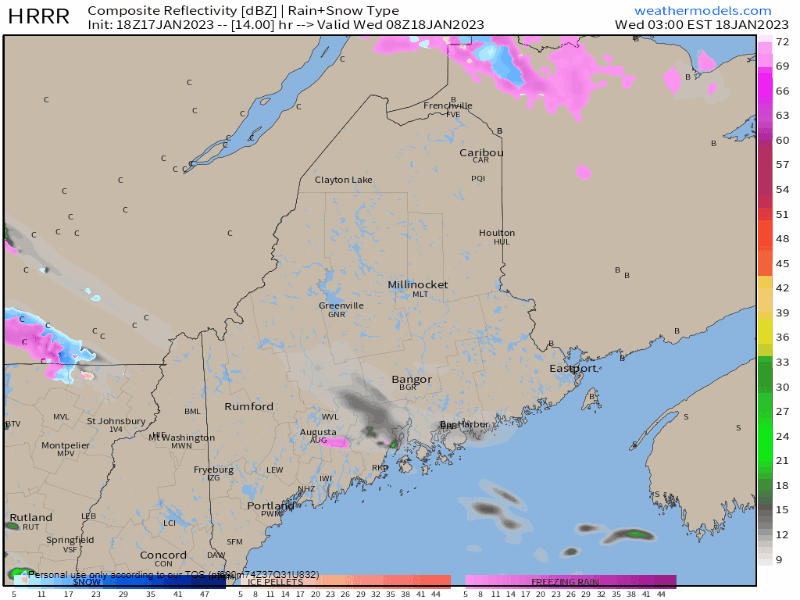
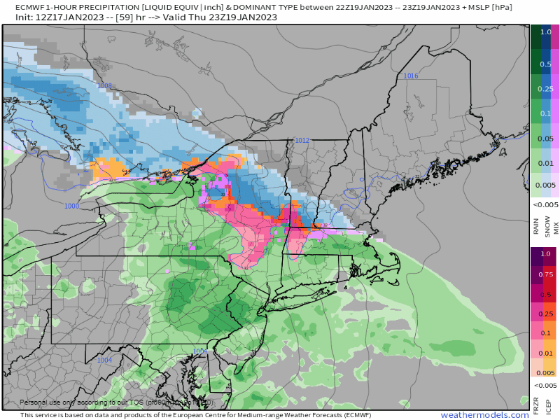
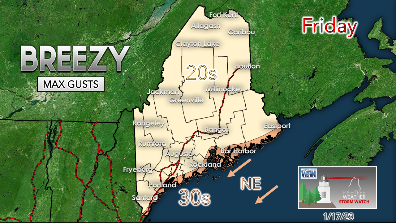
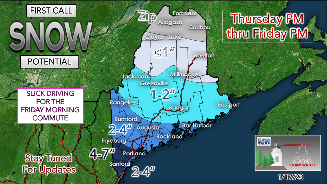
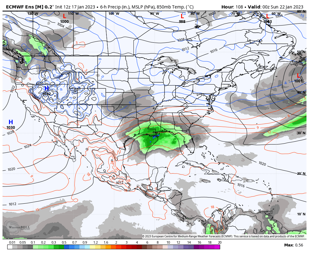
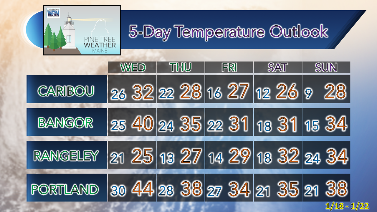
Light snow for the north Wednesday, a decent snow for the south Thursday night into Friday

1/17/2023

Comments


A break from the junk storms... for now

Picture
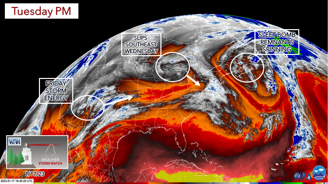
The storm responsible for Monday's mess of sleet and freezing rain spins around the Gulf of St. Lawrence through Wednesday. It's a blessing in the way that is there as it blocks an upper level ridge moving in from the southwest. A system over the Great Lakes will bring a round of icy, sleety junk to eastern New York and Vermont Tuesday night into early Wednesday, and slips off to the southeast of the region and misses Maine. Energy over the southwest ejects northeastward, and that is the source for the next storm on the way Thursday night into Friday.

Light snow for northern areas,
​isolated spotty mix or rain south for Wednesday

Picture
Wednesday 3 AM to 9 PM - As upper level energy pinwheels around the remnants of Monday's storm, snow showers in light to moderate intensity are possible over the far north. While that is going on, a warm front associated with the upper level ridge sticks its nose in over the south and may bring light pockets of freezing rain, sleet, a snow shower or a straight rain shower. 

Folks in the north may see 1-3" of snow and may have a few slick spots. I don't expect any travel issues in south of any concern. 

Snow on the way Thursday night into Friday

Picture
Thursday 6 PM to Saturday 1 AM - This is a nocturnal event which is helpful to keep this mostly snow. Snow and perhaps a bit of a mix along the southwest and MidCoast areas breaks out Thursday night. The storm is rather flat and doesn't begin to crank until it passes south of Nova Scotia Friday night.  Most of the precipitation is down with this one by daylight Friday over the south and by mid-morning over the east. An inverted trough set up keeps periodic snow showers going through the day, and may not end until Friday night. 
Picture
Since it is flat in nature, wind is not concern with this one. Some areas over the interior protected from the northeast breeze won't get wind. Shorelines may push 30-35, with DownEast shorelines likely to record the higher end speeds. 

For those with shoreline area concerns, I don't expect any concerns with coastal flooding with this event. Seas in the 3-6' range may bring some splash over, but that is typical with the astronomical tides on good day. We won't experience anything like what was seen with the Grinch storm. We'll dodge a bullet on this one. 
Picture
The highest amounts are expected over the south. The southwest coastal shorelines are a bit of question with the coastal front which may bring a mix and keep totals down there. There is certain amount of fluff factor with this over interior areas so that might "add" to the total theoretically, but we're talking roughly ¼ - ½"+ of water in frozen form here in the darker blues. 

The day won't be a total loss for travel. Outside of the snow showers that may add an inch or two in spots through Friday night which is factored into the totals above, it will be business as usual for Maine in January. 

Picture

The train keeps rolling

Picture
Saturday 7 PM to Thursday 7 PM - Looking at the European ensemble mean here shows the pattern continuing to be active. The next storm comes in from the south which is a common track for "Miller A" type NorEaster which could impact the area the first of next week, along with a similar storm potential for Wednesday into Thursday.

Where the coast dodges a potential problem with the astronomical tides on Friday, the tides will at maximum highs on Monday. 

Timing, intensity, impact, precipitation type all to be determined. For now, just know there is the chance. 

Temperature outlook through Sunday

We are in the coldest part of the year climatologically speaking, but the temps are running warm. Caribou's normal high and low for January 17th is 20° and 2°. For Portland, 32° and 15°. It appears at this point we could get into a below normal temperature pattern late in the month into early February. We'll see. 
Picture

Thank you as always for your support!

You may not like the weather, but I hope you like what I do! Please hit the like button
​on Twitter and Facebook, and share!

Financial donations to fund what I do are always appreciated!

Stay updated, stay on alert, and stay safe!

- Mike

NOTE: The forecast information depicted on this platform is for general information purposes only for the public and is not designed or intended for commercial use. For those seeking pinpoint weather information for business operations, you should use a private sector source. For information about where to find commercial forecasters to assist your business, please message me and I will be happy to help you.

Comments
    Picture

    Mike Haggett
    Kennebunk, ME

    Weather-Ready Nation
    Ambassador

    Certified Weather
    Forecaster
    Penn State '21

    American Meteorological Society

    National Weather Association
    ​
    ​SKYWARN-CWOP

    Matthew 19:26


    DONATE

    Picture
    Picture
    Picture
    Picture
    Picture
    Picture

    Picture

    Picture

    Picture

    Picture

    Picture

    Picture

    Picture

    Picture

    Picture

    Picture

    Picture

    Picture


    Archives

    January 2026
    December 2025
    November 2025
    October 2025
    September 2025
    August 2025
    July 2025
    June 2025
    May 2025
    April 2025
    March 2025
    February 2025
    January 2025
    December 2024
    November 2024
    October 2024
    September 2024
    August 2024
    July 2024
    June 2024
    May 2024
    April 2024
    March 2024
    February 2024
    January 2024
    December 2023
    November 2023
    October 2023
    September 2023
    August 2023
    July 2023
    June 2023
    May 2023
    April 2023
    March 2023
    February 2023
    January 2023
    December 2022
    November 2022
    October 2022
    September 2022
    August 2022
    July 2022
    June 2022
    May 2022
    April 2022
    March 2022
    February 2022
    January 2022
    December 2021
    November 2021
    October 2021
    September 2021
    August 2021
    July 2021
    June 2021
    May 2021
    April 2021
    March 2021
    February 2021
    January 2021
    December 2020
    November 2020
    October 2020
    September 2020
    August 2020
    July 2020
    June 2020
    May 2020
    April 2020
    March 2020
    February 2020
    January 2020
    December 2019
    November 2019
    October 2019
    September 2019
    August 2019
    July 2019
    June 2019
    May 2019
    April 2019
    March 2019
    February 2019
    January 2019
    December 2018
    November 2018
    October 2018
    September 2018
    August 2018
    July 2018
    June 2018
    May 2018
    April 2018
    March 2018
    February 2018
    January 2018
    December 2017
    November 2017
    October 2017

Proudly powered by Weebly