Pine Tree Weather
  • DISCUSSIONS
  • DONATE
  • MAPS
  • NWS BRIEFINGS
  • SATRAD
  • MARINE
  • SNOW / ICE OUTLOOK
  • RAIN OUTLOOK
  • CPC OUTLOOK
  • Kennebunk
  • OBSERVING WEATHER
  • Who We Are
  • My Photography
  • DISCUSSIONS
  • DONATE
  • MAPS
  • NWS BRIEFINGS
  • SATRAD
  • MARINE
  • SNOW / ICE OUTLOOK
  • RAIN OUTLOOK
  • CPC OUTLOOK
  • Kennebunk
  • OBSERVING WEATHER
  • Who We Are
  • My Photography

Light snow on the way to start the week

1/7/2018

Comments


A nuisance snow that could bring slick spots 

Picture
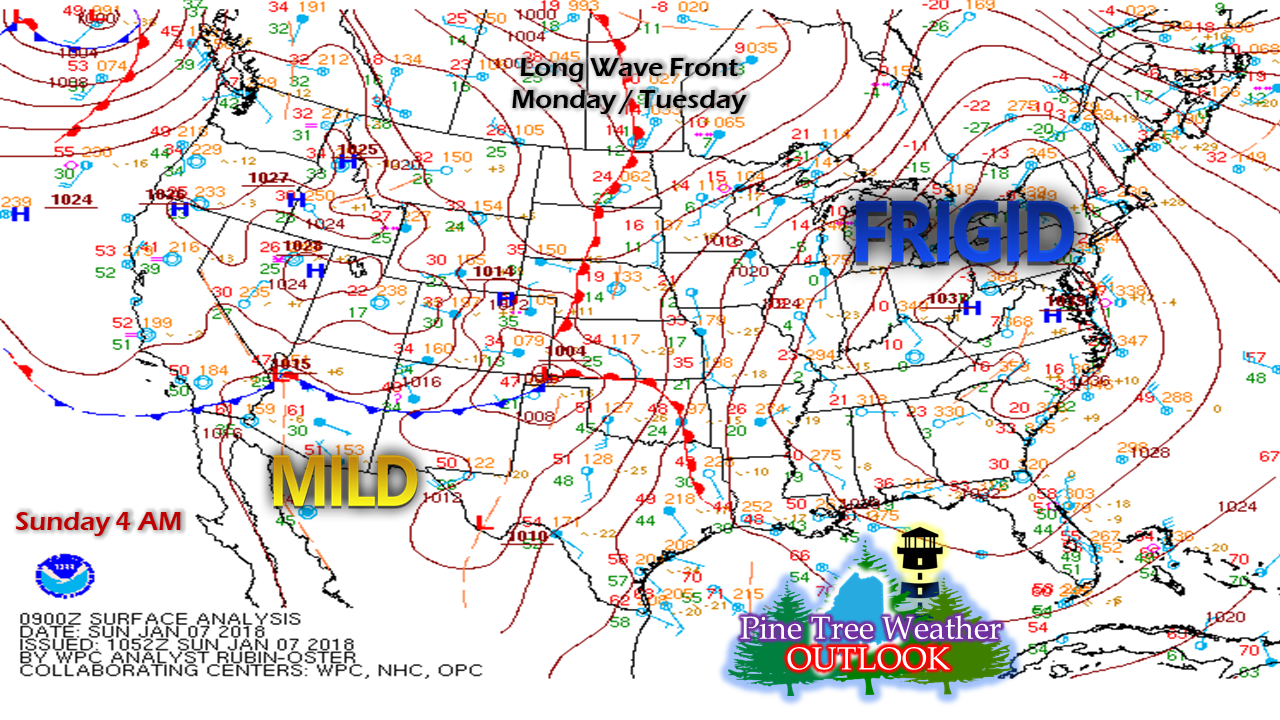
A look at the Sunday morning surface map shows the polar high to the southwest which will move east today, That will set up a southwest flow as a long wave warm front approaches the region to kick off the work week.

Outlook through Tuesday

Picture
As the polar high heads for the Atlantic, warm air moves in aloft and may touch off some flurries and squalls for the mountains and north Sunday. As warm air continues to build in ahead of the front, snow shower activity becomes more widespread overnight. The steadier snow falls Monday afternoon, which could turn the evening commute into a Body Shop Special. The deep cold of late will allow the snow to stick which will grease the roads up. The steadier snow turns back to snow showers by late evening Monday, and will linger into Tuesday.
Picture
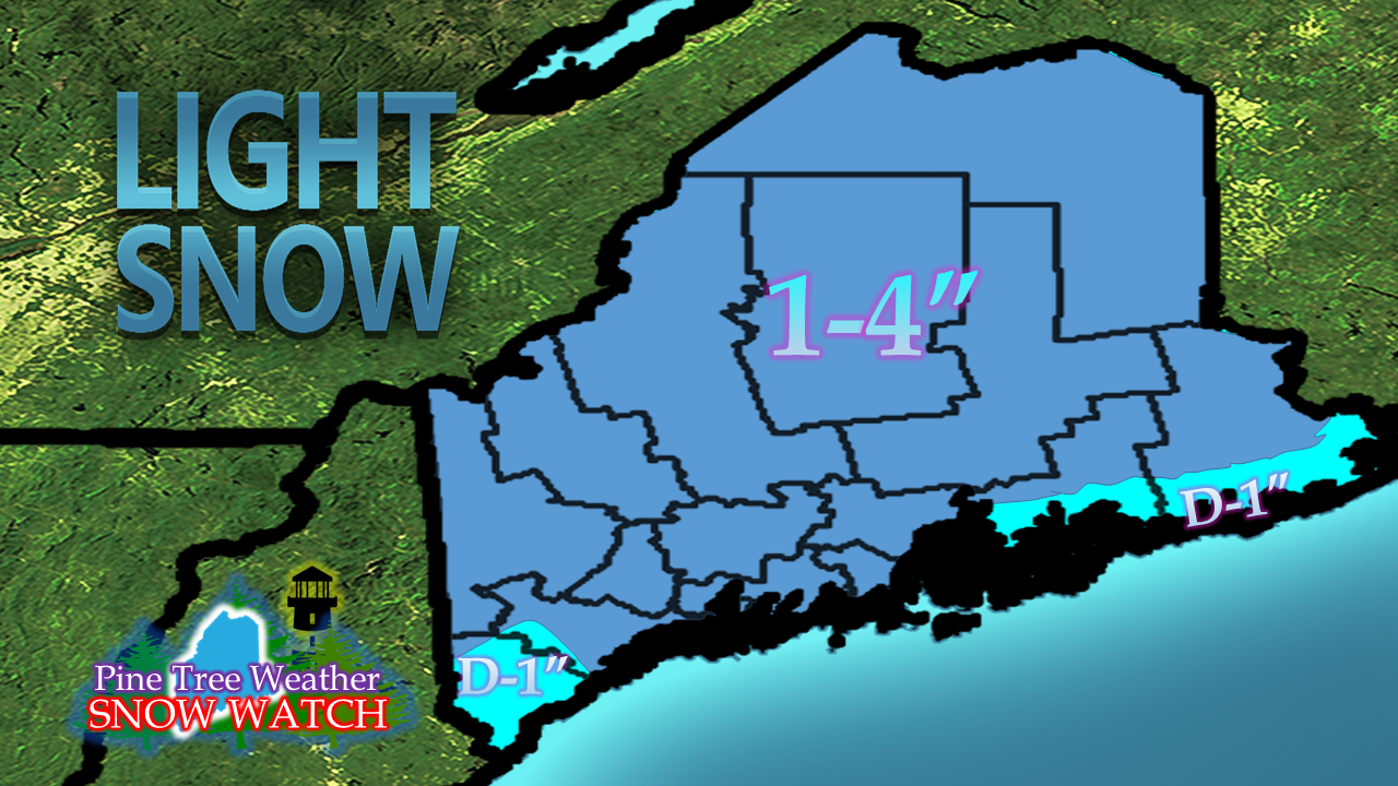
It won't be much, but enough to have to get out and clean up for most of the state. The high end amounts are likely for northern and eastern areas away from the shorelines, along with the ski hills. 

Warmer air arrives for late week

Picture
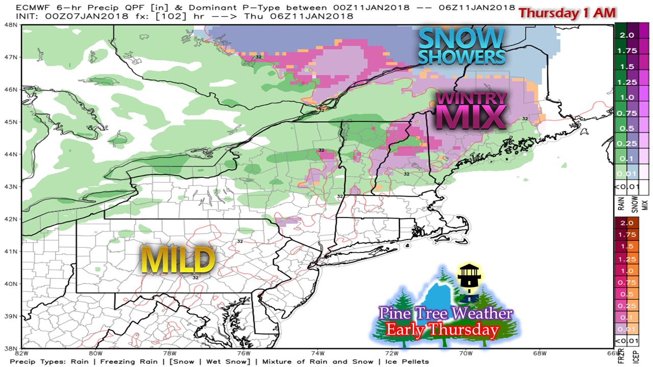
After a weak high takes over briefly on Wednesday, as that slides offshore, warmer air works in for the last half of the work week. Wednesday appears precipitation free until evening. As a warm front approaches from the southwest, it could bring a chance for a wintry mix of sleet and freezing drizzle or rain in the overnight as we head into Thursday.

While guidance has locked into warmer air taking control, I am throwing caution flags as to how the remainder of the week plays out. An "inside runner" is on the minds of models to impact the region Friday into Saturday, which could bring rain to the south and east and perhaps a wintry mix to areas of the mountains and north. Models and cold air have a rough time, so I am not willing to bank on the outcome of that just yet. 

I will update as the week progresses.

5-Day Outlook page is updated through Friday.

​- Mike 
Comments
    Picture

    Mike Haggett
    Kennebunk, ME

    Certified Weather
    Forecaster
    Penn State '21

    American Meteorological Society

    National Weather Association

    Weather-Ready Nation 
    Ambassador
    ​
    ​SKYWARN-CWOP

    Matthew 19:26


    Support
    Pine Tree Weather

    DONATE

    Picture

    Picture

    Picture

    Picture

    Picture

    Picture

    Picture

    Picture

    Picture

    Picture

    Archives

    January 2023
    December 2022
    November 2022
    October 2022
    September 2022
    August 2022
    July 2022
    June 2022
    May 2022
    April 2022
    March 2022
    February 2022
    January 2022
    December 2021
    November 2021
    October 2021
    September 2021
    August 2021
    July 2021
    June 2021
    May 2021
    April 2021
    March 2021
    February 2021
    January 2021
    December 2020
    November 2020
    October 2020
    September 2020
    August 2020
    July 2020
    June 2020
    May 2020
    April 2020
    March 2020
    February 2020
    January 2020
    December 2019
    November 2019
    October 2019
    September 2019
    August 2019
    July 2019
    June 2019
    May 2019
    April 2019
    March 2019
    February 2019
    January 2019
    December 2018
    November 2018
    October 2018
    September 2018
    August 2018
    July 2018
    June 2018
    May 2018
    April 2018
    March 2018
    February 2018
    January 2018
    December 2017
    November 2017
    October 2017

    RSS Feed

Proudly powered by Weebly