Wet north, mainly dry south for Friday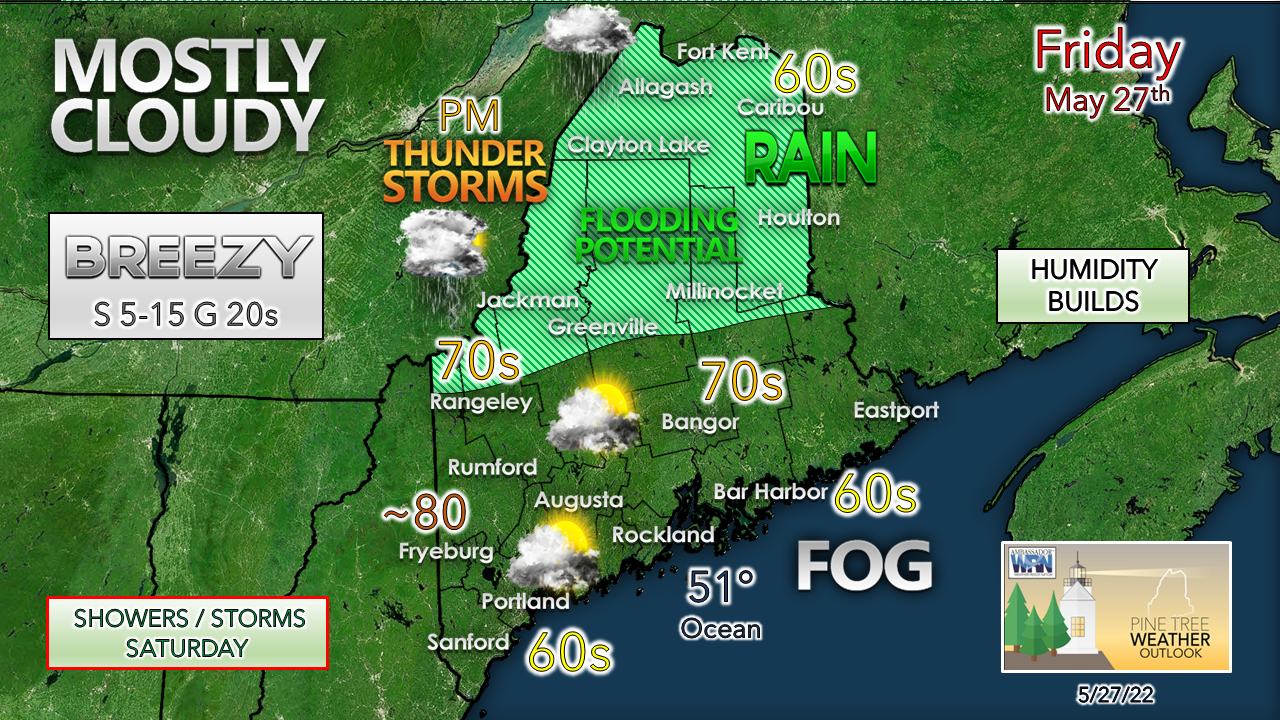 A stationary front is parked over northern areas, allowing rain to persist through the day. A southwesterly flow aloft raises humidity levels, thus increasing the risk of afternoon thunderstorms over the mountains and north in the afternoon. Areas of fog are expected to develop for MidCoast points eastward later in the day. Southwest coastal areas may see fog develop Friday night. The fog could be locally dense heading into Saturday morning. 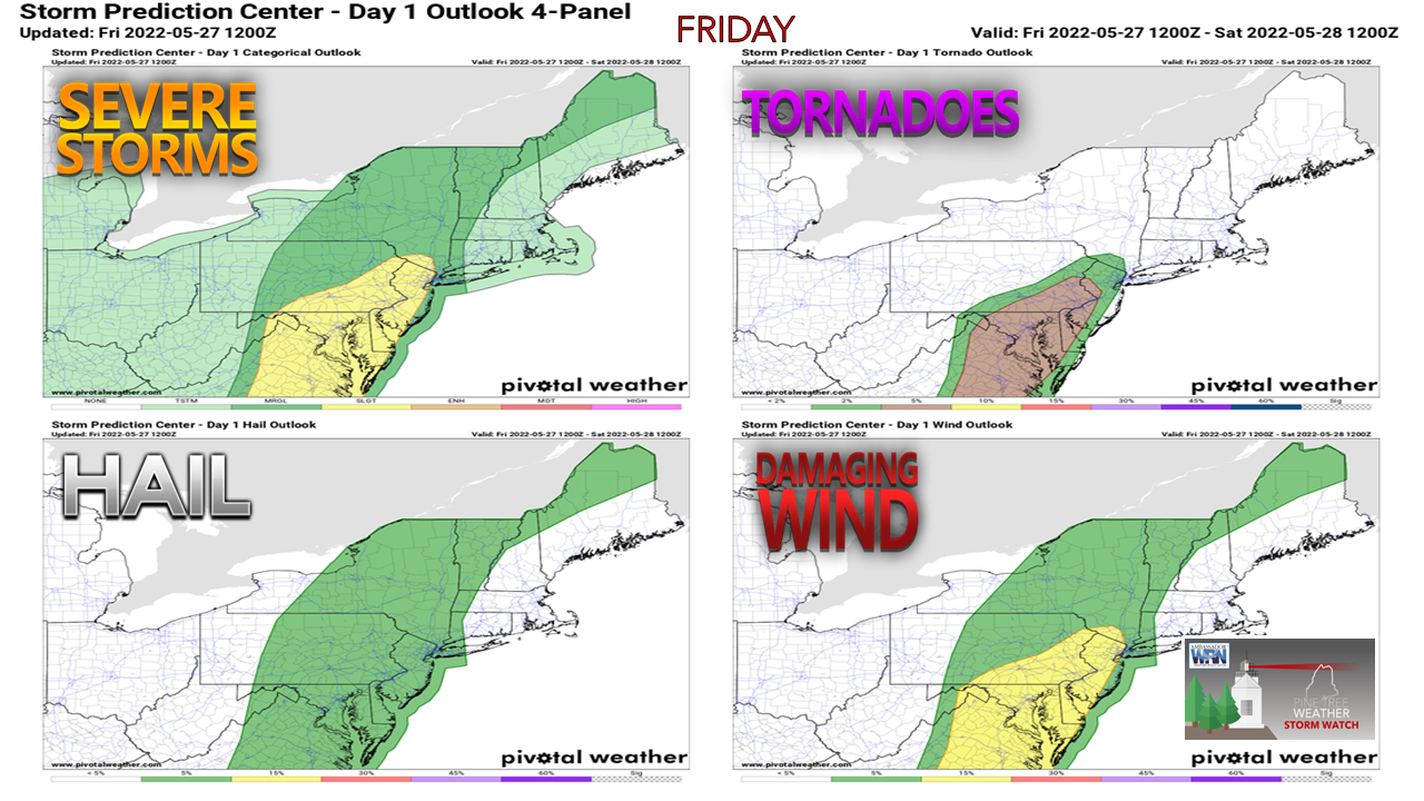 The Storm Prediction Center Day 1 Outlook highlights a low-end threat for strong to severe storms over the mountains and north Friday into Friday night. With the increase of humidity raising surface CAPE values in the 500-1000 j/kg level, all it will take is some sun to poke through for a time to initiate storms. As I have mentioned in my Facebook posts over the past couple of days, this is a sun dependent situation whether strong storms develop. Small hail and gusty wind could accompany storms IF they develop. 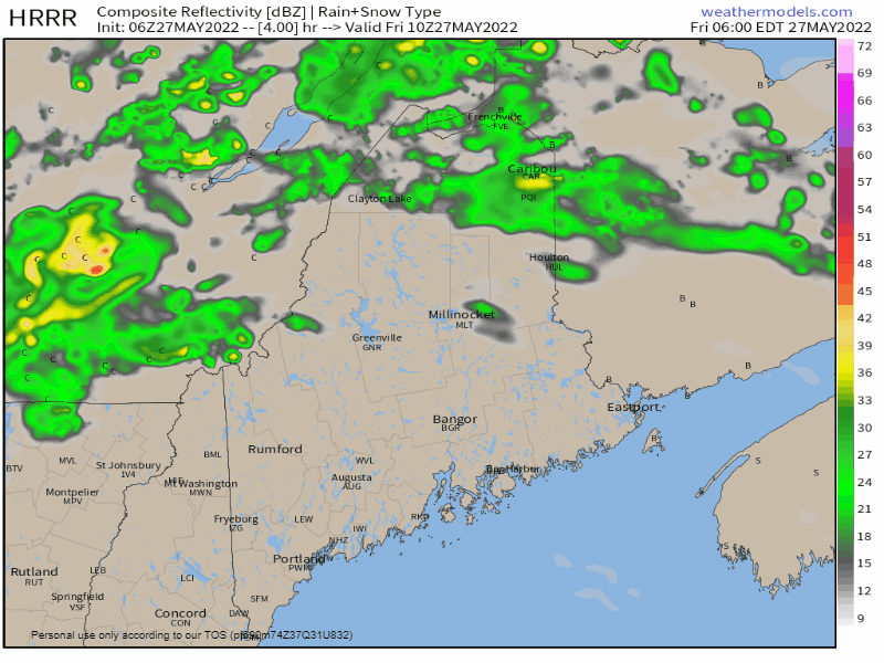 Friday 6 AM to Saturday Midnight - Given the trajectory of the system and the veering wind direction along the front, this sets up a training potential for storm that do develop. When storms train, they bring flash flood potential rain that could appear to be relentless to those caught in it. For folks pitching a tent in the north woods, it could be a very soggy night. Pick your campsite with flood potential in mind. Chances for rain and storms for all Saturday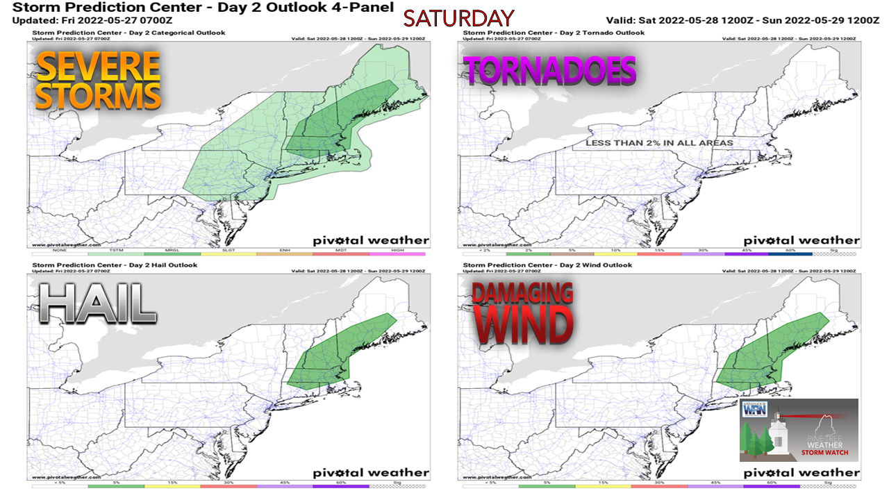 The Storm Prediction Center Day 2 Outlook shows a marginal threat for storms over the foothills and coastal plain region, with small hail and gusty wind possible. Again, this is a sun dependent situation. Areas that see the sun for a period time to warm the surface can expect thunder in the afternoon. Areas stuck in the clouds, or coastal areas dealing with fog are unlikely to see storms of concern. 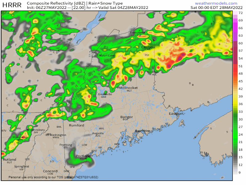 Saturday Midnight to Sunday Midnight - With the cold front approaching from the west and the veering wind direction riding along it, this will once again set up a flash flooding situation from training storms or downpours. Well saturated areas in the mountains and north from the rain and potential storms of Friday and Friday night can bet on areas flooding to occur when downpours come. The front makes progress to the east through the afternoon into Saturday night, clearing Washington County in the wee hours of Sunday morning. Expect breezy conditions for Sunday as an area of weak high pressure moves in.  Outlook through midweek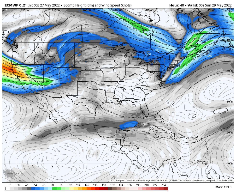 Saturday 8 PM to Tuesday 8 PM - A look at the jet stream for an idea of what to expect through midweek shows a ridge containing hot and humid air to the south being cut off by an upper-level low developing over Labrador. Maine gets caught in the middle of this battle for upper air superiority and as a result deals with mostly cloudy / partly sunny conditions for the most part through midweek. As the upper-low flexes its muscle, that sends a backdoor cold front in from the northeast, keeping northern areas on the cool side, and brings a chance for showers over southwestern areas Monday night into early Tuesday. The strength and position of the upper-low will dictate temperatures and cloud cover heading into the latter part of the week. Temperature outlook through Wednesday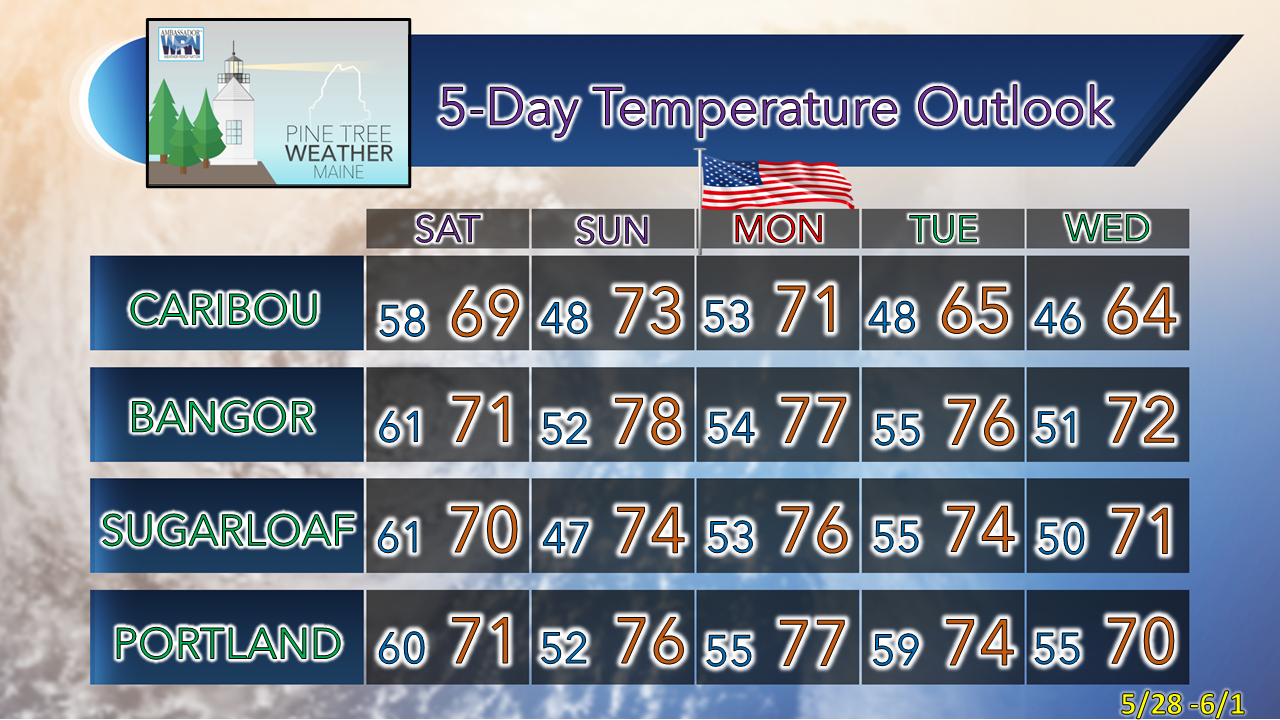 Be prepared to receive alerts and stay updated!
 For more information in between posts, please follow Pine Tree Weather on Facebook and Twitter. Thank you for supporting this community-based weather information source which operates by reader supported financial contributions. Thank you as always for your support! - Mike NOTE: The forecast information depicted on this platform is for general information purposes only for the public and is not designed or intended for commercial use. For those seeking pinpoint weather information for business operations, you should use a private sector source. For information about where to find commercial forecasters to assist your business, please message me and I will be happy to help you. |

Mike Haggett
|