Pine Tree Weather
  • DISCUSSIONS
  • DONATE
  • WEATHER WALL
  • MAPS
  • RAIN OUTLOOK
  • SEVERE
  • MARINE
  • CPC OUTLOOK
  • Kennebunk
  • MY BIO
  • PTW IN MEDIA
  • OBSERVING WEATHER
  • INTERNSHIPS
  • INTERN ALUMNI
  • DISCUSSIONS
  • DONATE
  • WEATHER WALL
  • MAPS
  • RAIN OUTLOOK
  • SEVERE
  • MARINE
  • CPC OUTLOOK
  • Kennebunk
  • MY BIO
  • PTW IN MEDIA
  • OBSERVING WEATHER
  • INTERNSHIPS
  • INTERN ALUMNI

Model volatility concerning late week event

2/17/2021

Comments


Expect a potential shift in forecast ideas

Picture
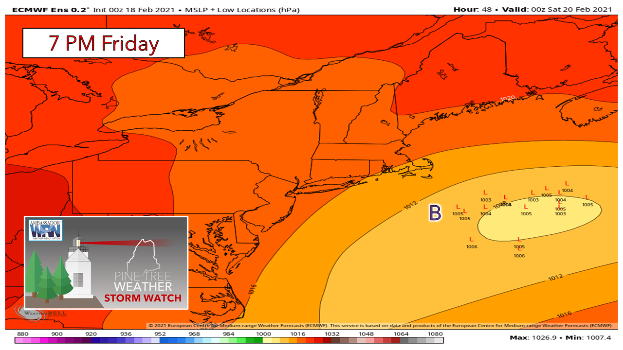
I mentioned on Facebook Tuesday afternoon that there is potential for shift in model ideas in regards to the late week storm, and that idea remains. The National Weather Service Gray office highlights the complex issue trying to forecast this one in its Wednesday morning discussion. The key point here is models are once again struggling to get valuable data from remote areas in northwestern Canada that are poorly sampled, and that is causing drifting and in some cases the flip-flopping of model ideas.

The European ensemble depiction of low pressure centers above shows a great deal of scattered ideas, which is rather alarming for an event that could begin within a 60 hours. 

As a forecaster, my personal philosophy is to shoot straight with you, and over the past month or so it has been extremely frustrating at times to give you a "no bull" answer. The one thing I have said and will continue to say is model volatility remains high, so shifts in ideas can come fairly quick closer to the event. This is why it is important to stay on top of the forecast, regardless if you are getting it from the National Weather Service, local media, or from here. 
Picture
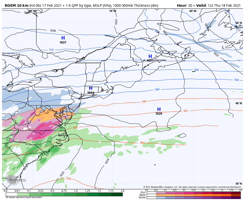
What is going on here has to do with the timing of phasing with northern stream and southern stream, along with high pressure to the north. The thermal energy models use to figure out storm potential comes in the form of vorticity. I show those ideas once in awhile to make points,  This upper level vorticity ties into how models depict the surface.

In this deterministic surface map idea from the Canadian RGEM model, it shows flat area of low pressure bringing a decent snow for southern New England, south of the benchmark 40°N / 70° W. The storm does not appear to phase and crank until south of Nova Scotia Saturday morning. It also shows a light amount of snow for the Maine coast, and that is about it. A jog west changes the ballgame from flurries to a 2-5" snow event for the shoreline counties. 

The blunt force truth here is I don't trust any of the model ideas yet. The energy that needs to be sampled drops down into a sampling area Wednesday morning. A better idea should come Wednesday afternoon. If I have time, I will draft up a snowfall idea and post it on Facebook, and talk more about it here Thursday morning. 

​Be prepared to receive alerts and stay updated!

Picture
​​​BE PREPARED WITH A NOAA Weather Radio.

​For $20-$40, it could provide important information to you when you need it. The weather bands are standard on most public safety scanners, and newer scanner models. Weather radios can be programmed for auto alert.  Click here for more information.

​​​​​► ► For the latest official forecasts, bulletins and advisories, please check in with the National Weather Service in Gray for western and southern areas, or Caribou for northern and eastern parts of Maine
Picture

For more information in between posts, please follow Pine Tree Weather on Facebook and Twitter. 

​Thank you for supporting this community based weather information source which operates by reader supported financial contributions. 

Stay updated, stay on alert, and stay safe!

Thank you as always for your support! 

​- Mike
Comments
    Picture

    Mike Haggett
    Kennebunk, ME

    Weather-Ready Nation
    Ambassador

    Certified Weather
    Forecaster
    Penn State '21

    American Meteorological Society

    National Weather Association
    ​
    ​SKYWARN-CWOP

    Matthew 19:26


    DONATE

    Picture
    Picture
    Picture
    Picture
    Picture

    Picture

    Picture

    Picture

    Picture

    Picture

    Picture

    Picture

    Picture

    Picture

    Picture

    Picture

    Picture


    Archives

    April 2025
    March 2025
    February 2025
    January 2025
    December 2024
    November 2024
    October 2024
    September 2024
    August 2024
    July 2024
    June 2024
    May 2024
    April 2024
    March 2024
    February 2024
    January 2024
    December 2023
    November 2023
    October 2023
    September 2023
    August 2023
    July 2023
    June 2023
    May 2023
    April 2023
    March 2023
    February 2023
    January 2023
    December 2022
    November 2022
    October 2022
    September 2022
    August 2022
    July 2022
    June 2022
    May 2022
    April 2022
    March 2022
    February 2022
    January 2022
    December 2021
    November 2021
    October 2021
    September 2021
    August 2021
    July 2021
    June 2021
    May 2021
    April 2021
    March 2021
    February 2021
    January 2021
    December 2020
    November 2020
    October 2020
    September 2020
    August 2020
    July 2020
    June 2020
    May 2020
    April 2020
    March 2020
    February 2020
    January 2020
    December 2019
    November 2019
    October 2019
    September 2019
    August 2019
    July 2019
    June 2019
    May 2019
    April 2019
    March 2019
    February 2019
    January 2019
    December 2018
    November 2018
    October 2018
    September 2018
    August 2018
    July 2018
    June 2018
    May 2018
    April 2018
    March 2018
    February 2018
    January 2018
    December 2017
    November 2017
    October 2017

Proudly powered by Weebly