
The stage is set for the week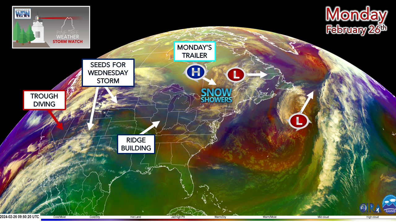 A heads up for those in western and southern areas and the folks in New Hampshire that the NWS Gray radar is offline and is expected to return to service on Tuesday. Snow showers are working through the region Monday morning and may not be picked up by adjacent radars. Please use the mPING app to report any observations as that is extremely helpful. Eventually, the Gray radar will go offline for several months as it will be raised to deal with beam blockage. This is as good time as any to use mPING as it will be called upon for assistance when that time comes. Snow squall potential for the north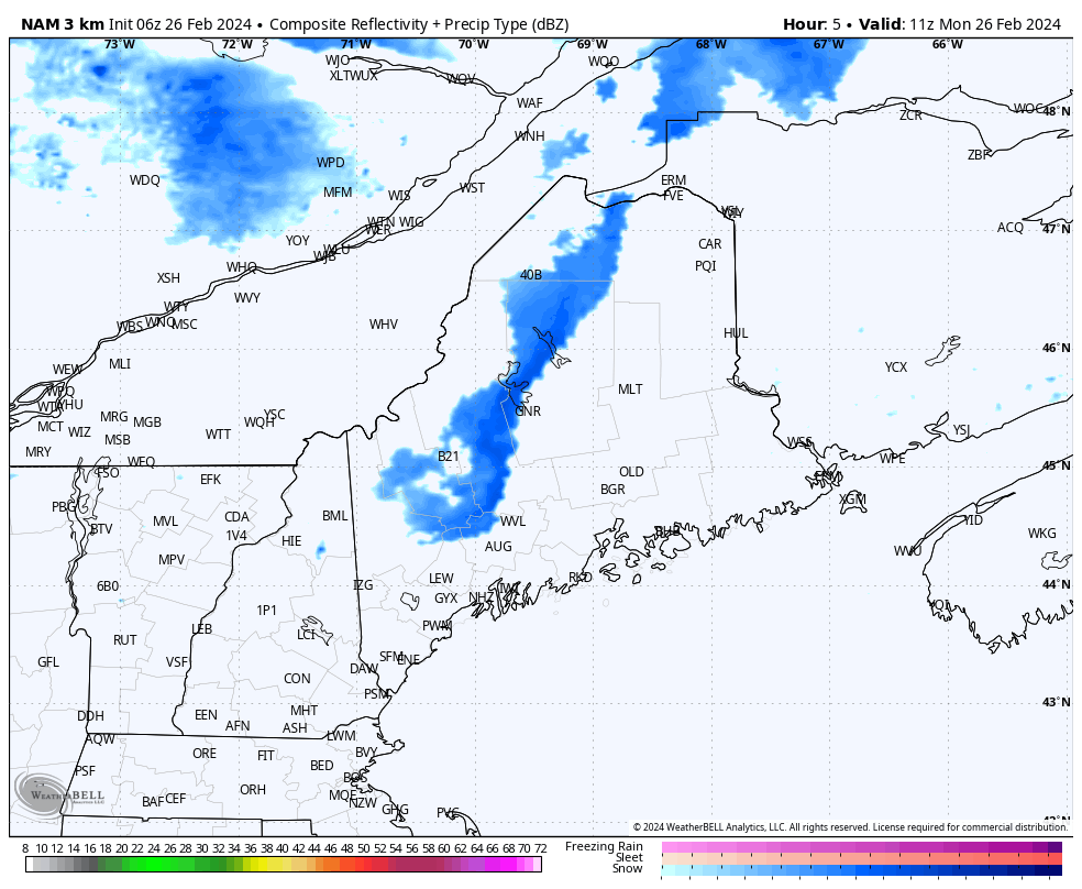 Monday 6 AM (11z) to 7 PM (00z Tuesday) - The first wave of light snow showers pass through with little fanfare or impact. The second wave passes through in the afternoon which may touch off some snarky squalls over the north. These may impact the evening drive with reduced visibility, gusty wind, and a quick inch of snow possible. Time will tell if any squall warnings will be issued. For those in the The County, please stay aware of the potential. Wednesday storm update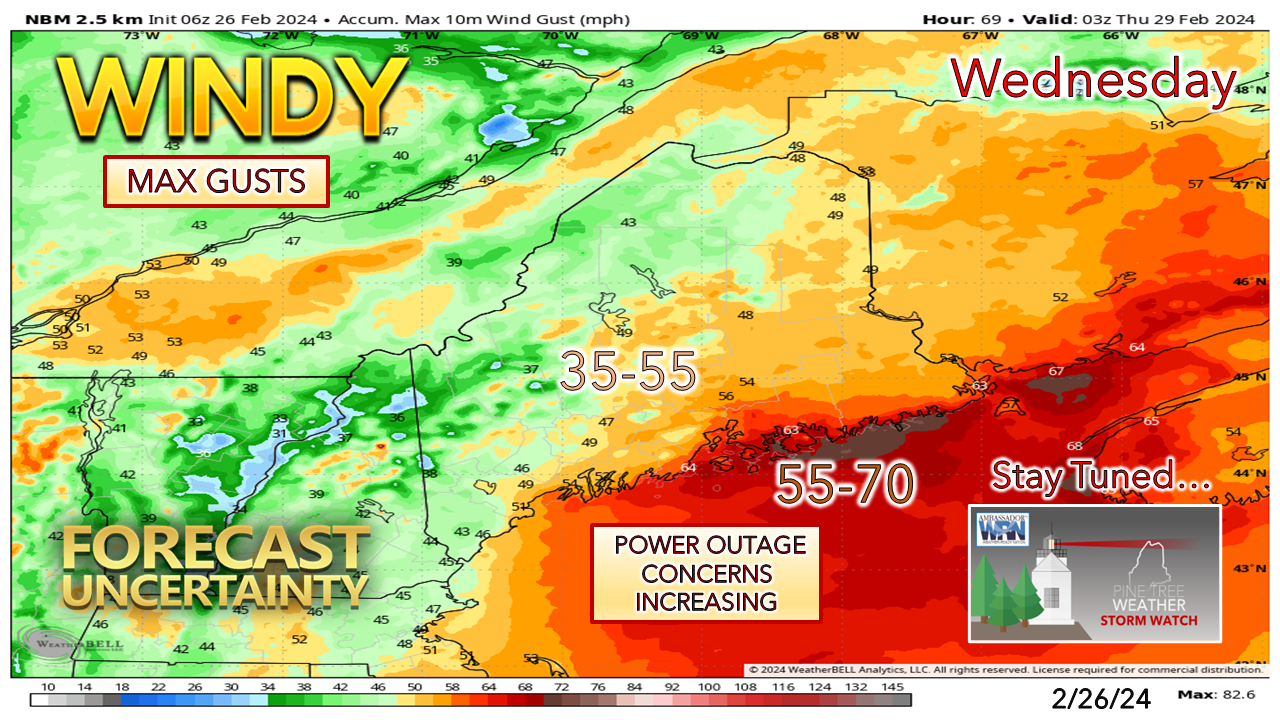 The idea presented here on Sunday for the potential for power outages for MidCoast and DownEast areas continues to hold service. There remains some discrepancy in modeling over the strength of the low-level jet, and the possibility of a capping inversion plays a role in this. The ideas of the low-level jet are upwards of 70-90 knots at around 2,000 feet Wednesday afternoon. Where the cap comes into play has much to do with the influence of the ocean. Given the fact that the airmass is tropical, the idea of a damaging wind threat is certainly on the discussion table. Add to that the risk of locally heavy rain and the potential for a thunderstorm, those both carry a downdraft threat. While it appears that it will be a windy all day on Wednesday, the main threat for the strongest gusts is in the afternoon into the early evening as a cold front sweeps through. 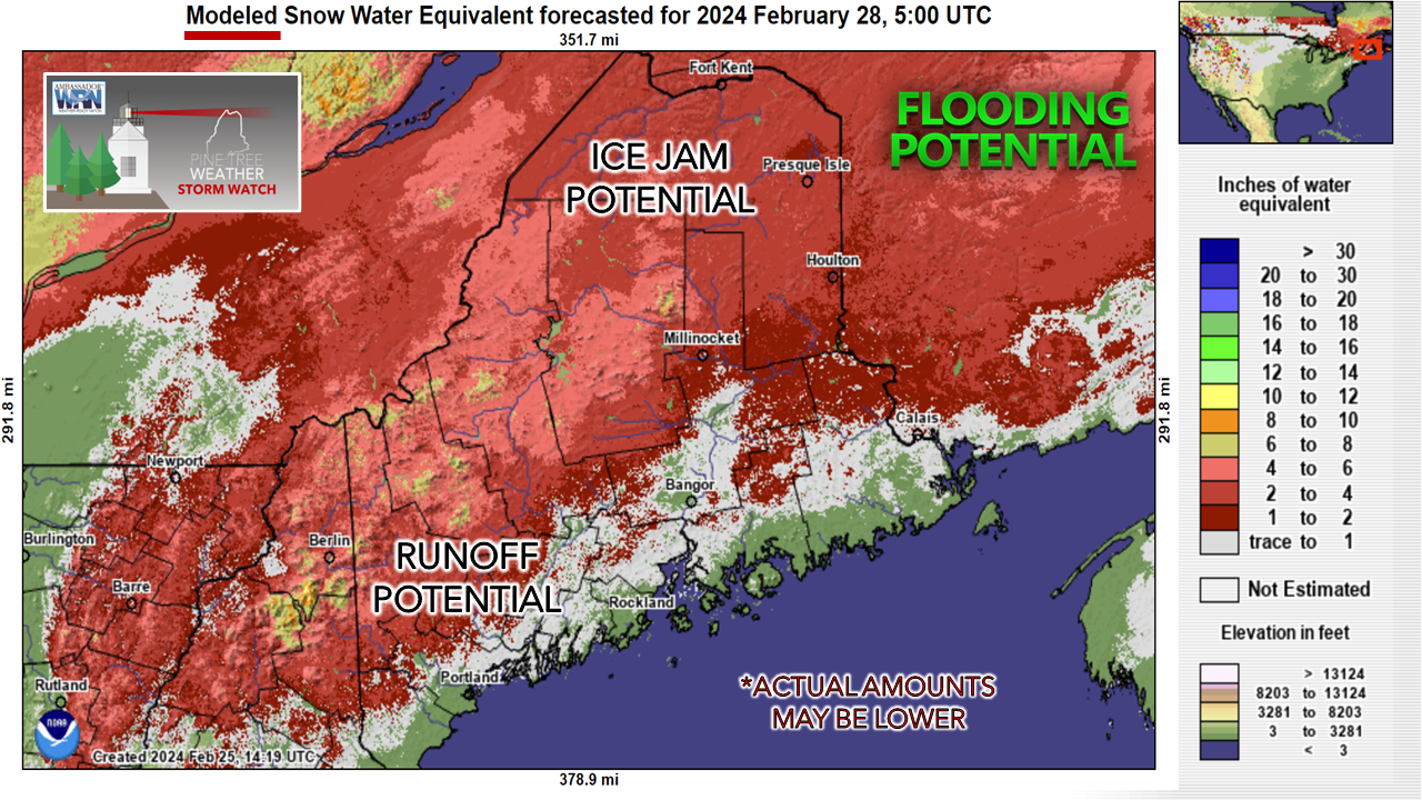 This snow water equivalent idea by the National Operational Hydrologic Remote Sensing Center shows a general 2-5" worth of liquid that is potentially locked in snow cover, with a higher amount in the mountains. This idea may be overdone but with the dynamics of the system, the snowpack is likely to take a dramatic hit. Dew point values ≥32° for upwards of 30 hours, areas of fog, along with rain showers in various intensities will no doubt cause runoff due to melting. While I do not expect a situation like the region experienced in December, localized flooding is a strong possibility. In the north, the threat is for ice jams. Fortunately, there is not a whole lot of it, but enough to cause issues. 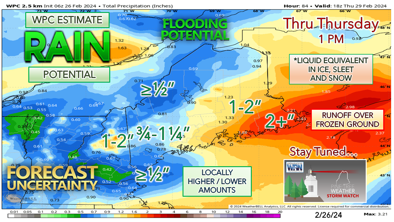 Eastern areas that have little to no snow remaining escape any significant flooding, but with the ground frozen and potential for 2"+ of rainfall, sensitive areas along with flood prone basements are a concern there. As mentioned in Sunday's post, all of this water freezes up as temperatures crash Wednesday night. which could bring a black ice problem for many areas Thursday morning. 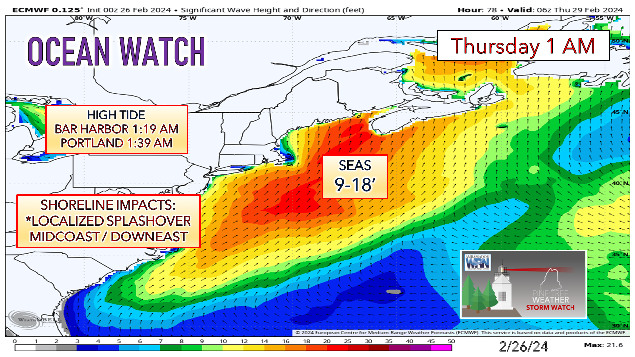 The good news for the shorelines are the tides are off astronomical levels. The seas will be up, however, which may cause localized splash over and the potential for some erosion in areas exposed from the January shoreline obliterators. The threat for surge and flooding is very low overall. Check out PTW for information 24 hours a day Thank you to Allspeed Cyclery & Snow in Portland, Downeast Aerial Photography in Rockland, Dutch Elm Golf Club in Arundel, and Sunrise Property Services in Bridgton, for partnering with Pine Tree Weather. Special thanks to all the individuals and businesses who financially contribute. I sincerely appreciate your support. Always have MULTIPLE ways to receive weather alerts. Stay updated, stay on alert, and stay safe! - Mike PRINT MEDIA: Feel free to quote and cite my work here for your stories. Please give me the professional courtesy of knowing that you are referencing my material so I can read your final product and acknowledge it on my media and link it on the PTW IN MEDIA page here on the website. Feel free to send me a message via the Facebook page or Twitter (X) to get my phone number if necessary. Thank you! NOTE: The forecast information depicted on this platform is for general information purposes only for the public and is not designed or intended for commercial use. For those seeking pinpoint weather information for business operations, you should use a private sector source. For information about where to find commercial forecasters to assist your business, please message me and I will be happy to help you. |

Mike Haggett
|


