Original post from Facebook#Maine #MEwx MONDAY March 25th Update – OUTLOOK THROUGH EASTER
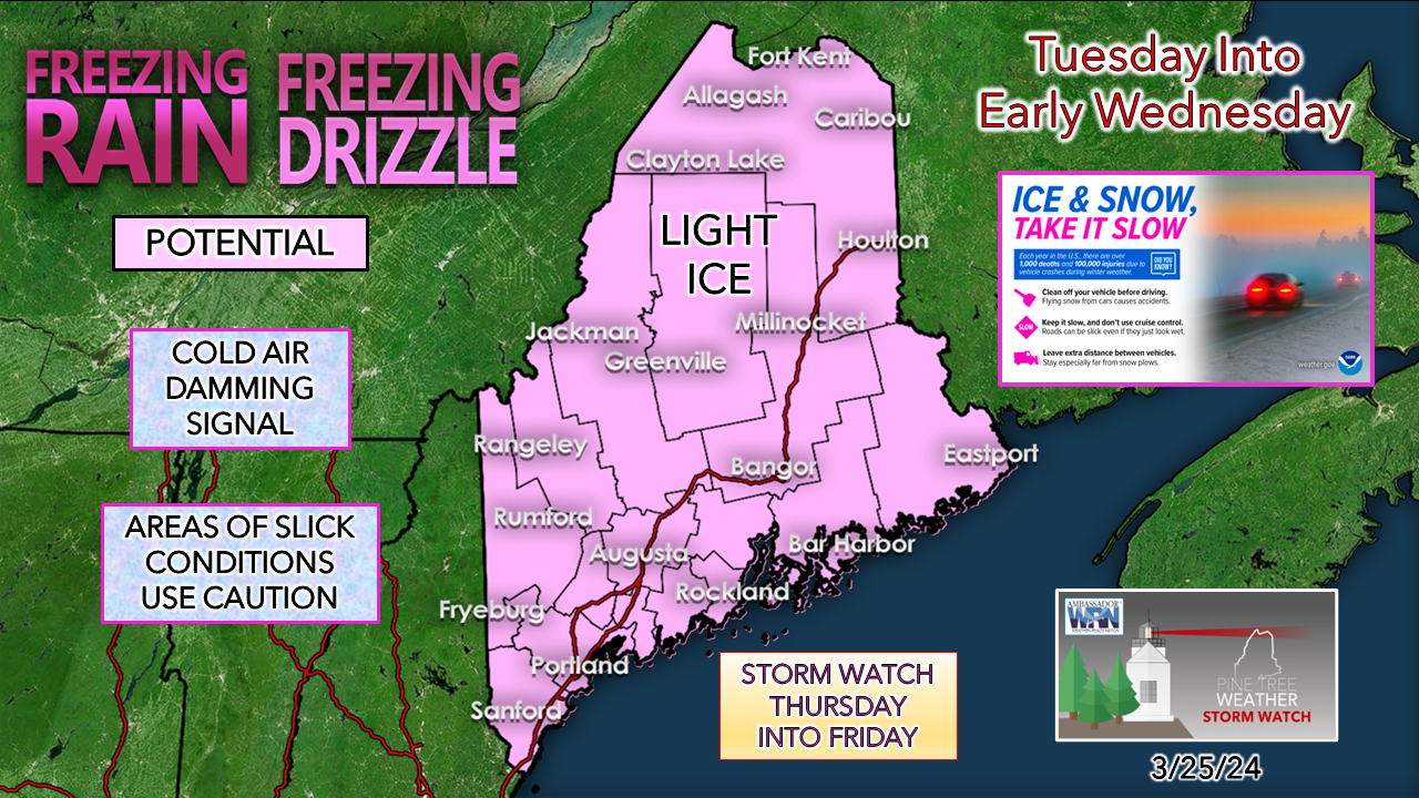
Before I get into this, a tip of the Stetson is to Kennebunk Power & Light for getting my neighborhood back online late Sunday afternoon. When I don’t have power, I don’t sleep due to a medical condition, so your hard work and efforts are greatly appreciated. At last check around 4:45 AM, over 108,000+ are still awaiting restoration. The good news is that weather conditions will be favorable for continuing the efforts to get folks hooked back up. LIGHT ICE IS ON THE WAY TUESDAY INTO EARLY WEDNESDAY… Now that most areas have snowpack, old friend Cold Air Damming can crawl out of the closet. The setup is ideal for it. A strong high around Labrador and an offshore upper-low to the south set up a northeast wind flow. An approaching weak frontal boundary funnels moisture in from the ocean, which kicks up shower and drizzle activity, and in certain areas, it may freeze on roads, walkways, and vehicles. Accretion amounts are expected to be light, from trace amounts to perhaps a tenth of an inch in isolated spots in the western foothills, central highlands on over into eastern interior areas, and with elevation. There could be freezing fog in spots around open bodies of water. Overall, it’s not a big deal, but it doesn’t take much ice to ruin a day, whether driving or walking. STALLED BOUNDARY OFFSHORE SETS UP POTENTIAL FOR OCEAN STORM THURSDAY INTO FRIDAY… The ideas that are out there on this one are similar to what the region experienced with the storm this past Saturday. While operational ideas have the front far enough offshore to bring little in the way of frozen precipitation at this point, it is worth noting that the trend has been for a westward shift as time goes along. Ensemble ideas hint at more of a warmer than colder outcome at this vantage point, but with cold air lurking to the north, a more westward shift would tap into that. This could be another juicy system with 1-2”+ of liquid equivalent to work with. Depending on how this plays out, it could be problematic in the form of flooding from snowmelt runoff with the warmer idea and a snow-junk mix-rain situation with a cooler one. Our annual April Fools storm may come a bit early. Stay tuned! EASTER WEEKEND appears cold with breezy conditions, but otherwise precipitation-free. You folks are the best, and I appreciate each of you. Thanks to your support, PTW continues to grow, and I am sincerely grateful for that. - Mike |
Mike Haggett
|


